Dihibahiri
Dihibahiri
Dihi Bahiri | |
|---|---|
Village | |
 Dihibahiri Location in West Bengal, India | |
| Coordinates: 21°51′25″N 87°46′32″E / 21.8569°N 87.7755°ECoordinates: 21°51′25″N 87°46′32″E / 21.8569°N 87.7755°E | |
| Country | |
| State | West Bengal |
| District | Purba Medinipur |
| Population (2011) | |
| • Total | 161 |
| Languages | |
| • Official | Bengali, English |
| Time zone | UTC+5:30 (IST) |
| Lok Sabha constituency | Kanthi |
| Vidhan Sabha constituency | Kanthi Uttar |
| Website | purbamedinipur |


Dihibahiri is a village in the Contai III CD block in the Contai subdivision of the Purba Medinipur district in the state of West Bengal, India.
History[]
When the largest man-made waterbody in the area, Bhimsagar, was being dug, many antiquities were recovered and some were believed to belong to the Shunga-Kushan era (around 1st BC to 1st century AD). Much later, the Contai area was a part of the Hijli Kingdom, which existed between 1687 and 1886.[1]
Geography[]
M: municipal city/ town, CT: census town, R: rural/ urban centre, centre, H: historical/ religious S: port, sea-beach
Owing to space constraints in the small map, the actual locations in a larger map may vary slightly
Location[]
Dihibahiri is located at 21°51′25″N 87°46′32″E / 21.8569°N 87.7755°E.
Marishda is about 10 km from Contai on the Contai-Nandakumar Road (National Highway 116B). Dihibahiri is linked with Marishda by a short stretch of local roads.[1]
Note: The map alongside presents some of the notable locations in the subdivision. All places marked in the map are linked in the larger full screen map.
Demographics[]
According to the 2011 Census of India, Dihibahiri had a total population of 161, of which 79 (49%) were males and 82 (51%) were females.[2]
Culture[]
According to the board put up by the Archaeological Survey of India at Dihibahiri, the temple of Jagannath was built in 1584. It further says that it was heard that Bhimsen Mahapatra, King of Odisha, built this temple. It is a rekha-type structure with jagmohana (pirha type) in the front. (A picture of the board is provided. It can be enlarged to verify the information).
Dihibahiri Jagannath temple is a state protected monument.[3]
Dihibahiri picture gallery[]

Jagannath deul temple

Jumping lion on the temple wall
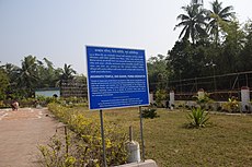
ASI information board


The pictures are a part of Wiki Explores Purba Medinipur programme, an initiative by West Bengal Wikimedians User Group
Healthcare[]
Kharipukuria Block Primary Health Centre at Kharipukuria, PO Nachinda Bazar (with 10 beds) is the main government medical facility in Contai III CD block.[4]
References[]
- ^ Jump up to: a b "Next weekend you can be at Bahiri". The Telegraph, 6 November 2005. Retrieved 12 August 2020.
- ^ "CD block Wise Primary Census Abstract Data(PCA)". West Bengal – District-wise CD blocks. Registrar General and Census, India. Retrieved 12 August 2020.
- ^ List of State Protected Monuments as reported by the Archaeological Survey of India Archived 2013-05-23 at the Wayback Machine.
- ^ "Health & Family Welfare Department". Health Statistics. Government of West Bengal. Retrieved 27 March 2019.
External links[]
| Wikimedia Commons has media related to Dihibahiri, Contai III CD block. |
| show Cities, towns, locations and neighbourhoods in Purba Medinipur District, Medinipur division |
|---|

- Villages in Purba Medinipur district
- Tourist attractions in Purba Medinipur district