Ramjibanpur
Ramjibanpur | |
|---|---|
City | |
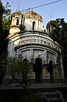
 Sridharlaljiu temple in Ramjibanpur | |
 Ramjibanpur Location in West Bengal, India | |
| Coordinates: 22°50′N 87°37′E / 22.83°N 87.62°ECoordinates: 22°50′N 87°37′E / 22.83°N 87.62°E | |
| Country | |
| State | West Bengal |
| District | Paschim Medinipur |
| Government | |
| • Type | Municipality |
| • Body | Ramjibanpur Municipality |
| Elevation | 11 m (36 ft) |
| Population (2011) | |
| • Total | 19,611 |
| Languages | |
| • Official | Bengali, English |
| Time zone | UTC+5:30 (IST) |
| PIN | 721242 |
| Lok Sabha constituency | Arambagh |
| Vidhan Sabha constituency | Chandrakona |
| Website | ramjibonpurmuniciality |


Ramjibanpur is a city and a municipality in the Ghatal subdivision of the Paschim Medinipur district in the Indian state of West Bengal.
Geography[]
M: municipal city/ town, R: rural/ urban centre, H: historical/ religious centre
Owing to space constraints in the small map, the actual locations in a larger map may vary slightly
Location[]
Ramjibanpur is located at 22°50′N 87°37′E / 22.83°N 87.62°E.[1] It has an average elevation of 11 metres (36 feet).
Area overview[]
Ishwar Chandra Vidyasagar, scholar, social reformer and a key figure of the Bengal Renaissance, was born at Birsingha on 26 September 1820.[2][3]
Ghatal subdivision, shown in the map alongside, has alluvial soils. Around 85% of the total cultivated area is cropped more than once.[4] It has a density of population of 1,099 per km2, but being a small subdivision only a little over a fifth of the people in the district reside in this subdivision. 14.33% of the population lives in urban areas and 86.67% lives in the rural areas.[5]
Note: The map alongside presents some of the notable locations in the subdivision. All places marked in the map are linked in the larger full screen map.
Demographics[]
As per 2011 Census of India, Ramjibanpur had a total population of 19,611 of which 10,030 (51%) were males and 9,581 (49%) were females. Population in the age range 0–6 years was 2,109. The total number of literate persons in Ramjibanpur was 14,735 (84.19% of the population over 6 years).[6]
As of 2001 India census,[7] Ramjibanpur had a population of 17,363. Males constitute 51% of the population and females 49%. Ramjibanpur has an average literacy rate of 72%, higher than the national average of 59.5%: male literacy is 78%, and female literacy is 66%. In Ramjibanpur, 14% of the population is under 6 years of age.
Culture[]
David J. McCutchion mentions:[8]
- The Vishnu temple in Dayalbazar as a small flat roofed or chandni type, with terracotta decoration, built in 1833, measuring 14’ square’
- The Radhakanta temple in Natunhat, in the same category as the Vishnu temple, with terracotta decoration, built in 1829, measuring 14’ 10” x 15’.
- The Sridhara and Shiva temples (two attached temples), in the same category as the Vishnu temple, with extended façade for extra chambers, plain, measuring 24’ 3” x 3’.
- a pancha-ratna temple with ridged rekha turrets and porch on triple archway, of the standard West Bengal type with facades fully decorated.
- a pancha-ratna with ridged rekha turrets and single entrance with figures above the archway and around the façade.
- a West Bengal nava-ratna, with terracotta decoration, now fallen to ruin.
Ramjibanpur picture gallery[]
Damodar temple of Piri family

Damodar temple
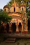
Sridharlaljiu temple of Piri family
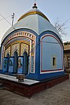
Buro Shiva temple, possibly built in 1866
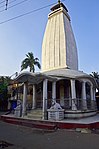
Parbatinath temple: the old temple built in 1801-02 collapsed and this new temple was built


The pictures are a part of Wiki Explores Paschim Medinipur programme, an initiative by West Bengal Wikimedians User Group.
References[]
- ^ Falling Rain Genomics, Inc - Ramjibanpur
- ^ Murshid, Ghulam. "Vidyasagar, Pundit Iswar Chandra". Banglapedia. Retrieved 24 July 2016.
- ^ "Ishwar Chandra Vidyasagar". www.whereincity.com. Retrieved 24 July 2016.
- ^ "District Human Development Report Paschim Medinipur, 2011". page 27-28. Department of Planning and Statistics, Government of West Bengal. Retrieved 10 September 2020.
- ^ "District Statistical Handbook Paschim Medinipur, 2013". Table 2.2, 2.4 (a). Department of Planning and Statistics. Retrieved 10 September 2020.
- ^ "2011 Census – Primary Census Abstract Data Tables". West Bengal – District-wise. Registrar General and Census Commissioner, India. Retrieved 28 August 2020.
- ^ "Census of India 2001: Data from the 2001 Census, including cities, villages and towns (Provisional)". Census Commission of India. Archived from the original on 16 June 2004. Retrieved 1 November 2008.
- ^ McCutchion, David J., Late Mediaeval Temples of Bengal, first published 1972, reprinted 2017, pages 46, 48, 51, 63,64. The Asiatic Society, Kolkata, ISBN 978-93-81574-65-2
External links[]
| Wikimedia Commons has media related to Ramjibanpur, Ghatal subdivision. |
| show Cities, towns and locations in Paschim Medinipur District, Medinipur division |
|---|

- Cities and towns in Paschim Medinipur district