Inden, North Rhine-Westphalia
Inden | |
|---|---|
 Coat of arms | |
show Location of Inden within Düren district | |
 Inden | |
| Coordinates: 50°50′48″N 06°21′28″E / 50.84667°N 6.35778°ECoordinates: 50°50′48″N 06°21′28″E / 50.84667°N 6.35778°E | |
| Country | Germany |
| State | North Rhine-Westphalia |
| Admin. region | Köln |
| District | Düren |
| Subdivisions | 7 |
| Government | |
| • Mayor (2020–25) | Stefan Pfennings[1] |
| Area | |
| • Total | 35.92 km2 (13.87 sq mi) |
| Elevation | 106 m (348 ft) |
| Population (2020-12-31)[2] | |
| • Total | 7,480 |
| • Density | 210/km2 (540/sq mi) |
| Time zone | UTC+01:00 (CET) |
| • Summer (DST) | UTC+02:00 (CEST) |
| Postal codes | 52459 |
| Dialling codes | 02465 |
| Vehicle registration | DN |
| Website | www.inden.de |
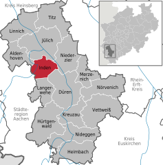


Inden is a municipality in the district of Düren in the state of North Rhine-Westphalia, Germany. It is located on the river Inde, approx. 10 km north-west of Düren. In the area around Inden lignite is extracted in open-pit mines. Several hundreds of inhabitants have been resettled in the 1990s and 2000s because of these activities.[citation needed]
Town division[]
Districts:
- Frenz
- Inden/Altdorf
- Lamersdorf
- Lucherberg
- Schophoven
- Viehöven

Inden-Schophoven Müllenark mill
References[]
- ^ Wahlergebnisse in NRW Kommunalwahlen 2020, Land Nordrhein-Westfalen, accessed 19 June 2021.
- ^ "Bevölkerung der Gemeinden Nordrhein-Westfalens am 31. Dezember 2020" (in German). Landesbetrieb Information und Technik NRW. Retrieved 21 June 2021.
| show Towns and municipalities in Düren (district) |
|---|
| show Authority control |
|---|
This Düren district location article is a stub. You can help Wikipedia by . |
Categories:
- Municipalities in North Rhine-Westphalia
- Düren (district)
- Cologne region geography stubs