Iranian Plate
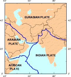
Location of the Iranian Plate near the boundaries between the Eurasian Plate and the Arabian/Indian plates
The Iranian Plate is a small tectonic plate thought to underlie Iran and Afghanistan, and parts of Iraq and Pakistan. It is compressed between the Arabian Plate to the southwest, the Eurasian Plate to the north, and the Indian Plate to the southeast. This compression is likely a cause for the very mountainous terrain of the area including the Zagros Mountains.
References[]
- William Bayne Fisher: The Middle East: a Physical, Social, and Regional Geography. Routledge 1978, ISBN 978-0-416-71520-0, p. 15–16
| Major |  | |
|---|---|---|
| Minor | ||
| Micro |
| |
| Historical | ||
| Oceanic ridges |
| |
| Ancient oceanic ridges | ||
This tectonics article is a stub. You can help Wikipedia by . |
Categories:
- Tectonic plates
- Geology of Afghanistan
- Geology of Iran
- Geology of Iraq
- Geology of Pakistan
- Tectonics stubs