Isabela de Sagua
Isabela de Sagua
Isabela | |
|---|---|
Village | |
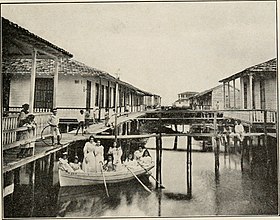 Houses of Isabela in early 20th century | |
| Nickname(s): La Venecia de Cuba | |
 Location of Isabela de Sagua in Cuba | |
| Coordinates: 22°56′21.5″N 80°00′45.4″W / 22.939306°N 80.012611°WCoordinates: 22°56′21.5″N 80°00′45.4″W / 22.939306°N 80.012611°W | |
| Country | |
| Province | Villa Clara |
| Municipality | Sagua la Grande |
| Founded | 1843[1] |
| Elevation | 5 m (16 ft) |
| Population (2011)[2] | |
| • Total | 3,187 |
| Time zone | UTC-5 (EST) |
| Area code(s) | +53-422 |

Isabela de Sagua, also shortened as Isabela and nicknamed La Venecia de Cuba ("The Cuban Venice"),[3] is a Cuban village and consejo popular ("people's council", i.e. hamlet) of the municipality of Sagua la Grande, in Villa Clara Province. In 2011 it had a population of 3,187.[2]
History[]
The village was founded in 1843 as the port and customs of Sagua and, 5 years later, it was enabled for international import trade.[1] Hurricane Kate (1985) severely damaged the village, which had to be largely rebuilt.[3]
Geography[]
Located on a peninsula, west of Sagua la Grande River mouth and by a lagoon, Isabela lies by the Atlantic Coast, in front of the Jardines del Rey archipelago. It is surrounded by a marsh, that spans around the peninsula.[4]
It is 11 km from Nueva Isabela, 17 from Sagua, 27 from the Mogotes de Jumagua, 36 from Cifuentes and 66 from Santa Clara.
Transport[]
Isabela de Sagua has a port on the northwestern shore and a marina in the southwestern one. Its railway station is the northern terminus of the Santa Clara-Sagua-Isabela line and has some tracks serving the port. A provincial road links the village to Sagua la Grande and to the "Circuito Norte" (CN) highway.
See also[]
References[]
- ^ a b (in Spanish) Isabela de Sagua (history) on EcuRed
- ^ a b (in Spanish) Isabela de Sagua on EcuRed
- ^ a b "Isabela de Sagua - the ruins of a Cuban Venice that slowly rises from the ashes". cubaholidays.co.uk, 14-3-2018
- ^ 3325910686 Isabela de Sagua on OpenStreetMap
External links[]
| Wikimedia Commons has media related to Isabela de Sagua. |
- (in Spanish) Isabela de Sagua (and history) on EcuRed
- Isabela de Sagua Destination Guide on trip-suggest.com
- Isabela de Sagua Weather on accuweather.com
- Sagua la Grande
- Populated places in Villa Clara Province
- Populated places established in 1843