Isezakichō
:Isezakicho is a district in Yokohama. For the city in Gunma Prefecture, see Isesaki, Gunma.
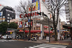
Isezakichō (伊勢佐木町) is a district of Naka Ward in Yokohama, Japan, consisting mainly of the Isezakichō Shopping Street (伊勢佐木町商店街, Isezakichō shōtengai). The shopping street is 1.2 km long, running from Isezakicho 1-chōme (-1丁目, -icchōme) in the northeast, to Isezakicho 7-chōme (-7丁目, -nanachōme) in the southwest.
Isezaki Mall is a special designation given to the 1-chōme (1丁目, icchōme) and 2-chōme (2丁目, nichōme) portions only, which is a car-free zone. The largest shops and businesses are in the Isezaki Mall area in the northeast end, closer to Kannai Station. As you walk along the Isezakicho Shopping Street towards 7-chōme in the southwest end, the shops become gradually smaller and the pedestrian traffic tapers off. On the other end, walking past the northeast end of Isezakicho, across towards Kannai Station, the street continues into the Bashamichi Street.
Until the 1960s, Isezakicho was the only large shopping area in Yokohama catering to local residents. But that was before Motomachi and the Yokohama Station area became more popular. Motomachi had previously catered mainly to foreign residents, while the Yokohama Station developed into a large shopping area only in the 1970s. Today, Isezakicho continues to be one of the major shopping areas of Yokohama.
Isezakichō is featured in the video game Yakuza: Like a Dragon as Isezaki Ijincho.[1]
Major Attractions[]
- Yurindo Bookstore, Main Location [1]
- Fujiya [2] (This is the 2nd Fujiya restaurant ever opened. The 1st store in Motomachi no longer exists.)
References[]
- This article was translated from the corresponding article in the Japanese Wikipedia, retrieved on September 10, 2006, and with a few minor changes.
- ^ Boudreau, Ian (4 November 2020). "Yakuza: Like a Dragon review – kill 'em with kindness". PCGamesN. Retrieved 11 July 2021.
External links[]
- (in Japanese) Isezaki Mall (official website), 1-chōme & 2-chōme
- (in Japanese) Isezakicho Shopping Street (official website), 3-chōme through 7-chōme
| Wikimedia Commons has media related to Isezaki-chō. |
Coordinates: 35°26′37″N 139°37′53″E / 35.44361°N 139.63139°E

This Kanagawa Prefecture location article is a stub. You can help Wikipedia by . |
- Neighborhoods of Yokohama
- Shopping districts and streets in Japan
- Kanagawa geography stubs