Ishim (river)
| Ishim | |
|---|---|
 The river Ishim in Nur-Sultan, a popular thoroughfare in the winter when it is frozen over. | |
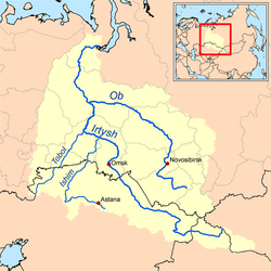 Map of the Ob–Irtysh drainage basin showing the Ishim River | |
| Location | |
| Country | Kazakhstan, Russia |
| Physical characteristics | |
| Mouth | Irtysh |
• coordinates | 57°41′53″N 71°11′51″E / 57.6981°N 71.1975°ECoordinates: 57°41′53″N 71°11′51″E / 57.6981°N 71.1975°E |
| Length | 2,450 km (1,520 mi) |
| Basin size | 177,000 km2 (68,000 sq mi) |
| Discharge | |
| • average | 56.3 m3/s (1,990 cu ft/s) |
| Basin features | |
| Progression | Irtysh→ Ob→ Kara Sea |

The Ishim (Russian: Иши́м, romanized: Ishim; Kazakh: Есіл, romanized: Esil) is a river running through Kazakhstan and Russia. It is 2,450 kilometres (1,520 mi) long, and has a drainage basin of 177,000 square kilometres (68,000 sq mi).[1] Its average discharge is 56.3 cubic metres per second (1,990 cu ft/s). It is a left tributary of the Irtysh. The Ishim is partly navigable in its lower reaches. The upper course of the Ishim passes through Nur-Sultan, the capital of Kazakhstan. In Russia, the river travels through a vast marshland for its course, and has countless meanders and oxbow lakes. The river freezes from late November until March.
Main tributaries[]
The largest tributaries of the Ishim are, from source to mouth:
- Qalqutan (right)
- (right)
- Terisaqqan (left)
- Aqqanburlyq (right)
- (left)
- (right)
In Nur-Sultan[]
According to the President of Kazakhstan, Nursultan Nazarbayev, Nur-Sultan (formerly Astana) was chosen as the capital in part due to the presence of the river. The city is also divided into two sections, the Right (northern) Bank of the Ishim or the old town, and the Left (southern) Bank, where the new government buildings such as the Ak Orda, the House of the Government, and the Supreme Court are located, as well as many prestigious apartment and living complexes.
Since 1998, the Ishim in Nur-Sultan has been actively managed, for flood management and maintaining water level, in order to provide for recreational use and ensure the showpiece appearance. It is dammed downstream of central Nur-Sultan, keeping its level higher than it otherwise would be most of the time, while the river bottom has been made deeper, in order to let flood waters through faster. In central Nur-Sultan, near the city park, there is now a public beach and pedalo boat rental; meanwhile, if the river had not been dammed, "citizens would have been able to walk across it".[2][3] Another dam will be constructed upstream of the city, for better flood control.
The city authorities also have plans for further deepening the river, which will eventually allow small passenger boats to operate on a 22-kilometre (14 mi) section of the river through the nation's capital.[3]
To maintain the desired level of water flow, water is pumped to the Ishim from the Irtysh, over the Irtysh–Karaganda Canal and a pipeline.
See also[]
References[]
- ^ Река ИШИМ in the State Water Register of Russia (Russian)
- ^ Реки, каналы, мосты, набережные Archived 2007-10-12 at the Wayback Machine (Rivers, Canals, Bridges, Embankments). The official site of the city of Nur-Sultan. (in Russian)
| Wikimedia Commons has media related to Ishim River. |
| Authority control |
|---|
- Tributaries of the Irtysh
- Rivers of Kazakhstan
- Rivers of Tyumen Oblast
- Rivers of Omsk Oblast
- International rivers of Asia