Island Lake, Algoma District
Island Lake | |
|---|---|
 | |
 Island Lake Location of Island Lake in Ontario | |
| Coordinates: 46°40′41″N 84°15′51″W / 46.67806°N 84.26417°WCoordinates: 46°40′41″N 84°15′51″W / 46.67806°N 84.26417°W | |
| Country | Canada |
| Province | Ontario |
| Region | Northeastern Ontario |
| District | Algoma |
| Municipality | Algoma, Unorganized, North Part |
| Elevation | 334 m (1,096 ft) |
| Time zone | UTC-5 (Eastern Time Zone) |
| • Summer (DST) | UTC-4 (Eastern Time Zone) |
| FSA | P0S |
| Area code(s) | 705 |

Island Lake is a settlement in the Unorganized North Part of Algoma District in northeastern Ontario, Canada. It is part of the Aweres local services board and is about 5 kilometres (3 mi) northeast of the community of Heyden on Ontario Highway 17. The settlement is at the junction of Ontario Highway 552 and Ontario Highway 556, and the Algoma Central Railway passes through the community.
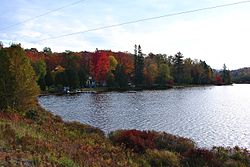
Island Lake lies on the shores of Upper Island Lake and Lower Island Lake; the Upper Island Lake Dam controls the flow from the former to the latter, and the waters flow via the Root River to the St. Marys River.
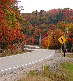
Highway 556 at Island Lake
References[]
- "Island Lake". Geographical Names Data Base. Natural Resources Canada. Retrieved 2010-07-24.
- "Topographic Map sheet 41K9". Atlas of Canada. Natural Resources Canada. 2010-02-04. Archived from the original on 2010-08-03. Retrieved 2010-07-24.

This Northern Ontario geographical article is a stub. You can help Wikipedia by . |
Categories:
- Communities in Algoma District
- Northern Ontario geography stubs