Laird, Ontario
Laird | |
|---|---|
Township (single-tier) | |
| Township of Laird | |
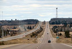 Highway 17 through Laird Township | |
 Laird | |
| Coordinates: 46°23′N 84°04′W / 46.383°N 84.067°WCoordinates: 46°23′N 84°04′W / 46.383°N 84.067°W | |
| Country | Canada |
| Province | Ontario |
| District | Algoma |
| Settled | 1874 |
| Incorporated | 1891 |
| Government | |
| • Mayor | Dick Beitz |
| • MP | Carol Hughes (NDP) |
| • MPP | Michael Mantha (NDP) |
| Area | |
| • Land | 102.48 km2 (39.57 sq mi) |
| Population (2016)[1] | |
| • Total | 1,047 |
| • Density | 10.2/km2 (26/sq mi) |
| Time zone | UTC-5 (EST) |
| • Summer (DST) | UTC-4 (EDT) |
| Postal Code | P0S |
| Area code(s) | 705 and 249 |
| Website | www.lairdtownship.ca |

Laird is a township and village in the Algoma District in Northern Ontario, Canada. The township had a population of 1,047 in the Canada 2016 Census, down from 1,057 in the 2011 census.
Communities[]
The township includes the named communities of Laird and Neebish. It also includes a portion of Bar River, a small hamlet straddling the boundary between the townships of Laird and Macdonald, Meredith and Aberdeen Additional.
Demographics[]
| Canada census – Laird, Ontario community profile | |||
|---|---|---|---|
| 2016 | 2011 | 2006 | |
| Population: | 1,047 (-0.9% from 2011) | 1,057 (-1.9% from 2006) | 1,078 (5.6% from 2001) |
| Land area: | 102.48 km2 (39.57 sq mi) | 102.43 km2 (39.55 sq mi) | 101.77 km2 (39.29 sq mi) |
| Population density: | 10.2/km2 (26/sq mi) | 10.3/km2 (27/sq mi) | 10.6/km2 (27/sq mi) |
| Median age: | 48.1 (M: 47.5, F: 48.7) | 46.4 (M: 47.2, F: 46.1) | |
| Total private dwellings: | 527 | 610 | 640 |
| Median household income: | $87,680 | $69,862 | |
| References: 2016[2] 2011[3] 2006[4] earlier[5] | |||
Population trend:[6]
- Population in 2016: 1,047
- Population in 2011: 1,057
- Population in 2006: 1,078
- Population in 2001: 1,021
- Population in 1996: 1,073
- Population in 1991: 997
Transportation[]
Highway 17 passes through the township. Tarbutt is a neighbour of Laird and is separated by a low-grade dirt road called "Townline Road" which spurs into a road to Pine Island.
See also[]
References[]
- ^ a b "Laird census profile". 2016 Census of Population. Statistics Canada. Retrieved 2019-06-04.
- ^ "2016 Community Profiles". 2016 Canadian Census. Statistics Canada. February 21, 2017. Retrieved 2019-06-04.
- ^ "2011 Community Profiles". 2011 Canadian Census. Statistics Canada. July 5, 2013. Retrieved 2012-02-17.
- ^ "2006 Community Profiles". 2006 Canadian Census. Statistics Canada. March 30, 2011. Retrieved 2011-04-14.
- ^ "2001 Community Profiles". 2001 Canadian Census. Statistics Canada. February 17, 2012.
- ^ Statistics Canada:1996, 2001, 2006, 2011 census
External links[]
| Wikimedia Commons has media related to Laird, Ontario. |
Places adjacent to Laird, Ontario | ||||||||||||||||
|---|---|---|---|---|---|---|---|---|---|---|---|---|---|---|---|---|
| ||||||||||||||||

Categories:
- Municipalities in Algoma District
- Single-tier municipalities in Ontario
- Township municipalities in Ontario