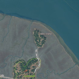
Jakes Island
 USGS aerial imagery of Jakes Island | |
 Jakes Island  Jakes Island  Jakes Island | |
| Geography | |
|---|---|
| Location | Northern California |
| Coordinates | 38°00′47″N 122°29′20″W / 38.01306°N 122.48889°W[1]Coordinates: 38°00′47″N 122°29′20″W / 38.01306°N 122.48889°W[1] |
| Adjacent bodies of water | San Francisco Bay |
| Highest elevation | 52 ft (15.8 m)[1] |
| Administration | |
United States | |
| State | |
| County | Marin |
Jakes Island is an island in San Francisco Bay. It is in Marin County, California. Its coordinates are 38°00′47″N 122°29′20″W / 38.01306°N 122.48889°W[1], and the United States Geological Survey gave its elevation as 52 ft (16 m) in 1999.[1] It appears on a 2015 United States Geological Survey map of the area.[2] Egrets can be seen there.[3]
References[]
- ^ a b c d U.S. Geological Survey Geographic Names Information System: Jakes Island
- ^ United States Geological Survey (2015). "Petaluma Point Quadrangle, California" (Map). United States Department of the Interior Geological Survey. 1:24000.
- ^ "Egret watching". The San Francisco Examiner. San Francisco, California. 1995-09-01. p. 66.
Map: Islands of the San Francisco Bay Area | |
|---|---|
 Alameda Bay Farm Brooks Hooks Red R. Skaggs Aramburu |

This Marin County, California–related article is a stub. You can help Wikipedia by . |
Categories:
- Islands of Marin County, California
- Islands of San Francisco Bay
- Islands of Northern California
- Marin County, California geography stubs