Jameln
Jameln | |
|---|---|
show Location of Jameln within Lüchow-Dannenberg district | |
 Jameln | |
| Coordinates: 53°02′32″N 11°04′43″E / 53.04222°N 11.07861°ECoordinates: 53°02′32″N 11°04′43″E / 53.04222°N 11.07861°E | |
| Country | Germany |
| State | Lower Saxony |
| District | Lüchow-Dannenberg |
| Municipal assoc. | Elbtalaue |
| Subdivisions | 10 Ortsteile |
| Government | |
| • Mayor | Udo Sperling |
| Area | |
| • Total | 35.84 km2 (13.84 sq mi) |
| Elevation | 19 m (62 ft) |
| Population (2020-12-31)[1] | |
| • Total | 1,101 |
| • Density | 31/km2 (80/sq mi) |
| Time zone | UTC+01:00 (CET) |
| • Summer (DST) | UTC+02:00 (CEST) |
| Postal codes | 29479 |
| Dialling codes | 05864 |
| Vehicle registration | DAN |
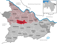


Jameln is a municipality in the district Lüchow-Dannenberg, in Lower Saxony, Germany. Jameln is part of the Samtgemeinde ("collective municipality") Elbtalaue.
Since the (municipality reform) in 1972, Jameln consists of ten villages:
- Breese im Bruche
- Breselenz
- Breustian
- Jameln
- Langenhorst
- Mehlfien
- Platenlaase
- Teichlosen
- Volkfien
- Wibbese

Breselenz
Additionally, there are three hamlets ():
- Hoheluft
- Jamelner Mühle
- Krammühle
Before 1972, Hoheluft belonged to Volkfien, Jamelner Mühle to Jameln and Krammühle to Breselenz.
The main village in the municipality is Jameln, with around 450 inhabitants.
Mathematician Bernhard Riemann (1826–1866) was born in Breselenz.
References[]
| show Towns and municipalities in Lüchow-Dannenberg (district) |
|---|
| show Authority control |
|---|
This Lüchow-Dannenberg location article is a stub. You can help Wikipedia by . |
Categories:
- Municipalities in Lower Saxony
- Lüchow-Dannenberg
- Lüneburg region geography stubs