January 2008 tornado outbreak
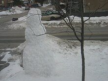
 EF3 tornado damage in Wheatland, Wisconsin. | |
| Type | Tornado outbreak |
|---|---|
| Duration | January 7–11, 2008 |
| Tornadoes confirmed | 72 confirmed |
| Max. rating1 | EF3 tornado |
| Duration of tornado outbreak2 | 3 days, 11 hours, 48 minutes |
| Fatalities | 4 fatalities, 62 injuries |
| Damage | $88 million (+ $41 million non–tornadic)[1] |
| Areas affected | Central and Southern United States |
| 1Most severe tornado damage; see Enhanced Fujita scale 2Time from first tornado to last tornado | |
The January 2008 tornado outbreak was an unseasonably strong tornado outbreak that began on January 7, 2008 and continued for nearly four days, with the hardest hit area being southwestern Missouri, northwestern Arkansas, and the surrounding area. In addition, a strong supercell in northern Illinois and southeastern Wisconsin produced that region's first January tornadoes since 1967.[2]
More tornadoes occurred across the Mississippi Valley on January 8 and after a break in the activity on January 9, another round of severe weather took place in the Southern United States (primarily Alabama and Mississippi) on January 10. Several damaging tornadoes were reported that day, although no one was killed. In total, over the four-day period, 72 tornadoes were confirmed and four people were killed.
Meteorological synopsis[]
An unseasonably warm air mass was entrenched over much of central and eastern North America with record highs for much of the region. Several record high temperatures were broken across several states and Canadian provinces from January 7 to January 9 as temperatures rose into the 70s (21–25 °C) as far north as the Ohio Valley with dewpoints in the high 50s and low 60s (14–17 °C) providing additional fuel for storm development.
In addition, many areas near the Great Lakes region reached the mid to upper 60s (17–20 °C) which allowed the northern cells to form, while several areas in southern Ontario and Quebec near the Canada-US border reached near 60 °F (16 °C).[3][4]

A strong low-pressure area over the central Great Lakes and its associated cold front combined with intense wind shear to provide a favorable environment for supercell development.[5] Despite only moderate instability (which meant only a slight risk of severe weather was issued by the Storm Prediction Center, and only modest probabilities for severe weather at first[6]), supercells developed throughout the day over much of the central US and continued throughout the evening and overnight hours, continuing into the morning of January 8. The hardest-hit area was in the Ozarks, around Springfield, Missouri, where nearly continuous supercells developed throughout the evening, resulting in numerous tornado touchdowns. In addition to the tornadoes, hail larger than baseballs and damaging straight-line downburst winds as strong as 100 mph (160 km/h) were reported. At least three people were killed in Missouri as a result of the tornadoes. Two of these deaths occurred near Marshfield and there were also six injuries.[7]
Strong tornadoes also touched down further north near Chicago and Milwaukee causing extensive damage along the Wisconsin/Illinois border as well as several injuries. Strong cells and lines also formed in Michigan prompting rare tornado warnings across central parts of Lower Michigan.[8] Scattered thunderstorms were reported in Northern, Central and Southern Ontario on the evening of January 7.[9] Tornado watches extended from eastern Oklahoma to southwestern Ontario on January 7.[10]

Activity shifted across the on January 8 where tornado watches were issued across Arkansas and Tennessee and later extended across the Ohio Valley to near Columbus, Ohio and Dayton, Ohio until the early morning hours on January 9. A strong tornado in Pope County, Arkansas killed person and additional tornadoes were reported just west of Memphis. During the day, most of the activity was formed into a line that extended from the Ohio Valley to Alabama although thunderstorm-related wind damage was reported as far north as upstate New York and western Pennsylvania.
After a lull in activity on January 9, a separate system across the Southern United States led to more severe weather, including tornadoes, on January 10. A moderate risk of severe weather was issued by the Storm Prediction Center.

Storms developed across Louisiana and Mississippi during the morning and noon periods moving into Alabama with additional storms developing as far north as central and eastern Kentucky where a tornado watch was issued stretching down towards eastern Louisiana and later into Georgia. Multiple strong tornadoes affected Mississippi, Tennessee, and Alabama that evening, including an EF3 that severely damaged the town of Caledonia, Mississippi. More stable air farther east reduced the severe weather potential. Wintry weather including snow, sleet and freezing rain on the northern side of the storm was reported from Wisconsin to Maine on January 10–11. Overall, this outbreak killed four people and injured at least 62 others.
Tornadoes confirmed[]
| EFU | EF0 | EF1 | EF2 | EF3 | EF4 | EF5 | Total |
|---|---|---|---|---|---|---|---|
| 0 | 29 | 28 | 7 | 8 | 0 | 0 | 72 |
January 7 event[]
| List of reported tornadoes – Monday, January 7, 2008 | ||||||
|---|---|---|---|---|---|---|
| EF# | Location | County | Time (UTC) | Path length | Damage | |
| Missouri | ||||||
| EF0 | SW of Lowry City | St. Clair | 2022 | unknown | Brief tornado damaged a few trees.[11] | |
| EF0 | SE of Lincoln | Benton | 2054 | unknown | A pole barn was heavily damaged.[12] | |
| EF0 | NE of Auxvasse | Audrain | 2155 | 0.5 mile (800 m) |
Tornado damaged a machine shed, along with numerous trees and tree limbs.[13] | |
| EF2 | N of Purdy | Barry | 2306 | 12 miles (19.2 km) |
Intermittent tornado passed between Purdy and Monett. Houses and farm buildings were damaged along the path, and eight mobile homes were destroyed at a mobile home park.[14] | |
| EF0 | E of Pineville | McDonald | 2350 | 0.1 mile (160 m) |
Tornado caused minor tree damage.[15] | |
| EF2 | Northern Republic to SW of Brookline | Greene | 2357 | 6 miles (9.6 km) |
Tornado impacted the northern part of Republic, where many homes were damaged, 15 of which sustained major damage or were destroyed. An Elementary School sustained major roof damage towards the end of the path before the tornado dissipated.[16] | |
| EF3 | W of Strafford to E of Abo | Greene, Webster, Laclede | 0029 | 26 miles (42 km) |
3 deaths – Tornado began west of Strafford and passed north of town, destroying several frame homes and outbuildings. Additional frame homes were destroyed near Marshfield, along with barns and mobile homes. A semi-truck was flipped as the tornado crossed Interstate 44, and severe damage occurred in the nearby ghost town of Sampson. Numerous additional homes and outbuildings were destroyed, and multiple injuries occurred near Lebanon before the tornado dissipated. Two of the fatalities occurred in frame homes, and the other occurred in a mobile home. Over 50 homes, mobile homes, and outbuildings were destroyed along the path, numerous power poles and large trees were snapped, and 18 people were injured.[17] | |
| EF0 | NE of Aurora | Lawrence, Christian | 0128 | 6 miles (9.6 km) |
Farmhouses and outbuildings were damaged along the path.[18] | |
| EF2 | SW of Strafford to W of Marshfeield | Greene, Webster | 0132 | 17 miles (29 km) |
Tornado tracked just south of the previous Strafford area EF3, paralleling Interstate 44 and crossing it several times. Homes and outbuildings were heavily damaged along the path.[19] | |
| EF0 | S of Mount Sterling | Gasconade | 0150 | 0.25 mile (400 m) |
Brief tornado touchdown caused tree damage.[20] | |
| EF3 | NW of Hooker to NE of Jerome | Pulaski, Phelps | 0206 | 7 miles (11 km) |
Near the beginning of the path, a few homes and several outbuildings were destroyed in rural areas. The tornado clipped the north side of Jerome before dissipating, where one home and multiple additional outbuildings were destroyed.[21] | |
| EF1 | NW of Mayflower | McDonald, Barry | 0215 | 7 miles (11.2 km) |
A few structures were heavily damaged or destroyed, along with numerous trees.[22] | |
| EF0 | W of Clarksville | Pike | 0230 | 5 miles (8 km) |
Intermittent tornado touchdown caused some tree damage.[23] | |
| EF1 | NE of Marshfield | Webster, Dallas | 0242 | 6 miles (9.6 km) |
One house was damaged along with a few outbuildings.[24] | |
| EF2 | NW of Phillipsburg | Laclede | 0300 | 5 miles (8 km) |
Several outbuildings were destroyed and one house was heavily damaged. Numerous trees were uprooted as well.[25] | |
| EF0 | W of Seligman | Barry | 0312 | 20 yds (18 m) |
Very short-lived tornado knocked a few trees down.[26] | |
| EF1 | NW of Highlandville | Christian | 0336 | 1.5 miles (2.4 km) |
Two mobile homes were destroyed and several houses were damaged. One person was injured by flying debris.[27] | |
| EF1 | W of Vichy | Phelps, Maries | 0340 | 13 miles (21 km) |
35 to 45 structures were damaged, with one home partially moved off its foundation and portions of the roof thrown up to a quarter of a mile away. Wind gusts of up to 84 knots were recorded by the Vichy Automated Weather Station, and a few airplanes were damaged nearby at the airport. A mobile home was destroyed as well and one person was injured.[28] | |
| EF0 | E of Rogersville to NE of Diggins | Webster | 0357 | 11 miles (17 km) |
Tornado caused minor damage to trees and outbuildings along its path.[29] | |
| EF1 | SW of | McDonald, Barry | 0421 | 9 miles (15 km) |
Tornado damaged trees and structures, a few of which were removed from their foundations.[30][31] | |
| Illinois | ||||||
| EF3 | N of Poplar Grove to NE of Lawrence | Boone, McHenry | 2130 | 13.2 miles (21 km) |
Tornado initially caused minor damage to trees and a shed before striking an apple orchard at EF2 strength, where large trees were snapped and uprooted, a large barn was destroyed, and other buildings were severely damaged. EF3 damage occurred at a nearby farmstead as a poorly-anchored farmhouse was swept away with only the basement remaining, and large trees on the property were denuded (though overall context was not consistent with a violent tornado). Hay bales were rolled through fields as well. The tornado weakened further along the path, causing minor EF0 and EF1 damage to farmhouses, trees, power lines, barns, and sheds. The tornado strengthened again, reaching EF2 strength as it struck the small town of Lawrence, where extensive tree damage occurred, a house had more than half its roof torn off and its detached garage destroyed, other homes sustained shingle damage, and a train carrying hazardous materials was derailed, resulting in an evacuation of the town. Past Lawrence, the tornado overturned a semi-truck and caused EF1 damage to barns and trees before dissipating. It was the first tornado in northeastern Illinois in the month of January since 1950. Five people were injured.[32][33] | |
| EF1 | S of Mackinaw | Tazewell | 2322 | 3 miles (4.8 km) |
Tornado destroyed a pole barn and damaged a house, along with a few outbuildings. In addition, a chain link fence and a few tree limbs were blown down.[34] | |
| EF0 | SE of Pleasant Hill | Pike | 0240 | 2.75 miles (4.4 km) |
Intermittent tornado caused some tree damage.[35] | |
| Wisconsin | ||||||
| EF3 | SE of Walworth to NW of Paddock Lake | Walworth, Kenosha | 2202 | 10.8 miles (17 km) |
This was the northernmost January tornado in the US since 1967. Near Walworth, the tornado uprooted trees and caused minor EF1 damage to homes and outbuildings. The tornado rapidly intensified to high-end EF3 strength, tearing through multiple subdivisions as it struck Wheatland, where 25 homes were destroyed, 27 sustained major damage, 25 sustained minor damage, and 7 were affected in some way. Further along the path, the tornado impacted the small town of Brighton, where 4 homes were destroyed, 3 sustained major damage, 3 sustained minor damage, and 10 were affected in some way. A large barn was destroyed before the tornado dissipated near Paddock Lake. Numerous large trees were snapped and denuded along the path, and 15 people were injured. Some of the homes destroyed were leveled, though they were poorly anchored and context did not support a rating higher than EF3.[36][37] | |
| EF1 | Northern Kenosha | Kenosha | 2239 | 2.4 miles (3.9 km) |
Rope tornado tracked through the northern part of Kenosha. 5 homes were left uninhabitable, 6 sustained major damage, and 21 others sustained minor damage. Power lines were toppled and numerous trees were snapped or uprooted as well.[38] | |
| Arkansas | ||||||
| EF0 | S of Hiwasse | Benton | 0205 | unknown | Brief tornado remained over open country, causing no damage.[39] | |
| EF0 | E of Centerton | Benton | 0250 | unknown | Brief tornado remained over open country, causing no damage.[40] | |
| EF1 | SW of Decatur | Benton | 0509 | 2.6 miles (4.2 km) |
Tornado caused extensive tree damage.[41] | |
| Oklahoma | ||||||
| EF0 | SW of Watts | Adair | 0208 | unknown | Brief tornado remained over open country, causing no damage.[42] | |
| EF0 | N of Moodys | Cherokee | 0428 | unknown | Tornado caused roof damage to homes, damaged several barns, and uprooted trees.[43] | |
| EF0 | NE of Porter | Wagoner | 0538 | 1 miles (1.6 km) |
Tornado caused extensive tree damage.[44] | |
| EF0 | NE of Wagoner | Wagoner | 0554 | 2.7 miles (4.4 km) |
Tornado caused extensive tree damage.[44] | |
| Sources: Storm reports of January 7, 2008, NWS Milwaukee, NWS Springfield, KY3 News, NWS Chicago, NWS St. Louis, NWS Tulsa | ||||||
January 8 event[]
| List of reported tornadoes – Tuesday, January 8, 2008 | ||||||
|---|---|---|---|---|---|---|
| EF# | Location | County | Time (UTC) | Path length | Damage | |
| Missouri | ||||||
| EF1 | NE of Washburn | Barry | 0822 | 7 miles (11 km) |
Several houses and outbuildings were damaged, along with numerous trees.[45] | |
| EF1 | E of Cassville | Barry, Stone | 0831 | 14 miles (22 km) |
Several poultry barns, sheds, and outbuildings were heavily damaged or destroyed, and numerous trees were downed.[46] | |
| EF1 | Springfield | Greene | 0837 | 1 mile (1.6 km) |
Tornado moved through the northern part of downtown Springfield, causing a warehouse to collapse. Several homes sustained minor damage, and a Krispy Kreme sign was destroyed.[47] | |
| EF1 | Highlandville | Christian | 0850 | 5 miles (8 km) |
Tornado tracked through town, damaging several homes and a church. Several outbuildings and highway signs were destroyed as well.[48] | |
| EF0 | Branson to Hollister | Taney | 0901 | 2.88 miles (90 m) |
Tornado touched down at the Thousand Hills Resort in Branson, damaging three condominiums. In Hollister, a mobile home park was damaged.[49] | |
| EF0 | SW of Bracken to SW of Susanna | Webster | 0916 | 7 miles (11.2 km) |
Tornado embedded in a squall line caused minor tree and structure damage.[50] | |
| EF0 | SW of Tigris to SE of Mount Zion | Douglas | 0917 | 10 miles (16 km) |
Barns and outbuildings were damaged or destroyed, and multiple trees were uprooted or snapped.[51] | |
| EF2 | S of Niangua | Webster | 0918 | 5 miles (8 km) |
Several homes and outbuildings were destroyed.[52] | |
| EF1 | SW of Mountain Grove | Douglas | 0943 | 1.5 miles (2.4 km) |
One mobile home was moved from its foundation, a barn and some outbuildings were damaged, and significant tree damage occurred.[53] | |
| EF1 | SE of Dawson to SE of Bado | Wright, Texas | 0945 | 12 miles (19.2 km) |
A few barns and outbuildings were damaged along the path.[54] | |
| EF0 | W of West Plains | Howell | 1020 | unknown | Brief tornado damaged two outbuildings and a mobile home.[55] | |
| EF1 | SW of Eminence | Shannon | 1027 | 1.5 miles (2.4 km) |
Numerous trees were snapped or uprooted, but no structures were impacted along the path.[56] | |
| EF1 | NE of Eminence | Shannon | 1038 | 10 miles (16 km) |
Two barns and a garage were destroyed, and another barn was damaged. Numerous trees were snapped or uprooted as well.[57] | |
| EF0 | SW of Alton | Oregon | 1059 | 1 mile (1.6 km) |
Tornado damaged a few outbuildings south of Alton. A motorcycle shop sustained the most damage as a barn that sheltered several new motorcycles was destroyed.[58] | |
| EF1 | NE of Essex | Stoddard | 1840 | 4.2 miles (6.8 km) |
One house was heavily damaged, with part of the roof torn off and debris scattered 100 to 200 yards. Three outbuildings and an equipment shed were destroyed, and a trailer was thrown about 75 yards. Approximately ten power poles were snapped in half, vehicle windows were blown out, and a few large trees were snapped. A pump house was blown into a propane tank, causing a propane leak as well.[59] | |
| Arkansas | ||||||
| EF2 | SW of Appleton to W of | Pope, Conway, Van Buren | 1440 | 20.5 miles (33 km) |
1 death – Major damage occurred near Appleton, with 42 homes damaged in that area. Of these, seven were destroyed, six had minor damage, and the rest had moderate to heavy damage. In addition, six chicken houses, two barns, and a number of outbuildings were destroyed, a travel trailer and motor home were overturned, and hundreds of trees were blown down. A man was killed when his mobile home was destroyed in this area. Near Jerusalem, 3 homes were destroyed, and 12 others suffered damage ranging from light to heavy. Ten other structures, such as chicken houses and barns were destroyed, with 13 such structures damaged. A church was destroyed and an adjacent cemetery was damaged in this area as well. Three natural gas well sites were also damaged but there was no release of gas. The tornado moved into the Ozark National Forest, where hundreds of trees were blown down before it dissipated. Two other people were injured.[60] | |
| EF0 | SE of to SE of Twist | Cross | 1926 | 11 miles (17.6 km) |
A mobile home lost its roof, irrigation sprinklers were blown over, and trees and power lines were knocked down.[61] | |
| EF1 | S of | Poinsett | 1952 | 250 yds (225 m) |
Brief touchdown damaged two houses and destroyed a shed. Numerous trees were downed and debris was scattered across a nearby field.[62] | |
| EF1 | S of Osceola | Mississippi | 2020 | 3.5 miles (5.6 km) |
Numerous home sustained roof damage and many trees were downed. A metal farm equipment building was shifted from its foundation, and a vehicle was destroyed as well.[63] | |
| Tennessee | ||||||
| EF1 | NE of to NW of Bonicord | Lauderdale, Dyer | 2058 | 7 miles (11 km) |
Multiple homes were damaged, including two that had their roofs blown off, one of which was shifted off of its foundation. Outbuildings, fences, garages, and machine sheds were destroyed as well. A mobile home was also destroyed, and many trees and power lines were downed.[64] | |
| Mississippi | ||||||
| EF0 | S of Church Hill | Jefferson | 2130 | 4 miles (6.4 km) |
Trees were downed in a convergent pattern.[65] | |
| EF1 | NW of Harrisville to E of | Simpson | 2337 | 20 miles (32 km) |
A house had a large section of its roof torn off, and nearby outbuilding was blown away and destroyed. Another home and several outbuildings sustained lesser damage. Extensive tree damage occurred along the path.[66] | |
| EF0 | SE of Puckett | Rankin | 0011 | unknown | Several trees were downed and a home sustained shingle damage.[67] | |
| Sources: Storm reports of January 8, 2008, NWS Little Rock, NWS Paducah, NWS Jackson (MS), NWS Memphis | ||||||
January 10 event[]
| List of reported tornadoes – Thursday, January 10, 2008 | ||||||
|---|---|---|---|---|---|---|
| EF# | Location | County/ Parish |
Time (UTC) | Path length | Damage | |
| Mississippi | ||||||
| EF1 | SE of Rocky Springs | Claiborne | 1727 | 4 miles (6.4 km) |
Tornado snapped and uprooted hundreds of trees in a rural area. Power lines were downed as well.[68] | |
| EF3 | SW of Goodman to SW of | Holmes, Attala, | 1751 | 10 miles (16 km) |
Large wedge tornado initially caused minor to moderate tree damage and tore a section of roof from a house before reaching maximum intensity near Goodman. Multiple mobile homes were obliterated and vehicles were thrown, including a pickup truck that was tossed 150 yards. Two wood-frame homes had their roofs torn off and sustained total collapse of most of their cinder-block exterior walls, and three steel high-tension power poles were snapped off at their bases along Highway 51. Hundreds of trees in the area were snapped, denuded, and partially debarked as well. Additional less intense tree damage occurred near Boyette before the tornado dissipated. Three people were injured.[69] | |
| EF3 | W of Ethel SE of Ackerman | Attala, Choctaw | 1828 | 24 miles (38 km) |
Large wedge tornado snapped hundreds of trees near Ethel before causing considerable damage to structures near McCool, where a cinder-block building was mostly destroyed by a mixture of wind and falling trees, and a frame home had an added-on room ripped off. Other structures in the area sustained lesser damage. The tornado momentarily weakened and narrowed, causing only tree damage before re-intensifying as it struck a dairy farm near Weir, where 300 cattle were injured, ten fatally. A well-built milking parlor building at this location was destroyed with all masonry exterior walls collapsed, and numerous wood and metal livestock buildings were completely destroyed along with a grain bin. Additional tree damage occurred further along the path before the tornado dissipated. Three people were injured.[70] | |
| EF0 | N of Fannin | Rankin | 1839 | 1.5 miles (2.4 km) |
Tornado damaged some pine trees.[71] | |
| EF0 | SW of Pearl River Resort | Neshoba | 1942 | 2 miles (3.2 km) |
One home sustained damage to its porch, while another home had shingles torn off. Two outbuildings lost their roofs, and several trees were snapped and uprooted.[72] | |
| EF1 | S of Iuka | Tishomingo | 1954 | 3.5 miles (5.6 km) |
Tornado tore metal panels off of two large sheds, caused minor damage to two homes, and snapped and uprooted numerous trees.[73] | |
| EF3 | W of Kolola Springs, MS to NE of | Lowndes, Lamar (AL) | 2013 | 14 miles (22.4 km) |
At the beginning of the path, a house, a shed, and several trees and power poles were damaged. The tornado then intensified as a shed was completely destroyed, and a combine stored inside was thrown into trees nearby. The tornado reached its maximum strength as it struck Caledonia, resulting in major damage. Multiple homes lost roofs and exterior walls, some of which were shifted off of their foundations. A church was completely destroyed, another church sustained minor damage, and a daycare center sustained major damage. A school building in town was severely damaged, including the destruction of its gymnasium. A nearby Vocational Tech building was almost completely destroyed, and several vehicles including a school bus were thrown into the structure. Cars in the school parking lot were tossed up to 100 yards away and mangled, and several school buses were damaged, one of which lifted and deposited onto the roof of the school. The tornado exited Caledonia, and several homes had roofs torn off and exterior walls collapsed further along the path. A horse stable was destroyed, and a large metal high-tension truss tower was toppled as well. Several mobile homes were destroyed and vehicles were tossed 50 yards away in this area. Tree damage occurred before the tornado crossed into Alabama at EF2 strength, where mobile homes were destroyed, two homes had their roofs torn off, two wooden barns were destroyed, and large trees were uprooted before the tornado dissipated. 11 people were injured.[74] | |
| EF1 | NW of | Noxubee | 2058 | 1.5 mile (2.4 km) |
Five power poles were downed, two of which were snapped.[75] | |
| EF0 | N of | Noxubee | 2102 | 1 mile (1.6 km) |
A few tree tops and tree limbs were snapped.[76] | |
| Alabama | ||||||
| EF0 | W of Dixons Mills | Marengo | 1908 | 800 yds (750 m) |
Several trees were snapped and four homes sustained minor damage.[77] | |
| EF0 | SE of Pickensville | Pickens | 2140 | unknown | Brief tornado damaged a metal store barn and downed several small trees.[78] | |
| EF1 | E of Gordo | Pickens, Tuscaloosa | 2145 | 1.76 miles (2.8 km) |
One barn was destroyed and numerous chicken houses were damaged. Minor tree damage occurred as well.[79] | |
| EF3 | Windham Springs to | Tuscaloosa | 2220 | 4.9 miles (7.8 km) |
In Windham Springs, a church was destroyed and trees were snapped, a few of which were found with nails and wooden splinters embedded into their trunks. A general store was destroyed in the rural community of Wiley, with nearby vehicles flipped and one building on the property swept away. A credit card was found speared into a drink cooler at the general store as well.[80] | |
| Louisiana | ||||||
| EF1 | W of New Roads | Pointe Coupee | 1910 | 0.25 mile (400 m) |
Tornado damaged several industrial buildings, with windows broke, large metal doors blown in, and large sections of roof torn off. Debris was scattered up to a quarter-mile away, and a railroad crossing arm was broken as well.[81] | |
| Kentucky | ||||||
| EF1 | SW of Park City | Barren | 2002 | 1.8 miles (3 km) |
Tornado snapped and uprooted trees, destroyed 8 barns, caused minor roof damage to a home, and tore the porch off of another home.[82] | |
| Tennessee | ||||||
| EF2 | E of Waynesboro | Wayne | 2055 | 1.29 miles (2.1 km) |
Numerous trees were downed and a large metal barn was completely destroyed, with sheets of metal found in trees half a mile away. Other barns had their roofs torn off, an anchored dog house was blown away, a wooden plank was speared into the ground, and several homes had shingles torn off.[83] | |
| Sources: Storm reports of January 10, 2008 NWS Birmingham, NWS New Orleans, NWS Jackson (MS),
NWS Jackson (MS) Preliminary Storm Report, NWS Nashville, NWS Louisvlle | ||||||
January 11 event[]
| List of reported tornadoes – Friday, January 11, 2008 | ||||||
|---|---|---|---|---|---|---|
| EF# | Location | County/ Parish |
Time (UTC) | Path length | Damage | |
| Alabama | ||||||
| EF1 | S of Blue Springs | Barbour | 0700 | 3.5 miles (5.6 km) |
Four houses and a mobile home were damaged, and trees were uprooted. Flying debris punctured a hole in the roof of one home.[84] | |
| Sources: NWS Birmingham | ||||||
Non-tornadic events[]
The storm system was also responsible for heavy flooding rains across much of the Midwest from Michigan to Missouri as well as dense fog across Wisconsin, Ontario and Quebec which was caused by rapid snow melt stemming from the January thaw.[85] flooding was reported across several towns and roads which forced the evacuation of some residents. Record-breaking temperatures were reported all across Southern Ontario and surrounding areas.[86][87][88][89][90][91][92][93][94][95][96] The thick fog lead to numerous accidents including two pile-ups involving in total 100 vehicles on Interstate 90 near Madison, Wisconsin which killed at least two and injured dozens more while additional fatal accidents occurred elsewhere.[97] It also disrupted air travel across several airports.[98] Rainfall had exceeded locally 4 inches (100 mm) of rain from Missouri to Indiana and Michigan.
High winds and rain have battered Central, southern and eastern Ontario and southern and central Quebec on January 8, and 9. Power outages and wind damages were reported in some areas. As much as 140,000 Hydro One customers were without power in Ontario and at least 100,000 Hydro-Québec customers in Quebec. Winds were gusting in near on in excess of 100 km/h in some localities including the Greater Toronto Area while the highest peak being 133 km/h recorded near Sandbanks Provincial Park in Prince Edward County. One tractor trailer was overturned and nearly fell into the Saint Lawrence River on the Ogdensburg-Prescott International Bridge[99][100][101][102][103]
See also[]
| Wikimedia Commons has media related to January 2008 tornado outbreak sequence. |
- 1967 St. Louis tornado outbreak – Similar rare tornado outbreak in January in the Midwest
- List of North American tornadoes and tornado outbreaks
- List of tornadoes striking downtown areas
- Tornadoes of 2008
References[]
- ^ "Storm Events". Storm Event Database. National Climatic Data Center (NCDC). January 10, 2008. Archived from the original on August 13, 2008. Retrieved June 19, 2008.
- ^ "January Twisters Hit Southeastern Wisconsin". Associated Press. January 7, 2008. Archived from the original on January 17, 2008. Retrieved June 19, 2008.
- ^ "Ontario, CA". The Sudbury Star. Retrieved January 1, 2012.[permanent dead link]
- ^ "Timmins Daily Press – Ontario, CA". Timminspress.com. Retrieved January 1, 2012.[permanent dead link]
- ^ "Storm Prediction Center Jan 7, 2008 1300 UTC Day 1 Convective Outlook". Spc.noaa.gov. Retrieved January 1, 2012.
- ^ "Storm Prediction Center Jan 7, 2008 0600 UTC Day 1 Convective Outlook". Spc.noaa.gov. Retrieved January 1, 2012.
- ^ "Cleanup After Fatal Mo. Tornadoes Begins – Kansas City News Story – KMBC Kansas City". Kmbc.com. January 7, 2008. Archived from the original on February 23, 2012. Retrieved January 1, 2012.
- ^ "Mt. Pleasant Morning Sun". Themorningsun.com. Archived from the original on March 27, 2012. Retrieved January 1, 2012.
- ^ "The North Bay Nugget – Ontario, CA". Nugget.ca. Retrieved January 1, 2012.[permanent dead link]
- ^ Windsor, The (January 7, 2008). "Tornado watch in effect for Windsor-Essex County". Canada.com. Archived from the original on November 5, 2012. Retrieved January 1, 2012.
- ^ Storm Events Database - Event Details | National Centers for Environmental Information
- ^ Storm Events Database - Event Details | National Centers for Environmental Information
- ^ Storm Events Database - Event Details | National Centers for Environmental Information
- ^ Storm Events Database - Event Details | National Centers for Environmental Information
- ^ Storm Events Database - Event Details | National Centers for Environmental Information
- ^ Storm Events Database - Event Details | National Centers for Environmental Information
- ^ Storm Events Database - Event Details | National Centers for Environmental Information
- ^ Storm Events Database - Event Details | National Centers for Environmental Information
- ^ Storm Events Database - Event Details | National Centers for Environmental Information
- ^ Storm Events Database - Event Details | National Centers for Environmental Information
- ^ Storm Events Database - Event Details | National Centers for Environmental Information
- ^ Storm Events Database - Event Details | National Centers for Environmental Information
- ^ Storm Events Database - Event Details | National Centers for Environmental Information
- ^ Storm Events Database - Event Details | National Centers for Environmental Information
- ^ Storm Events Database - Event Details | National Centers for Environmental Information
- ^ Storm Events Database - Event Details | National Centers for Environmental Information
- ^ Storm Events Database - Event Details | National Centers for Environmental Information
- ^ Storm Events Database - Event Details | National Centers for Environmental Information
- ^ Storm Events Database - Event Details | National Centers for Environmental Information
- ^ "NWS SGF Jan 08 2008 Tornadoes". Archived from the original on January 17, 2008.
- ^ Storm Events Database - Event Details | National Centers for Environmental Information
- ^ "Tornadoes of January 7, 2008". Crh.noaa.gov. Retrieved January 1, 2012.
- ^ Storm Events Database - Event Details | National Centers for Environmental Information
- ^ Storm Events Database - Event Details | National Centers for Environmental Information
- ^ Storm Events Database - Event Details | National Centers for Environmental Information
- ^ "January 7, 2008 Tornado". Archived from the original on January 21, 2008.
- ^ Storm Events Database - Event Details | National Centers for Environmental Information
- ^ Storm Events Database - Event Details | National Centers for Environmental Information
- ^ Storm Events Database - Event Details | National Centers for Environmental Information
- ^ Storm Events Database - Event Details | National Centers for Environmental Information
- ^ Storm Events Database - Event Details | National Centers for Environmental Information
- ^ Storm Events Database - Event Details | National Centers for Environmental Information
- ^ Storm Events Database - Event Details | National Centers for Environmental Information
- ^ a b Storm Events Database - Event Details | National Centers for Environmental Information
- ^ Storm Events Database - Event Details | National Centers for Environmental Information
- ^ Storm Events Database - Event Details | National Centers for Environmental Information
- ^ Storm Events Database - Event Details | National Centers for Environmental Information
- ^ Storm Events Database - Event Details | National Centers for Environmental Information
- ^ Storm Events Database - Event Details | National Centers for Environmental Information
- ^ Storm Events Database - Event Details | National Centers for Environmental Information
- ^ Storm Events Database - Event Details | National Centers for Environmental Information
- ^ Storm Events Database - Event Details | National Centers for Environmental Information
- ^ Storm Events Database - Event Details | National Centers for Environmental Information
- ^ "Storm Events Database - Event Details | National Centers for Environmental Information".
- ^ "Storm Events Database - Event Details | National Centers for Environmental Information".
- ^ "Storm Events Database - Event Details | National Centers for Environmental Information".
- ^ "Storm Events Database - Event Details | National Centers for Environmental Information".
- ^ "Storm Events Database - Event Details | National Centers for Environmental Information".
- ^ "Storm Events Database - Event Details | National Centers for Environmental Information".
- ^ "Storm Events Database - Event Details | National Centers for Environmental Information".
- ^ "Storm Events Database - Event Details | National Centers for Environmental Information".
- ^ "Storm Events Database - Event Details | National Centers for Environmental Information".
- ^ "Storm Events Database - Event Details | National Centers for Environmental Information".
- ^ "Storm Events Database - Event Details | National Centers for Environmental Information".
- ^ "Storm Events Database - Event Details | National Centers for Environmental Information".
- ^ "Storm Events Database - Event Details | National Centers for Environmental Information".
- ^ "Storm Events Database - Event Details | National Centers for Environmental Information".
- ^ "Storm Events Database - Event Details | National Centers for Environmental Information".
- ^ "Storm Events Database - Event Details | National Centers for Environmental Information".
- ^ "Storm Events Database - Event Details | National Centers for Environmental Information".
- ^ "Storm Events Database - Event Details | National Centers for Environmental Information".
- ^ "Storm Events Database - Event Details | National Centers for Environmental Information".
- ^ "Storm Events Database - Event Details | National Centers for Environmental Information".
- ^ "Storm Events Database - Event Details | National Centers for Environmental Information".
- ^ "Storm Events Database - Event Details | National Centers for Environmental Information".
- ^ "Storm Events Database - Event Details | National Centers for Environmental Information".
- ^ "Storm Events Database - Event Details | National Centers for Environmental Information".
- ^ "Storm Events Database - Event Details | National Centers for Environmental Information".
- ^ "Storm Events Database - Event Details | National Centers for Environmental Information".
- ^ "Windham Springs Tornado - January 10, 2008". Archived from the original on April 2, 2015.
- ^ "Storm Events Database - Event Details | National Centers for Environmental Information".
- ^ "Storm Events Database - Event Details | National Centers for Environmental Information".
- ^ "Storm Events Database - Event Details | National Centers for Environmental Information".
- ^ "Storm Events Database - Event Details | National Centers for Environmental Information".
- ^ "Highway 69 at Pointe Au Baril reopens, Highway 537 still closed". Archived from the original on February 13, 2012. Retrieved January 1, 2012.
- ^ "Winter flood forces evacuation of Quebec town". CBC News. January 8, 2008.
- ^ "The North Bay Nugget – Ontario, CA". Nugget.ca. Archived from the original on January 9, 2008. Retrieved January 1, 2012.
- ^ "The North Bay Nugget – Ontario, CA". Nugget.ca. December 21, 2011. Archived from the original on January 9, 2008. Retrieved January 1, 2012.
- ^ "Flooding causes closure of Hwy 537". Archived from the original on February 13, 2012. Retrieved January 1, 2012.
- ^ Wingrove, Josh (January 10, 2008). "Flooding forces evacuations in Huntsville". The Star. Toronto. Retrieved May 5, 2010.
- ^ "More flood threats across Quebec". Canada.com. January 10, 2008. Archived from the original on November 5, 2012. Retrieved January 1, 2012.
- ^ "CTV Toronto | CTV News, Shows and Sports – Canadian Television". Toronto.ctv.ca. January 10, 2008. Retrieved January 1, 2012.
- ^ "Highway 69 at Pointe Au Baril reopens, Highway 537 still closed". Archived from the original on February 13, 2012. Retrieved January 1, 2012.
- ^ "Archived copy". Archived from the original on February 14, 2008. Retrieved January 11, 2008.
{{cite web}}: CS1 maint: archived copy as title (link) - ^ "Localized flood emergency declared in Huntsville". Huntsvilleforester.com. Retrieved January 1, 2012.
- ^ "Severe weather hits Muskoka". Huntsvilleforester.com. Retrieved January 1, 2012.
- ^ KHNL NBC 8 Honolulu Hawaii |Dozens of cars pile up in Wisconsin; 2 dead[dead link]
- ^ "Flights cancelled as fog rolls in with Ontario thaw". CBC News. January 7, 2008.
- ^ "Hydro crews still dealing with windstorm damage". CBC News. January 11, 2008.
- ^ "Strong winds to blow away warm spell". CBC News. January 9, 2008.
- ^ "Gusts blow power out for thousands in Quebec". CBC News. January 9, 2008.
- ^ Rush, Curtis (January 10, 2008). "Streets reopen after storm". The Star. Toronto. Retrieved May 5, 2010.
- ^ Todd, Jeffrey (January 10, 2008). "Power still out for thousands in Muskoka". The Star. Toronto. Retrieved May 5, 2010.
External links[]
- Rare January Tornado in Northern Illinois Monday Afternoon Rated EF3 (NWS Chicago)
- Pictures and Information For Rare January Tornadoes in Southeast Wisconsin (NWS Milwaukee)
- Severe Weather and Flooding of January 7–8, 2008 (NWS Lincoln IL)
- Summary of Severe Weather/Tornado Surveys January 7–8th (NWS St. Louis)
- Unusually Early Severe Weather Outbreak Hits the Ozarks (NWS Springfield MO)
- Severe Weather on January 7–8, 2008 (NWS Little Rock)
- Jan 7–8 Severe Weather Event (NWS Tulsa)
- Overview of January 8 storms (NWS Paducah)
- Video of a train being derailed by a tornado near Harvard, IL (YouTube)
- F3 tornadoes
- Tornadoes of 2008
- Tornadoes in Alabama
- Tornadoes in Arkansas
- Tornadoes in Illinois
- Tornadoes in Mississippi
- Tornadoes in Missouri
- Tornadoes in Wisconsin
- 2008 natural disasters in the United States
- January 2008 events in the United States