Jeffersonville Township, Clark County, Indiana
Jeffersonville Township | |
|---|---|
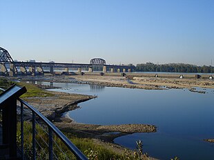 The Ohio River from Jeffersonville Township | |
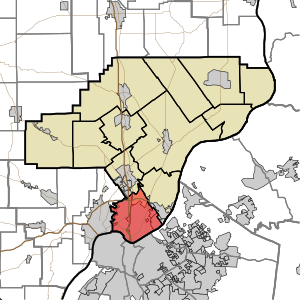 Location of Jeffersonville Township in Clark County | |
| Coordinates: 38°18′57″N 85°44′18″W / 38.31583°N 85.73833°WCoordinates: 38°18′57″N 85°44′18″W / 38.31583°N 85.73833°W | |
| Country | United States |
| State | Indiana |
| County | Clark |
| Government | |
| • Type | Indiana township |
| Area | |
| • Total | 26.88 sq mi (69.6 km2) |
| • Land | 26.57 sq mi (68.8 km2) |
| • Water | 0.31 sq mi (0.8 km2) |
| Elevation | 492 ft (150 m) |
| Population (2010) | |
| • Total | 59,062 |
| • Density | 2,223/sq mi (858/km2) |
| FIPS code | 18-38367[2] |
| GNIS feature ID | 453505 |

Jeffersonville Township is one of twelve townships in Clark County, Indiana. As of the 2010 census, its population was 59,062 and it contained 27,023 housing units.[3]
History[]
Jeffersonville Township was organized in 1817.[4]
Government[]
Jeffersonville Township is governed by the Jeffersonville Township Trustee's office. The current Jeffersonville Trustee is Dale Popp. The Trustee works with a three-person Trustee Advisory Board that consist of Phil Ellis, Brandy Brewer, and Shirley Bell.
Geography[]
According to the 2010 census, the township has a total area of 26.88 square miles (69.6 km2), of which 26.57 square miles (68.8 km2) (or 98.85%) is land and 0.31 square miles (0.80 km2) (or 1.15%) is water.[3] Brick House Pond and Silver Lakes are in this township.
Cities and towns[]
- Clarksville (east three-quarters)
- Jeffersonville (west three-quarters)
- Oak Park (west three-quarters)
Unincorporated towns[]
- Arctic Springs
- Blackiston Village
- Cementville
- Port Fulton
(This list is based on USGS data and may include former settlements.)
Adjacent townships[]
- Silver Creek Township (north)
- Utica Township (northeast)
- New Albany Township, Floyd County (west)
Major highways[]
 Interstate 65
 Interstate 265
 U.S. Route 31
 State Road 3
 State Road 60
 State Road 131
Cemeteries[]
The township contains several cemeteries: Applegate, Civil War, Eastern (aka Chestnut Grove Cemetery), Espy, Gilmore, Grayson, Hale McBride Family, Lacassagne/Moore, McBride, McClintick, Old City, Mulberry Street and Chestnut/Market Street, St. Anthony's, Stewart, and Walnut Ridge.[5]
References[]
- "Jeffersonville Township, Clark County, Indiana". Geographic Names Information System. United States Geological Survey. Retrieved 2009-09-24.
- United States Census Bureau cartographic boundary files
- ^ "US Board on Geographic Names". United States Geological Survey. 2007-10-25. Retrieved 2008-01-31.
- ^ "U.S. Census website". United States Census Bureau. Retrieved 2008-01-31.
- ^ a b "Population, Housing Units, Area, and Density: 2010 - County -- County Subdivision and Place -- 2010 Census Summary File 1". United States Census. Archived from the original on 2020-02-12. Retrieved 2013-05-10.
- ^ Biographical and Historical Souvenir for the Counties of Clark, Crawford, Harrison, Floyd, Jefferson, Jennings, Scott, and Washington, Indiana. Chicago Printing Company. 1889. pp. 8.
- ^ Mauk, Lois. "Clark County, Indiana Cemeteries". usgennet.org. USGenNet. Retrieved 7 September 2014.
External links[]
Municipalities and communities of Clark County, Indiana, United States | ||
|---|---|---|
| Cities | ||
| Towns | ||
| Townships | ||
| CDPs | ||
| Unincorporated communities |
| |
| Footnotes | ‡This populated place also has portions in an adjacent county or counties | |
| ||
- Townships in Clark County, Indiana
- Clarksville, Indiana
- Jeffersonville, Indiana
- Townships in Indiana