Jericho Governorate
Jericho Governorate | |
|---|---|
 2018 United Nations map of the area, showing the Israeli occupation arrangements in the governorate | |
 | |
| Coordinates: 32°01′29.72″N 35°26′43.73″E / 32.0249222°N 35.4454806°ECoordinates: 32°01′29.72″N 35°26′43.73″E / 32.0249222°N 35.4454806°E | |
| Country | |
| Population (2017)[1] | |
| • Total | 50,002 |
| This figure excludes the Israeli West Bank Settlements | |

| Governorates of the West Bank (State of Palestine) |
|---|

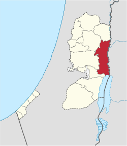
The Jericho Governorate (Arabic: محافظة أريحا, romanized: Muḥāfaẓat Arīḥā) is one of 16 Governorates of Palestine. It is located along the eastern areas of the West Bank, along the northern Dead Sea and southern Jordan River valley bordering Jordan. The governorate spans west to the mountains east of Ramallah and the eastern slopes of Jerusalem, including the northern reaches of the Judaean Desert. The population of the Jericho Governorate is estimated to be 50,002, including 13,334 Palestinian refugees in the governorate's camps.[1]
Agriculture is important to the economy in the district, especially in the valley near Jericho, its capital. Jericho is often considered the oldest continuous settlement in the world; its many historic and archaeological sites attract numerous tourists to the area.
Elishia's Park (also called Elisee's Spring and Ein el-Sultan) is an oasis in the Jericho District that is home to orchards, palm groves, banana plantations, and other flora.[2]
Localities[]
Cities[]
Municipalities[]
Villages[]
Refugee camps[]
References[]
- ^ a b "Main Indicators by Type of Locality - Population, Housing and Establishments Census 2017" (PDF). Palestinian Central Bureau of Statistics (PCBS). Retrieved 2021-01-19.
- ^ "Laureates 1999". World Heritage Centre.
| Cities |  | |
|---|---|---|
| Municipalities | ||
| Villages | ||
| Refugee camps | ||
| Other | ||
Governorates of the Palestinian Authority | ||
|---|---|---|
| West Bank | ||
| Gaza Strip | ||
- Palestinian National Authority governorate templates
- Jericho Governorate
- Governorates of the Palestinian National Authority in the West Bank