Joinville Island group
This article does not cite any sources. (January 2013) |
Nickname: PeePee Islands | |
|---|---|
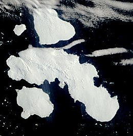 Satellite picture of the group | |
 Joinville Island group:
| |
| Geography | |
| Location | Antarctica |
| Coordinates | 63°15′S 55°45′W / 63.250°S 55.750°WCoordinates: 63°15′S 55°45′W / 63.250°S 55.750°W |
| Archipelago | Joinville Island group |
| Administration | |
| Administered under the Antarctic Treaty System | |
| Demographics | |
| Population | Uninhabited |
Joinville Island group is a group of antarctic islands, lying off the northeastern tip of the Antarctic Peninsula, from which Joinville Island group is separated by the Antarctic Sound. Joinville Island, located at 63°15′S 55°45′W / 63.250°S 55.750°W, is the largest island of the Joinville Island group. Immediately north of Joinville Island and separated by Larsen Channel lies D'Urville Island, Antarctica, the northernmost island of the Joinville Island group, being located at 63°05′S 56°20′W / 63.083°S 56.333°W.
The Joinville Island group was discovered in 1838 by a French expedition under Captain Jules Dumont d'Urville.
See also[]
- Composite Antarctic Gazetteer
- List of Antarctic and sub-Antarctic islands
- List of Antarctic islands south of 60° S
- SCAR
- Territorial claims in Antarctica
References[]
This Joinville Island group location article is a stub. You can help Wikipedia by . |
Categories:
- Joinville Island group
- Islands of Graham Land
- Joinville Island group geography stubs