Jubilee Parkway
Jubilee Parkway | |
|---|---|
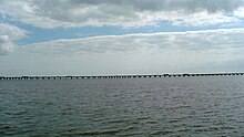 An eastern portion of the Jubilee Parkway as seen from Meaher State Park. | |
| Coordinates | 30°39′55″N 87°57′49″W / 30.6652°N 87.9637°W |
| Carries | 4 lanes of |
| Crosses | Mobile Bay |
| Locale | Baldwin County / Mobile, Alabama, USA |
| Characteristics | |
| Design | Girder bridge |
| Total length | 7.5 miles (12.1 km) |
| History | |
| Opened | 1978 |
| Location | |
 | |

The Jubilee Parkway is a pair of parallel concrete viaduct bridges that carry Interstate 10 across Mobile Bay from the George Wallace Tunnel on Blakeley Island in Mobile, Alabama eastbound to Spanish Fort/Daphne, Alabama. The bridges are similar in design to the pre-Hurricane Katrina I-10 Twin Span Bridge near New Orleans, Louisiana. Each of the two bridges is two lanes wide, for a total of four lanes, and 7.5 miles (12.1 km) long. The parkway was completed in 1978[1] and crosses the northern portion of Mobile Bay, running roughly parallel to the nearby Battleship Parkway,[2] with which it has an interchange. It was named for the jubilee phenomenon that occurs intermittently in Mobile Bay, but is commonly referred to locally and in the media as the "Bayway".[3]
Expansion[]

Since 2001, the Alabama Department of Transportation (ALDOT) has planned to expand the parkway to a total of eight lanes in addition to a connecting cable-stayed bridge with a main span 1,250 feet (381 m) long and 190 feet (58 m) high that would bypass the George Wallace Tunnel. This is intended to eliminate the current traffic bottleneck on I-10 at the tunnel,[2] but is very controversial locally due to the proposed bridge's potential visual and economic impact on the city. The arguments against the bridge have focused on the bridge's height of roughly 500 feet (152 m), taller than any other structure in the city except for the RSA Battle House Tower, as potentially overshadowing the city. The potential economic impact is that, with less than 190 feet (58 m) of clearance under the bridge, it would hamper large ships and projects from the Port of Mobile and prevent large cruise ships from accessing the Alabama Cruise Terminal.[4]
Incidents[]
One of the largest multi-vehicle collisions in U.S. history took place on the Parkway on the morning of March 20, 1995. Caused by fog on Mobile Bay, the accident involved around 200 vehicles, killed one person, and injured more than 90 others.[5]
During the ice storm of January 28–30, 2014, the Bayway was closed several times for hours, diverting traffic onto the Causeway, while ALDOT crews used grading equipment to remove ice from the roadway. Asked why the Bayway wasn't sanded or salted, ALDOT officials said that they did not have the spreader equipment since ice storms occur in the area only about once every 20 years.[6]
References[]
| Wikimedia Commons has media related to Jubilee Parkway. |
- ^ "History". "Rivers of Alabama: Mobile Bay". Archived from the original on March 12, 2008. Retrieved December 28, 2007.
- ^ a b "Mobile". "Mobile @ SouthEastRoads". Archived from the original on January 8, 2008. Retrieved December 28, 2007.
- ^ "Interstate 10 Eastbound". "Alabama: SouthEastRoads". Retrieved December 28, 2007.
- ^ "Bridging the divide or the snarl ahead?". "Mobile Bay Times". Retrieved December 28, 2007.
- ^ "Performance of Satellite Fog Detection Techniques" (PDF). "National Weather Association". Archived from the original (PDF) on November 20, 2008. Retrieved December 28, 2007.
- ^ "WKRG".
- Bridges in Mobile, Alabama
- Bridges completed in 1978
- Mobile Bay
- Interstate 10
- Road bridges in Alabama
- Bridges on the Interstate Highway System
- Concrete bridges in the United States
- Girder bridges in the United States