Jurong East
Jurong East | |
|---|---|
| Other transcription(s) | |
| • Chinese | 裕廊东 (Simplified) 裕廊東 (Traditional) Yùlángdōng (Pinyin) Jū-lông-tang (Hokkien POJ) |
| • Malay | Jurong Timur (Rumi) جوروڠ تيمور (Jawi) |
| • Tamil | ஜூரோங் கிழக்கு Jūrōṅ Kiḻakku (Transliteration) |
   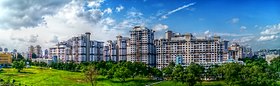   From top left to right: Chinese Garden, Jurong Regional Library, Jurong Town Hall, HDB flats along Jurong East, Singapore Science Centre, Jurong East MRT station | |
 Jurong East Location of Jurong East within Singapore | |
| Coordinates: 1°19′43.98″N 103°44′23.81″E / 1.3288833°N 103.7399472°E | |
| Country | |
| Region | West Region
|
| CDC | |
| Town councils |
|
| Constituencies | |
| Government | |
| • Mayor | South West CDC
|
| • Members of Parliament | Jurong GRC
West Coast GRC Yuhua SMC
|
| Area | |
| • Total | 17.83 km2 (6.88 sq mi) |
| • Residential | 1.65 km2 (0.64 sq mi) |
| Population | |
| • Total | 78,600 |
| • Density | 4,400/km2 (11,000/sq mi) |
| Demonym(s) | Official
|
| Postal district | 22 |
| Dwelling units | 23,379 |
| Projected ultimate | 30,000 |

Jurong East is a planning area and residential town located in the West Region of Singapore. It borders Jurong West and Boon Lay to the west, Clementi to the east, Tengah and Bukit Batok to the north and Selat Jurong to the south.
History[]
The development of Jurong started in the 1970s when estates such as Boon Lay, Taman Jurong, Bukit Batok, Bukit Gombak, Hong Kah, Teban Gardens and Yuhua were built, mostly due to the resettlement of Hong Kah (present-day Tengah) and surrounding villages. Yuhua, Teban Gardens, Bukit Batok and Bukit Gombak formed Jurong East.
Subzones[]
There are 10 subzones in Jurong East.[4]
- Jurong Port
- Penjuru Crescent
- Jurong River
- Teban Gardens
- Lakeside
- Jurong Gateway
- International Business Park
- Toh Guan
- Yuhua East
- Yuhua West
Politics[]
The Northern section is under Jurong GRC and Southern section under West Coast GRC.
Education[]
There are 3 Primary schools and 4 Secondary schools in Jurong East.
- Commonwealth Secondary School
- Crest Secondary School
- Fuhua Primary School (which Pandan Primary School merged into)
- Jurong Primary School
- Jurongville Secondary School
- Shuqun Secondary School
- Yuhua Primary School
Recreation[]
Sports[]
- Jurong East Sports and Recreation Centre
Leisure[]
- Jurong Lake Park
- Pandan Gardens Park Connector
- Jurong Park Connector
- Toh Guan Neighbourhood Park
- Pandan Gardens Leisure Park
- Pandan Reservoir Fitness Corner
- Jurong Country Club
- Hong Kah East Neighbourhood Park
- Yuhua Village Neighbourhood Park
- Genting Hotel Jurong
Tourist attractions[]
There are 3 tourist attractions in Jurong East:
- Science Centre
- Snow City
- Chinese Garden
Transport[]
Roads[]
Jurong East is connected to the rest of Singapore with the Pan Island Expressway (PIE) and the Ayer Rajah Expressway (AYE).
- Jurong Town Hall Road interconnects the two expressways with Boon Lay, Yuhua, Jurong Regional Centre, International Business Park, Jurong Lake and Teban Gardens.
- Toh Guan is connected to the PIE via Toh Guan Road, while Jurong Canal Road provides an alternative at Boon Lay for traffic to (Tuas) and from (Changi) the PIE.
- From the AYE, arterial roads Jurong Pier Road, Jurong Port Road and Penjuru Road (along with Minor Arterial road Teban Gardens Crescent) carry the traffic to Jurong River, Penjuru Crescent and Jurong Port.
- Boon Lay Way and Jalan Buroh are the two other arterial roads in Jurong East, which provides inter-connectivity across the various subzones in the area.
Public transport[]
Mass Rapid Transit[]
Jurong East is served by 2 MRT stations – Jurong East and Chinese Garden.
Bus[]
Jurong East Bus Interchange started operations in 1985. It later moved to its first temporary site on 17 December 2011.[5] All the bus services, except 51, 52, 105, 160, 197 & 506 were handed over to Tower Transit Singapore on 12 June 2016.[6][7]
The former temporary interchange will move to another site on 6 December 2020, to make way for the construction of the Jurong Region Line and new transport hub by 2027. All bus services with the exception of service 78, 79, CW3 and CW4 will move there.[8]
Economy[]
At Jurong Port, Jurong River, Penjuru Crescent, and parts of Toh Guan and Teban Gardens, there is land allocated for business activities.
Jurong Lake District[]
Consisting of Jurong Lake, Jurong Gateway, International Business Park and the southern section of Toh Guan, the Jurong Lake District is a prime regional centre serving as an commercial hub for business developments remote from the Central Area, to meet the various demands of businesses and provide employment opportunities closer to people staying in the West Region of Singapore.
International Business Park[]
Commercial[]
Shopping malls[]


Within the boundaries of Jurong Gateway and Toh Guan, there are 4 shopping malls,
Town Centre[]
The Town Centre of Jurong East is located at Jurong Regional Centre, presently known as Jurong Gateway subzone.[9]
- Jurong East Town Centre
- Jurong Regional Library

References[]
- ^ Jump up to: a b City Population – statistics, maps and charts | Jurong West
- ^ Jump up to: a b HDB Key Statistics FY 2014/2015 Archived 4 March 2016 at the Wayback Machine
- ^ "Statistics Singapore - Geographic Distribution - 2018 Latest Data". Retrieved 11 February 2019.
- ^ Singapore Department of Statistics – Planning Areas/Subzones in Singapore (Year 2015) Archived 8 April 2015 at the Wayback Machine
- ^ "Bus Services Operating From The New Jurong East Temporary Bus Interchange". SBS Transit. Retrieved 9 February 2017.
- ^ "Transition to a Government Contracting Model For the Public Bus Industry". Land Transport Authority. 21 May 2014. Retrieved 9 February 2016.
- ^ "LTA awards first tendered bus package to Tower Transit Group Limited". Land Transport Authority. 8 May 2015. Retrieved 9 February 2016.
- ^ "Relocation of Jurong East Bus Interchange from 6 December 2020". Land Transport Authority.
- ^ "The Jurong Story: From Jurong to Jurong Gateway". The Straits Times.
| Wikimedia Commons has media related to Jurong East. |
| show Authority control |
|---|
- Jurong East
- Places in Singapore
- West Region, Singapore
- New towns in Singapore
- New towns started in the 1970s