Könkämäeno
This article may be expanded with text translated from the corresponding article in Finnish. (December 2009) Click [show] for important translation instructions.
|
| Könkämäeno Könkämäälven | |
|---|---|
 | |
| Location | |
| Countries | |
| Physical characteristics | |
| Source | Lake Kilpisjärvi |
| • coordinates | 68°56′17″N 20°51′01″E / 68.93806°N 20.85028°E |
| • elevation | 473 m (1,552 ft) |
| Mouth | Muonio River |
• coordinates | 68°29′04″N 22°17′45″E / 68.48444°N 22.29583°ECoordinates: 68°29′04″N 22°17′45″E / 68.48444°N 22.29583°E |
• elevation | 329 m (1,079 ft) |
| Length | 150 km (93 mi)[1] |

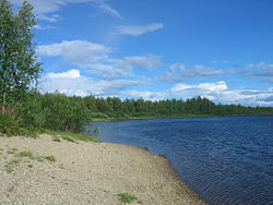
Könkämäeno (Swedish: Könkämäälven) is a river in Finland and Sweden in Finnish and Swedish Lapland. It forms the upper course of the Muonionjoki river, which begins where the Könkämäeno river meets the Lätäseno river. The river begins from Lake Kilpisjärvi and forms together with Muonionjoki and the lower course of Torne River the border between Sweden and Finland.
See also[]
- List of rivers in Finland
References[]
- ^ "Könkämäälven". Nationalencyklopedin (in Swedish). Retrieved 14 July 2010. (subscription required)
This Lapland (Finland) location article is a stub. You can help Wikipedia by . |
Categories:
- Rivers of Norrbotten County
- Torne river basin
- Rivers of Enontekiö
- Rivers of Finland
- Finland–Sweden border
- International rivers of Europe
- Border rivers
- Lapland (Finland) geography stubs
- Europe river stubs
- Finland geography stubs
- Sweden river stubs