Kūaotunu
Kūaotunu | |
|---|---|
 Kūaotunu | |
| Coordinates: 36°43′19″S 175°43′49″E / 36.722062°S 175.730175°ECoordinates: 36°43′19″S 175°43′49″E / 36.722062°S 175.730175°E | |
| Country | New Zealand |
| Region | Waikato |
| District | Thames-Coromandel District |
| Population (2001)[1] | |
| • Total | 345 in Rings Beach Kuaotunu und West-Kuaotunu |
| Postcode(s) | 3592 |

Kūaotunu is a small coastal township at the east coast of the Coromandel Peninsula on the mouth of the Kuaotunu River on the North Island of New Zealand.
Name[]
The name of the settlement is of Māori origin, meaning ‘to inspire fear in young animals’ or ‘roasted young’, probably relating to the good hunting and fishing grounds in the area.[2] In 2019, the name of the locality was officially gazetted as Kūaotunu.[3]
Tourism[]
Kūaotunu is a popular destination for summer holidays for tourists on the Coromandel tourist circuit. It is one of the most northern beaches on the east coast of the Coromandel Peninsula and is popular with campers, surfers and beach lovers.
Mining[]

The local mines and their stamping batteries, which were installed in the late 19th century, had hopeful names: Try Fluke, Carbine, Mariposa, John Bull, Great Mercury, Red Mercury, Irene, Waiawa, Otama and Kapai-Vermont.[2]
The Try Fluke Mine was a substantial gold mine close to Kūaotunu.[4] Its name goes back to its discovery in 1889, when prospectors asked the Maori Charles Kawhine, known locally as Coffin, what he was doing, and he replied: "Oh, try fluke." At least this was understood instead of "Tryin’ luck", and the name stuck to the mine, which was established there.


The mine consisted of several vertical shafts and horizontal tunnels, also known as adits or drives, down the hill side. It is still possible to explore some of these drives. One of them runs 50 m into the mountain, ending at a filled-in shaft. In front of the mine is a flat strip of ground, where mining railway used to run.[4] More than 2760 ounces of gold have been extracted by January 1893, after implementing the Cassel cyanide process,[5] by which the level of gold recoverable was increased from 55% to 95%.[6] Official production data by the Thames Mines show a yield of 2,327,619 oz bullion with a value of NZ$845 mio.[2]
Logging[]
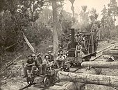
Logging played only a secondary role in the area, but mines needed Kauri timber both for construction and for heating the ore ovens. Local loggers thus operated a narrow gauge logging railway including a small steam engine.[2]
The locomotive with a gauge of probably 2 ft 6 in (762 mm) had been imported from Manning, Wardle & Co in Hunslet, England with works number 859 from 1883. As the 6 kilometres (3.7 mi) long line was flat and had no or little sidings, the empty log bogies were normally pushed out into the bush and pulled back after loading them with logs. This procedure reduced the risk of derailments of the loaded bogies, because pulling caused less derailments than pushing.[7]
The Kūaotunu bush contained approximately 6 mio super feet of timber. E.H. Irving worked it from 1907 to 1909 as a contractor to the Kauri Timber Company (KTC). He and his bushmen felled and transported the logs to the Whangapoua Harbour estuary, where they were dumped, made up into rafts, and towed by powerful steamer to a KTC sawmill.[7]
Church[]
A church, St Columcille's, was built in 1893, when the town had approximately 2,000 inhabitants. The church cost 100 pounds to build, and was inaugurated free of debt. The material for the Roman Catholic Church at Kūaotunu arrived in January 1893 by ship, and was carted from the beach to the site near to the public school is. The building was disassembled in 1954 and re-erected at Tairua.[8]
External links[]
| Wikivoyage has a travel guide for Kūaotunu. |
References[]
- ^ Kuaotunu Community Plan. December 2009. Retrieved on 7 August 2018.
- ^ Jump up to: a b c d Carol Wright: Kuaotunu – Boom! Bustle! Bust! with excerpts from 'This is Kuaotunu' by R. A. (Alf) Simpson. Pages 16–20.
- ^ "Place name detail: Kūaotunu". New Zealand Gazetteer. New Zealand Geographic Board. Retrieved 2 August 2019.
- ^ Jump up to: a b Try Fluke Gold Mine (Coromandel). Retrieved on 3 August 2018.
- ^ The Cassel Process at Kuaotunu. New Zealand Herald, Volume XXX, Issue 9110, 30 January 1893, page 5.
- ^ Grace's Guide: Cassel Cyanide Co.
- ^ Jump up to: a b Paul Mahoney: The era of the bush tram in New Zealand. IPL Books, Wellington, New Zealand, 1998. ISBN 0908876807.
- ^ The old days.
- Thames-Coromandel District
- Populated places in Waikato
- Mining railways in New Zealand
- Logging railways in New Zealand