Kairouan
Kairouan
ٱلْقَيْرَوَان | |
|---|---|
 | |
 Kairouan Location in Tunisia | |
| Coordinates: 35°40′38″N 10°06′03″E / 35.67722°N 10.10083°ECoordinates: 35°40′38″N 10°06′03″E / 35.67722°N 10.10083°E | |
| Country | Tunisia |
| Governorate | Kairouan |
| Founded | 670 CE |
| Founded by | Uqba ibn Nafi |
| Elevation | 68 m (223 ft) |
| Population (2014) | |
| • Total | 187,000 |
| Website | Official website |
UNESCO World Heritage Site | |
| Criteria | Cultural: i, ii, iii, v, vi |
| Reference | 499 |
| Inscription | 1988 (12th Session) |
| Area | 68.02 ha |
| Buffer zone | 154.36 ha |


Kairouan (Arabic: ٱلْقَيْرَوَان ![]() listen), also spelled Al Qayrawān or Kairwan (
listen), also spelled Al Qayrawān or Kairwan (![]() Qeirwān), is the capital of the Kairouan Governorate in Tunisia. It is a UNESCO World Heritage site. The city was founded by the Umayyads around 670.[1] In the period of Caliph Mu'awiya (reigned 661–680), it became an important centre for Sunni Islamic scholarship and Quranic learning,[2] and thus attracting many Muslims from various parts of the world, next only to Mecca and Medina and Jerusalem . The holy Mosque of Uqba is situated in the city.[3][4]
Qeirwān), is the capital of the Kairouan Governorate in Tunisia. It is a UNESCO World Heritage site. The city was founded by the Umayyads around 670.[1] In the period of Caliph Mu'awiya (reigned 661–680), it became an important centre for Sunni Islamic scholarship and Quranic learning,[2] and thus attracting many Muslims from various parts of the world, next only to Mecca and Medina and Jerusalem . The holy Mosque of Uqba is situated in the city.[3][4]
In 2014, the city had about 187,000 inhabitants.
Etymology[]
The name (ٱلْقَيْرَوَان Al-Qayrawân) is an Arabic word meaning "military group" or "caravan",[5][6] borrowed early on from the Middle Persian word kārawān[7] (modern Persian کاروان kârvân), meaning "military column" (kâr people/military + vân outpost) or "caravan" (see caravanserai).[8][9][10] In Berber, the city used to be called Tikirwan تيكيروان,[11] thought to be an adaptation of the Arabic name.
Geography[]
Kairouan, the capital of Kairouan Governorate, lies south of Sousse, 50 km (31 mi) from the east coast, 75 km (47 mi) from Monastir and 184 km (114 mi) from Tunis.
Cityscape[]

History[]

The foundation of Kairouan dates to about the year 670 when the Arab general Uqba ibn Nafi of Caliph Mu'awiya selected a site in the middle of a dense forest, then infested with wild beasts and reptiles, as the location of a military post for the conquest of the West.[citation needed] Formerly, the city of Kamounia was located where Kairouan now stands. It had housed a Byzantine garrison before the Arab conquest, and stood far from the sea – safe from the continued attacks of the Berbers who had fiercely resisted the Arab invasion. Berber resistance continued, led first by Kusaila, whose troops killed Uqba at Biskra about fifteen years after the establishment of the military post,[12] and then by a Berber woman called Al-Kahina who was killed and her army defeated in 702. Subsequently, there occurred a mass conversion of the Berbers to Islam. Kharijites or Islamic "outsiders" who formed an egalitarian and puritanical sect appeared and are still present on the island of Djerba.
In October, 741, in the course of the Great Berber Revolt in the Maghreb, the Ifriqiyan army, along with a Syrian force dispatched by the caliph, was destroyed by the Berbers at the Battle of Bagdoura. The governor Kulthum ibn Iyad al-Qasi perished in the field, his nephew and successor Balj ibn Bishr al-Qushayri was holed up with the remnant of the army in Spain, leaving the whole of Ifriqiya open to the advance of the Berber rebels. Not having any more forces at his disposal, the Umayyad Caliph Hisham quickly appointed Handhala ibn Safwan as governor of Ifriqiya, with supervisory authority over all the Maghreb (North Africa west of Egypt) and al-Andalus (Spain), and instructed him to take whatever forces he could gather to defend Ifriqiya and quash the Berber rebellion. Leaving Egypt in the hand of Hafs ibn al-Walid ibn Yusuf al-Hadrami, Handhala set out westwards in February 742, picking up additional forces from Barqa (Cyrenaica) and Tripoli (Tripolitana). He arrived in Kairouan around April, 742. The qadi of Ifriqiya, , had been managing the defense of Kairouan, and succeeded in fending off an attack by the Berber rebel army raised in southern Tunisia by the Sufrite leader . Handhala ibn Safwan arrived in Kairouan just as Oqasha was said to be mounting a new attack, in coordination with another large Berber army coming in from the west, led by . The Berber rebel armies were to make junction in front of Kairouan, before launching their final attack on the city. Wasting no time, Handhala dispatched a cavalry force to slow down Abd al-Wahid's progress, and threw the bulk of his forces south, defeating Oqasha in a bloody battle at and taking him prisoner. But Handhala had taken a lot of losses himself, and now faced the unhappy prospect of Abd al-Wahid's gigantic army, said to be some 300,000, ostensibly the largest Berber army ever seen. Hurrying back, Handhala is said to have put the entire population of Kairouan under arms to bolster his ranks, before setting out again. In perhaps the bloodiest encounter in the Berber wars, Handhala ibn Safwan defeated the great Berber army of Abd al-Wahid ibn Yazid at in May 742 (perhaps a little later), just three miles outside of Kairouan. Some 120,000-180,000 Berbers, including Abd al-Wahid, fell in the field of battle in that single encounter.[13]
In 745, Kharijite Berbers captured Kairouan, which was already at that time a developed city with luxuriant gardens and olive groves. Power struggles continued until Ibrahim ibn al-Aghlab recaptured Kairouan at the end of the 8th century.
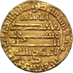
In 800 Caliph Harun ar-Rashid in Baghdad confirmed Ibrahim as Emir and hereditary ruler of Ifriqiya. Ibrahim ibn al-Aghlab founded the Aghlabid dynasty which ruled Ifriqiya between 800 and 909. The new Emirs embellished Kairouan and made it their capital. It soon became famous for its wealth and prosperity, reaching the levels of Basra and Kufa and giving Tunisia one of its golden ages long sought[by whom?] after the glorious days of Carthage.
The Aghlabites built the great mosque and established in it a university that was a centre of education both in Islamic thought and in the secular sciences. Its role can be compared to that of the University of Paris in the Middle Ages. In the 9th century, the city became a brilliant focus of Arab and Islamic cultures attracting scholars from all over the Islamic World. In that period Imam Sahnun and Asad ibn al-Furat made of Kairouan a temple of knowledge and a magnificent centre of diffusion of Islamic sciences. The Aghlabids also built palaces, fortifications and fine waterworks of which only the pools remain. From Kairouan envoys from Charlemagne and the Holy Roman Empire returned with glowing reports of the Aghlabites palaces, libraries and gardens – and from the crippling taxation imposed to pay for their drunkenness and sundry debaucheries. The Aghlabite also pacified the country and conquered Sicily in 827.[14]

In 893, through the mission of Abdullah al Mahdi, the Kutama Berbers from the west of the country started the movement of the Shiite Fatimids. The year 909 saw the overthrow of the Sunni Aghlabites who ruled Ifriqiya and the establishment of the Fatimid dynasty. During the rule of the Fatimids, Kairouan was neglected and lost its importance: the new rulers resided first in Raqqada but soon moved their capital to the newly built Al Mahdiyah on the coast of modern Tunisia. After succeeding in extending their rule over all of central Maghreb, an area consisting of the modern countries of Morocco, Algeria, Tunisia and Libya, they eventually moved east to Egypt to found Cairo making it the capital of their vast Caliphate and leaving the Zirids as their vassals in Ifriqiya. Governing again from Kairouan, the Zirids led the country through another artistic, commercial and agricultural heyday. Schools and universities flourished, overseas trade in local manufactures and farm produce ran high and the courts of the Zirids rulers were centres of refinement that eclipsed those of their European contemporaries. When the Zirids declared their independence from Cairo and their conversion to Sunni Islam in 1045 by giving allegiance to Baghdad, the Fatimid Caliph Ma'ad al-Mustansir Billah sent as punishment hordes of troublesome Arab tribes (Banu Hilal and Banu Sulaym) to invade Ifriqiya. These invaders so utterly destroyed Kairouan in 1057 that it never regained its former importance and their influx was a major factor in the spread of nomadism in areas where agriculture had previously been dominant. Some 1,700 years of intermittent but continual progress was undone within a decade as in most part of the country the land was laid to waste for nearly two centuries. In the 13th century under the prosperous Hafsids dynasty that ruled Ifriqiya, the city started to emerge from its ruins. It is only under the Husainid Dynasty that Kairouan started to find an honorable place in the country and throughout the Islamic world. In 1881, Kairouan was taken by the French, after which non-Muslims were allowed access to the city. The French built the 600 mm (1 ft 11+5⁄8 in) Sousse–Kairouan Decauville railway, which operated from 1882 to 1996, before it was regauged to 1,000 mm (3 ft 3+3⁄8 in) gauge.[citation needed]
Climate[]
Kairouan has a hot semi-arid climate (Köppen climate classification BSh).
| hideClimate data for Kairouan (1981-2010, extremes 1901-2017) | |||||||||||||
|---|---|---|---|---|---|---|---|---|---|---|---|---|---|
| Month | Jan | Feb | Mar | Apr | May | Jun | Jul | Aug | Sep | Oct | Nov | Dec | Year |
| Record high °C (°F) | 30.0 (86.0) |
37.3 (99.1) |
39.2 (102.6) |
37.8 (100.0) |
44.6 (112.3) |
48.0 (118.4) |
47.9 (118.2) |
50.3 (122.5) |
45.0 (113.0) |
41.3 (106.3) |
36.0 (96.8) |
30.9 (87.6) |
50.3 (122.5) |
| Average high °C (°F) | 17.2 (63.0) |
18.4 (65.1) |
21.1 (70.0) |
24.3 (75.7) |
29.2 (84.6) |
34.3 (93.7) |
37.7 (99.9) |
37.5 (99.5) |
32.5 (90.5) |
27.8 (82.0) |
22.2 (72.0) |
18.3 (64.9) |
26.7 (80.1) |
| Daily mean °C (°F) | 11.5 (52.7) |
12.4 (54.3) |
14.8 (58.6) |
17.5 (63.5) |
21.8 (71.2) |
26.2 (79.2) |
29.3 (84.7) |
29.5 (85.1) |
25.7 (78.3) |
21.7 (71.1) |
16.5 (61.7) |
12.9 (55.2) |
20.0 (68.0) |
| Average low °C (°F) | 6.9 (44.4) |
7.3 (45.1) |
9.3 (48.7) |
11.7 (53.1) |
15.4 (59.7) |
19.3 (66.7) |
22.2 (72.0) |
22.9 (73.2) |
20.4 (68.7) |
16.7 (62.1) |
11.7 (53.1) |
8.2 (46.8) |
14.3 (57.8) |
| Record low °C (°F) | −4.5 (23.9) |
−3.0 (26.6) |
−3.0 (26.6) |
0.0 (32.0) |
4.0 (39.2) |
6.5 (43.7) |
8.0 (46.4) |
12.0 (53.6) |
9.0 (48.2) |
5.5 (41.9) |
−3.0 (26.6) |
−3.5 (25.7) |
−4.5 (23.9) |
| Average precipitation mm (inches) | 28.7 (1.13) |
19.1 (0.75) |
28.1 (1.11) |
26.6 (1.05) |
22.8 (0.90) |
8.0 (0.31) |
2.0 (0.08) |
11.4 (0.45) |
44.2 (1.74) |
41.6 (1.64) |
28.3 (1.11) |
29.0 (1.14) |
289.8 (11.41) |
| Average precipitation days (≥ 1.0 mm) | 3.5 | 3.7 | 4.9 | 4.3 | 2.9 | 1.6 | 0.7 | 2.1 | 3.5 | 4.3 | 2.9 | 3.5 | 37.9 |
| Average relative humidity (%) | 64 | 62 | 62 | 61 | 58 | 53 | 49 | 53 | 59 | 65 | 65 | 65 | 60 |
| Mean monthly sunshine hours | 186.0 | 190.4 | 226.3 | 252.0 | 300.7 | 324.0 | 362.7 | 334.8 | 270.0 | 235.6 | 207.0 | 186.0 | 3,075.5 |
| Mean daily sunshine hours | 6.0 | 6.8 | 7.3 | 8.4 | 9.7 | 10.8 | 11.7 | 10.8 | 9.0 | 7.6 | 6.9 | 6.0 | 8.4 |
| Source 1: Institut National de la Météorologie (precipitation days/humidity/sun 1961–1990, extremes 1951–2017)[15][16][17][note 1] | |||||||||||||
| Source 2: NOAA (humidity and sun 1961–1990),[19] Deutscher Wetterdienst (extremes, 1901–1990)[20] | |||||||||||||
Religion[]

Between the 9th and 11th centuries AD, Kairouan functioned as one of the great centers of Islamic civilization and gained a reputation as a hotbed of scholarship across the entire Maghreb. During this period, the Great Mosque of Kairouan became both a place of prayer and a center for teaching Islamic sciences under the Maliki current.[21] A unique religious tradition practiced in Kairouan was the use of Islamic law to enforce monogamy by stipulating it in the marriage contract.[22] Local tradition holds that seven pilgrimages to the Great Mosque equals one pilgrimage to Mecca,[23][24] which according to some, made Kairouan the fourth holiest city in Islam after Mecca, Medina and Jerusalem.[25] As of 2004, the city contained 89 mosques.[26] Sufi festivals are held in the city in memory of saints.[27]
Before the arrival of the French in 1881, non-Muslims were forbidden from living in Kairouan.[28] A Christian community had existed during the early 11th century[29] alongside Jews who were among the original settlers of Kairouan. The Jewish community's golden era began in the late 8th century and lasted until the early 11th century during which time it played an important role in Jewish history, having been a world center of Talmudic and Halakhic scholarship for at least three generations.[30] The Banu Hilal conquest of Kairouan in 1057 led to the decline of the medieval community with Jews only returning after Tunisia was established as a French protectorate in 1881. By the 1960s the community had disappeared,[31] and all that remains is their dilapidated cemetery.
Main sights[]
Great Mosque of Sidi-Uqba[]
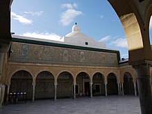
The city's main landmark is the Great Mosque of Sidi-Uqba (also known as the Great Mosque of Kairouan) which is one of the most impressive and largest Islamic monuments in North Africa. Originally built when Kairouan was founded in 670 AD, the mosque currently occupies an area of over 9,000 square metres (97,000 sq ft) and is one of the oldest places of worship in the Islamic world. The mosque became a center of education both in Islamic thought and in the secular sciences and helped the city to develop and expand.

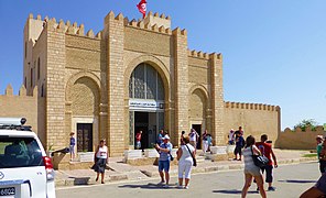
Mosque of the Three Gates[]
The Mosque of the Three Gates was founded in 866. Its façade is a notable example of Islamic architecture.[32] It has three arched doorways surmounted by three inscriptions in Kufic script, interspersed with floral and geometrical reliefs and topped by a carved frieze; the first inscription includes the verses 70–71 in the sura 33 of Quran.[33] The small minaret was added during the restoration works held under the Hafsid dynasty. The prayer hall has a nave and two aisles, divided by arched columns, parallel to the qibla wall.
Mosque of the Barber[]
The Mausoleum of Sidi Sahab, generally known as the Mosque of the Barber, is actually a zaouia located inside the city walls. It was built by the Muradid Hammuda Pasha Bey (mausoleum, dome and court) and Murad II Bey (minaret and madrasa). In its present state, the monument dates from the 17th century.[34]
The mosque is a veneration place for Abu Zama' al-Balaui, a companion of the prophet Muhammad, who, according to a legend, had saved for himself three hairs of Muhammad's beard, hence the edifice's name.[35] The sepulchre place is accessed from a cloister-like court with richly decorated ceramics and stuccoes.
Aghlabid basins[]
The Aghlabid basins (les bassins des Aghlabides) are a Tunisian historical monument located in Kairouan.
Dating from the beginning of IX Century and located outside the ramparts of the medina of Kairouan, they are considered to be the most important hydraulic systems in the history of the Muslim world.[36]
The structure covers an area of 11000 square meters and consists of a small settling basin, a large basin for storing water and two drawing tanks, all having a total storage capacity of 68800 cubic meters.[37]

Economy[]
The primary economic sectors in Kairouan are industry, agriculture and tourism.
Industry[]
The Kairouan region currently has 167 industrial companies offering more than 10,000 jobs, of which 33 are fully exporters. The industrial activities of the region are quite diversified, although the agrifood industry sector is preeminent with 91 units. [38]
Agriculture[]
The governorate of Kairouan is known mainly for the production of vegetables (peppers, tomatoes) and fruits (apricots, almonds and olives). It is the leading national producer of chili peppers with nearly 90,000 tonnes in 2019, as well as apricots with more than 15,000 tonnes. [39]
Tourism[]

Kairouan is one of the four most visited sites in Tunisia along with Carthage, El Jem and Le Bardo as historic sites. Tourist activity is essentially, if not almost exclusively, a cultural activity focused on the sites and monuments of the city of Kairouan. The tourist assets and potential of the governorate of Kairouan derive mainly from the following three families of factors: - People, with their own cultures (lifestyles) and with their achievements, - Nature endowed with beautiful and varied natural sites, rich flora and fauna in certain regions, certain sources of thermal and mineral water, an often little rainy and mild climate, - The history (including the present) of the governorate, which has given it a heritage, especially archaeological, of great value. [40]
Notable people[]
Food[]

Kairouan is known for its pastries (e.g. zlebia and makroudh).
In popular culture[]
Kairouan was used as a filming location for the 1981 film Raiders of the Lost Ark, standing in for Cairo.[42] As the film is set in 1936, television antennas throughout the city were taken down for the duration of filming.[43]
Twin towns[]
|
|
Gallery[]

Trois Portes Mosque

Great Mosque in night

Remparts en flame
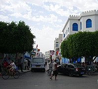
Kairouan Center-Ville

Souk of Kairouan

Tunisia Hotel
Piscines des Aghlabides

Salat of Tarawih in Great Mosque


See also[]
- Kairouan's significance in Islam
References[]
- ^ Nagendra Kr Singh, International encyclopaedia of Islamic dynasties. Anmol Publications PVT. LTD. 2002. page 1006
- ^ Luscombe, David; Riley-Smith, Jonathan, eds. (2004). The New Cambridge Medieval History, Volume 2; Volume 4. Cambridge University Press. p. 696. ISBN 9780521414111.
- ^ Europa Publications "General Survey: Holy Places" The Middle East and North Africa 2003, p. 147. Routledge, 2003. ISBN 1-85743-132-4. "The city is regarded as a holy place for Muslims."
- ^ Hutchinson Encyclopedia 1996 Edition. Helicon Publishing Ltd, Oxford. 1996. p. 572. ISBN 1-85986-107-5.
- ^ Alk-Khalil ibn Ahmad, Kitab al-Ayn
- ^ "القيروان". أطلس الحكمة (in Arabic). 27 April 2021. Retrieved 27 April 2021.
- ^ MacKenzie, D. N. (1971) , "kārawān", in A concise Pahlavi dictionary, London, New York, Toronto: Oxford University Press
- ^ "Location and origin of the name of Kairouan". Isesco.org. Archived from the original on 5 June 2011. Retrieved 12 April 2010.
- ^ "قيروان" Archived 1 March 2011 at the Wayback Machine[1]. Dehkhoda Dictionary.
- ^ «رابطه دو سویه زبان فارسی–عربی». ماهنامه کیهان فرهنگی. دی 1383، شماره 219. صص 73–77.
- ^ Al-Nuwayri, Ahmad b. Abd al-Wahhab. Nihayat al-Arab fi funun al-`Arab, Cairo: Dar al-Kutub, p. 25.
- ^ Conant, Jonathan (2012). Staying Roman : conquest and identity in Africa and the Mediterranean, 439–700. Cambridge New York: Cambridge University Press. pp. 280–281. ISBN 978-0521196970.
- ^ Kennedy, Hugh (1998). "Egypt as a province in the Islamic caliphate, 641–868". In Petry, Carl F. (ed.). Cambridge History of Egypt, Volume One: Islamic Egypt, 640–1517. Cambridge: Cambridge University Press. pp. 62–85. ISBN 0-521-47137-0.
- ^ Barbara M. Kreutz, Before the Normans: Southern Italy in the Ninth and Tenth Centuries, University of Pennsylvania Press, 1996, p. 48
- ^ "Les normales climatiques en Tunisie entre 1981 2010" (in French). Ministère du Transport. Archived from the original on 19 December 2019. Retrieved 26 December 2019.
- ^ "Données normales climatiques 1961-1990" (in French). Ministère du Transport. Archived from the original on 21 December 2019. Retrieved 26 December 2019.
- ^ "Les extrêmes climatiques en Tunisie" (in French). Ministère du Transport. Archived from the original on 21 December 2019. Retrieved 26 December 2019.
- ^ "Réseau des stations météorologiques synoptiques de la Tunisie" (in French). Ministère du Transport. Retrieved 26 December 2019.
- ^ "Kairouan Climate Normals 1961–1990". National Oceanic and Atmospheric Administration. Retrieved 24 January 2015.
- ^ "Klimatafel von Kairouan / Tunesien" (PDF). Baseline climate means (1961-1990) from stations all over the world (in German). Deutscher Wetterdienst. Retrieved 19 October 2016.
- ^ Henri Saladin (1908), Tunis et Kairouan (in French) (Henri Laurens ed.), Paris, p. 118,
One may conceivably compare its role to that of the University of Paris during the Middle Ages.
- ^ Largueche, Dalenda (2010). "Monogamy in Islam: The Case of a Tunisian Marriage Contract" (PDF). Occasional Paper of the IAS School of Social Science.
This stipulation gave a woman legal recourse in the case that her husband sought to take a second wife. Although the introduction of the 1956 Code of Personal Status rendered the tradition obsolete by outlawing polygamy nationwide, some scholars have identified it as a "positive tradition for women within the large framework of Islamic law."
- ^ The Middle East and North Africa. Europa Publications Limited. 2003. p. 150. ISBN 978-1-85743-184-1.
- ^ Dr. Ray Harris; Khalid Koser (2004). Continuity and change in the Tunisian sahel. Ashgate. p. 108. ISBN 978-0-7546-3373-0.
- ^ Professor Prah, founder and Director of the Centre for Advanced Study of African Societies (11–12 May 2004), Towards a Strategic Geopolitic Vision of Afro-Arab Relations, AU Headquarters, Addis Ababa, Ethiopia,
By 670, the Arabs had taken Tunisia, and by 675, they had completed construction of Kairouan, the city that would become the premier Arab base in North Africa. Kairouan was later to become the third holiest city in Islam in the medieval period, after Mecca and Medina, because of its importance as the centre of the Islamic faith in the Maghrib.
- ^ Robert D. Kaplan (2004). Mediterranean Winter: The Pleasures of History and Landscape in Tunisia, Sicily, Dalmatia, and Greece. Random House. p. 66. ISBN 978-0-375-50804-2.
With eighty nine mosques it is the fourth holiest city in Sunni Islam, after Mecca, Medina, and Jerusalem . A tradition holds that seven pilgrimages to Kairouan exempt the faithful from having to journey to Mecca
- ^ "Tunisia News – Sufi Song Festival starts in Kairouan". News.marweb.com. 25 February 2010. Retrieved 12 April 2010.[permanent dead link]
- ^ Samuel Marinus Zwemer (1966). The Muslim World: A Quarterly Review of History, Culture, Religions & the Christian Mission in Islamdom. Hartford Seminary Foundation. p. 390.
It then became and long remained a seat of Moslem rule, and during centuries, right up to the French occupation in 1881, no Christian or Jew was allowed to dwell in it
- ^ Francois Decret (1 June 2009). "The Final Stages of the African Church". Early Christianity in North Africa. Wipf and Stock Publishers. p. 201. ISBN 978-1-55635-692-6.
- ^ Kairouan Jewish Encyclopedia (1906)
- ^ "The Jewish Community of Kairouan". The Museum of the Jewish People at Beit Hatfutsot.
- ^ Saladin, Henri (1908). Tunis et Kairouan. Voyages à travers l'architecture, l'artisanat et les mœurs du début du XXe siècle. Paris: Henri Laurens.
- ^ Kircher, Gisela (1970). Die Moschee des Muhammad b. Hairun (Drei-Tore-Moschee) in Qairawân/Tunesien. 26. Cairo: Publications de l'Institut archéologique allemand. pp. 141–167.
- ^ Mausoleum of Sidi Sahbi (Qantara Mediterranean heritage) Archived 28 September 2011 at the Wayback Machine
- ^ K. A. Berney and Trudy Ring, International dictionary of historic places: Middle East and Africa, Volume 4. Taylor & Francis. 1996. p. 391
- ^ : Bassins des Aghlabides
- ^ [2]
- ^ : Industrie Kairouan
- ^ : Agriculture Kairouan
- ^ : Tourism
- ^ j, fromherz allen (2012). "Suʾda". Dictionary of African Biography. Oxford University Press. doi:10.1093/acref/9780195382075.001.0001/acref-9780195382075-e-1949. ISBN 978-0-19-538207-5. Retrieved 3 February 2021.
- ^ Long, Christian (12 June 2016). "Visit These 'Raiders of the Lost Ark' Travel Locations This Summer". Uproxx. Archived from the original on 8 October 2019. Retrieved 24 July 2020.
- ^ Mikulec, Sven. "'Raiders of the Lost Ark': Lucas and Spielberg's Epitome of Action-Adventure Films Still Waiting to Be Surpassed". Cinephelia & Beyond. Archived from the original on 3 July 2019. Retrieved 24 July 2020.
- ^ "Kardeş Şehirler". Bursa Büyükşehir Belediyesi Basın Koordinasyon Merkez. Tüm Hakları Saklıdır. Retrieved 27 July 2013.
Notes[]
External links[]
| Wikivoyage has a travel guide for Kairouan. |
| Wikimedia Commons has media related to Qairawān. |
| Wikisource has the text of the 1905 New International Encyclopedia article "Kairwan". |
- Official website
- Kairouan, tourismtunisia.com
- Kairouan World heritage Site, whc.unesco.org
- Kairouan University
- Al-Qayrawan, muslimheritage.com
- Kairwan, jewishencyclopedia.com
- WorldStatesmen-Tunisia
- KAIROUAN, The Capital of Islamic Culture
- Panoramic virtual tour of Kairouan medina
| show World Heritage Sites in Tunisia |
|---|
| show Authority control |
|---|
- World Heritage Sites in Tunisia
- Kairouan
- Arabic architecture
- Archaeological sites in Tunisia
- Populated places in Kairouan Governorate
- Communes of Tunisia
- Holy cities
- Populated places established in the 7th century
- Cities in Tunisia
- Amṣar
- 7th-century establishments in the Umayyad Caliphate