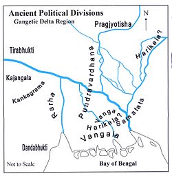
Kajangala (Bengali: কজঙ্গল), refers to a territory located near Rajmahal in ancient times, in eastern part of India.[1]
Extent[]
It was spread across what is now part of Birbhum district in West Bengal and Santhal Parganas in Jharkhand.[2]
History[]
The Pali Vinayaka-pitaka fixed the eastern limit of Aryavarta (land of the Aryans) at Kajangala.[3]
References[]
^Majumdar, Dr. R.C., History of Ancient Bengal, First published 1971, Reprint 2005, p. 64, Tulshi Prakashani, Kolkata, ISBN81-89118-01-3.
^Roy, Niharranjan, Bangalir Itihas, Adi Parba, (in Bengali), first published 1972, reprint 2005, pp. 99-100, 81-93, Dey’s Publishing, 13 Bankim Chatterjee Street, Kolkata, ISBN81-7079-270-3