Kalbsrieth
Kalbsrieth | |
|---|---|
show Location of Kalbsrieth within Kyffhäuserkreis district | |
 Kalbsrieth | |
| Coordinates: 51°20′34″N 11°20′13″E / 51.34278°N 11.33694°ECoordinates: 51°20′34″N 11°20′13″E / 51.34278°N 11.33694°E | |
| Country | Germany |
| State | Thuringia |
| District | Kyffhäuserkreis |
| Government | |
| • Mayor (2016–22) | Uwe Ludwig[1] |
| Area | |
| • Total | 11.94 km2 (4.61 sq mi) |
| Elevation | 121 m (397 ft) |
| Population (2020-12-31)[2] | |
| • Total | 628 |
| • Density | 53/km2 (140/sq mi) |
| Time zone | UTC+01:00 (CET) |
| • Summer (DST) | UTC+02:00 (CEST) |
| Postal codes | 06556 |
| Dialling codes | 0 34 66 |
| Vehicle registration | KYF |


Kalbsrieth is a municipality in the district Kyffhäuserkreis, in Thuringia, Germany.
History[]
This section is empty. You can help by . (June 2019) |
Historical Population[]
Population as of 31 December:
|
|
|
|
- Data source: Thuringian Statistical Bureau of State
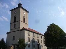
St. Johannis, Village Chapel

Some trees in the castle park
References[]
- ^ Gewählte Bürgermeister - aktuelle Landesübersicht, Freistaat Thüringen, accessed 13 July 2021.
- ^ "Bevölkerung der Gemeinden, erfüllenden Gemeinden und Verwaltungsgemeinschaften in Thüringen Gebietsstand: 31.12.2020". Thüringer Landesamt für Statistik (in German). June 2021.
| show Towns and municipalities in Kyffhäuserkreis |
|---|
| Authority control |
|---|
This Kyffhäuserkreis location article is a stub. You can help Wikipedia by . |
Categories:
- Municipalities in Thuringia
- Kyffhäuserkreis
- Bezirk Halle
- Thuringia geography stubs