Kamhi Point
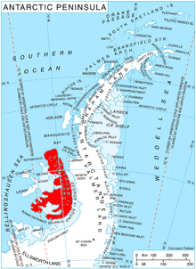
Kamhi Point (Bulgarian: нос Камхи, ‘Nos Kamhi’ \'nos kam-'hi\) is the sharp rocky point on the northwest coast of Alexander Island in Antarctica projecting 450 m westwards into Lazarev Bay south of the terminus of Oselna Glacier.
The feature is named after Rafael Moshe Kamhi (1870-1970), a leader of the Bulgarian liberation movement in Macedonia.
Location[]
Kamhi Point is located at 69°17′57.7″S 72°02′36″W / 69.299361°S 72.04333°WCoordinates: 69°17′57.7″S 72°02′36″W / 69.299361°S 72.04333°W, which is 19.17 km south-southeast of Cape Vostok, 8.8 km southeast of Buneva Point, 6.17 km northwest of Goleminov Point and 1 km northeast of Umber Island. British mapping in 1991.
 WikiMiniAtlas
Maps[]
- British Antarctic Territory. Scale 1:250000 topographic map. Sheet SR19-20/5. APC UK, 1991
- Antarctic Digital Database (ADD). Scale 1:250000 topographic map of Antarctica. Scientific Committee on Antarctic Research (SCAR). Since 1993, regularly upgraded and updated
References[]
- Bulgarian Antarctic Gazetteer. Antarctic Place-names Commission. (details in Bulgarian, basic data in English)
- Kamhi Point. SCAR Composite Gazetteer of Antarctica
External links[]
- Kamhi Point. Copernix satellite image
This article includes information from the Antarctic Place-names Commission of Bulgaria which is used with permission.
This Alexander Island location article is a stub. You can help Wikipedia by . |
- Headlands of Alexander Island
- Bulgaria and the Antarctic
- Alexander Island geography stubs