Umber Island
This article does not cite any sources. (June 2014) |
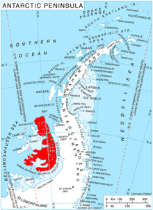
Umber Island (69°13′S 72°0′W / 69.217°S 72.000°WCoordinates: 69°13′S 72°0′W / 69.217°S 72.000°W) is a rocky island, 2.4 km (1.5 miles) long, lying 1.75 km (1.09 mi) southwest of Kamhi Point and 10 km (6 miles) northwest of Dint Island lying within Lazarev Bay, off the west side of Alexander Island, Antarctica. The island was mapped from air photos taken by the Ronne Antarctic Research Expedition (RARE) in 1947–48, by Searle of the Falkland Islands Dependencies Survey in 1960, it was so named by the United Kingdom Antarctic Place-Names Committee because on the RARE photos the island appears in deep shadow cast by the Havre Mountains to the north.
 WikiMiniAtlas
See also[]
- List of Antarctic and sub-Antarctic islands
- Dorsey Island
- Merger Island
- Stoltz Island
![]() This article incorporates public domain material from the United States Geological Survey document: "Umber Island". (content from the Geographic Names Information System)
This article incorporates public domain material from the United States Geological Survey document: "Umber Island". (content from the Geographic Names Information System) ![]()
This Alexander Island location article is a stub. You can help Wikipedia by . |
- Islands of Alexander Island
- Alexander Island geography stubs