Kampot province
Kampot
ខេត្តកំពត | |
|---|---|
| Kampot province | |
    | |
|
Seal | |
 Map of Cambodia highlighting Kampot | |
| Coordinates: 10°36′N 104°10′E / 10.600°N 104.167°ECoordinates: 10°36′N 104°10′E / 10.600°N 104.167°E | |
| Country | |
| Provincial status | 20 August 1923 |
| Capital | Kampot |
| Government | |
| • Governor | Mao Thonin (CPP) |
| Area | |
| • Total | 4,873 km2 (1,881 sq mi) |
| Area rank | Ranked 17th |
| Population (2019)[1] | |
| • Total | |
| • Rank | 12th |
| • Density | 122/km2 (320/sq mi) |
| • Density rank | 12th |
| Time zone | UTC+7 (ICT) |
| Dialing code | +855 |
| ISO 3166 code | KH-7 |
| Districts | 8 |
| Communes | 92 |
| Villages | 477 |
| Website | kampot |

Kampot (Khmer: ខេត្តកំពត, [kʰaet kɑmpɔːt]) is a province (khaet) in southwestern of Cambodia. It borders the provinces of Koh Kong and Kampong Speu to the north, Takeo and Kep and Vietnam to the east and Sihanoukville to the west. To its south it has a coastline of around 45 km on the Gulf of Thailand.[2] It is rich in low arable lands and has abundant natural resources. Its capital is Kampot town.
Kampot province had a population of 627,884[3] in 2010 and consist of eight districts divided into 92 communes with a total of 477 villages.[4] Touk Meas City is located in Kampot province.
History[]
Under 19th century French colonial administration, Kampot became a regional administrative center with the status of a state border district as a result of the delimitation of the Kingdom of Cambodia. The Circonscription Résidentielle de Kampot contained the arrondissements of Kampot, Kompong-Som, Trang and Kong-Pisey.[5][6]
In 1889, French colonial census reports a multi-ethnic community: Kampot town consisted of "Cambodian Kampot" on the Prek-Kampot River and "Chinese Kampot" on the right riverbank of the west branch of the Prek-Thom River. Nearby was also a Vietnamese village, called Tien-Thanh and another Vietnamese village on Traeuy Koh Island. A Malay also existed on Traeuy Koh Island. Additional villages of mixed ethnicity are listed.[7]
Khmer Rouge era[]
Destruction and mass murder happened throughout the whole area of Kampot province, as the Cambodian genocide and bloody massacres engulfed Kampot province under the terror of Khmer Rouge rule. A total 90,450 persons were massacred throughout the province.[8] Ta Mok himself massacred 30,000 people in the Angkor Chey District of Kampot.
Economy[]
Agriculture[]
- Kampot Black Pepper is a specialized product, protected by GI law, totaling 13 ha and a harvesting area of 10.50 ha located in Domnak Kantoul, Kang Tboung Commune, Kompong Trach District.
- Durian, another specialized product totaling 537 ha and yielding 10,657 tons located in Makbrang Commune, Tek Chhou district.
- Rubber, plantation area: 20 ha
- Cambodia sea salt: produced from natural sea water in a four-stage production process, cultivation area is 4,475.94 hectares, yields are approximately 140,000 tons per year.
Forestry and mining[]
- Forestry area: 227,154 ha
- 48 Mineral production and mining areas
Tourism[]
- Historical/cultural areas: 4 places
- Wildlife sanctuaries and protected areas: Preah Monivong National Park at 140,000 hectares[9]
Districts[]
The province is subdivided into 7 districts and 1 municipality.
| ISO code | District | Khmer | Population (2019)[10] |
|---|---|---|---|
| 07-01 | Angkor Chey | ស្រុកអង្គរជ័យ | 73,550 |
| 07-02 | Banteay Meas | ស្រុកបន្ទាយមាស | 78,828 |
| 07-03 | Chhouk | ស្រុកឈូក | 102,298 |
| 07-04 | Chum Kiri | ស្រុកជុំគិរី | 48,764 |
| 07-05 | Dang Tong | ស្រុកដងទង់ | 56,025 |
| 07-06 | Kampong Trach | ស្រុកកំពង់ត្រាច | 86,444 |
| 07-07 | Tuek Chhou | ស្រុកទឹកឈូ | 110,104 |
| 07-08 | Kampot Municipality | ក្រុងកំពត | 32,053 |
Gallery[]

Map of Kampot province

View of the coast near Kampot from Bokor mountain (Phnom Bokor).
The Dâmrei Mountains receives heavy monsoon rainfalls, but keeps the eastern parts of the province in relative rain shadow.

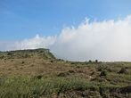
The highland plateaus in Phnom Bokor National Park

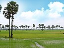
Farmlands
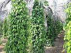
Kampot pepper farm
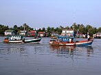
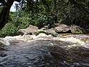
Fishing boats on Kampot River

Cave temple (Phnom Chhnork) near Kampot city
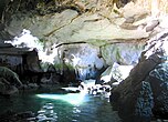
Caves in Kampong Trach

Islands and sandy beaches


References[]
- ^ "General Population Census of the Kingdom of Cambodia 2019 – Final Results" (PDF). National Institute of Statistics. Ministry of Planning. 26 January 2021. Retrieved 3 February 2021.
- ^ "A List of Cambodian Islands". Visit Koh Rong. 2019-10-26. Retrieved 2019-11-12.
- ^ Kampot Data Book 2009 (PDF). National Committee for Sub-National Democratic Development (NCDD). October 2009. p. 15. Archived from the original (PDF) on 2012-04-30. Retrieved 2011-10-27.
- ^ General Population Census of Cambodia, 1998: Village Gazetteer. National Institute of Statistics. February 2000. pp. xviii.
- ^ "Kampot of the Belle Époque: From the Outlet of Cambodia to a Colonial Resort - After colonization by the French..." (PDF). Center for Southeast Asian Studies, Kyoto. Retrieved December 26, 2015.
- ^ "The History of the Vinh Te Canal". UNREPRESENTED NATIONS AND PEOPLES ORGANIZATION. January 27, 2004. Retrieved December 26, 2015.
- ^ "Kampot of the Belle Époque: From the Outlet of Cambodia to a Colonial Resort - When the French installed the Résidence,..." (PDF). Center for Southeast Asian Studies, Kyoto. Retrieved December 26, 2015.
- ^ "The Muslim World League Journal". November 1982.
- ^ "Kampot Province". Cambodia Advisor. Retrieved 5 May 2016.
- ^ https://www.nis.gov.kh/nis/Census2019/Final%20General%20Population%20Census%202019-English.pdf
External links[]
| Wikimedia Commons has media related to Kampot Province. |
Places adjacent to Kampot province | ||||||||||||||||
|---|---|---|---|---|---|---|---|---|---|---|---|---|---|---|---|---|
| ||||||||||||||||
| Autonomous municipality | ||
|---|---|---|
| Provinces | ||
Capital: Kampot | ||
| Districts |  | |
| Places | ||
- Kampot Province
- Provinces of Cambodia
- Gulf of Thailand
- States and territories established in 1923