Kandoora
Kondur
كۄنڈۄر | |
|---|---|
| Kandoora | |
 | |
 Kondur | |
| Coordinates: 33°59′32″N 74°35′01″E / 33.9923°N 74.5837°E | |
| Country | |
| Union Territory | Jammu and Kashmir |
| District | Budgam District |
| Subdistrict | Beerwah |
| Founded by | Sayar Kandurie |
| Named for | Plenty of Stones / Nature of People |
| Village Council | Panchayat House Kandoora |
| Government | |
| • Type | Panchayat House Kandoora |
| • Body | Panchayat Samiti |
| • Moqdam | AB LATEEF SHEIKH |
| • Sarpanch | Muzaffer Ahmed Bhat |
| Area | |
| • Total | 200 ha (500 acres) |
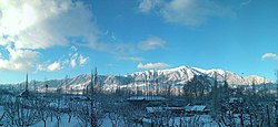
| Elevation | 1,580 m (5,180 ft) |
| Highest elevation (Bhag de Shafie) | 1,616 m (5,302 ft) |
| Lowest elevation (Mahal) | 1,520 m (4,990 ft) |
| Population (2020) | |
| • Total | 3,700 |
| • Density | 825/km2 (2,140/sq mi) |
| Demonym(s) | Kashmiris,Kandoorians Or Kondreek کۄٚنٛڈُۄرؠکؠ |
| Languages | |
| • Official | Kashmiri, Urdu,English[1][2] Arabic |
| Language | |
| • Spoken | Kashmiri |
| Time zone | UTC+5:30 (IST) |
| PIN INDIA | 193411 |
| Vehicle registration | JK04 |

Kondur or Kandoora (in Kashmiri: کۄٚنٛڈُر; in Urdu: کنڈوراہ) is the largest village in the Sukhnag River valley, located on the eastern banks of the Sukhnag River. It lies on the Beerwah-to-Doodhpathri road and is 26 kilometres (16 mi) from Srinagar, the largest city and summer capital of the union territory of Jammu and Kashmir,[3] which is the southern portion of the wider Indian-administered Kashmir region.
Nearest to Kandoora is Beerwah, approximately 2 kilometres (1.2 mi) distant (measured from Beerwah's bus stand), and the Beerwah Tehsil headquarters, about 3 kilometres (1.9 mi) away. Beerwah, along with Sodipora, lies to the north of Kandoora. Also neighbouring the village are the surrounding locations of Sonapah to the northeast; Rankipora and Khatiruna to the east; Larbal to the southeast; Peth Zanigaam and Latinae to the south; Sail and Bun Zanigaamin to the southwest; Kanigund in the west; and Goriepora and Gohlar to the northwest.[4]
The majority of adult Kandoora residents work in agriculture and its associated occupations. There are a significant number of government employees, and, among young adults, students attending further education.[5]
Administration of Kandoora[]
Governance of Kandoora is by representative democracy. Kandoora is in the Beerwah subdivision of Budgam district, and the village is governed by the local panchayat[6] Its panchayat has 11 members, with each member representing a ward constituency. Each ward has a Ward Representative. The village is governed by a gram panchayat or village council.

Kandoora is internally divided into:
- Neiber Kandoora (Kashmiri: neiber, meaning, spread out or peripheral, as in a settlement) has:
- Hajamabad
- Najarabad
- Brandaker
- Gamudd
- Ghatpur
- Sheikhpur
- Malikpur;
and
- Gamander Kandoora (Kashmiri: gamander, meaning, downtown or central portion) contains:
- Bunpur
- Pethpur
- half Mirpur
- half Hajamabad
- half Najarabad
- central Old Graveyard of Kandoora
- the administrative centre, Masheed-e-Aungun
Colonies Of Kandoora[]
- Community - Zandwan Colney[clarification needed]
- Community - Sheikh ul Alam
- Community - Gousia
- Colony[clarification needed] - Larbal
Economy[]
The economy of Kandoora is generally agrarian, being derived from agriculture and horticultural produce. The horticultural sector is on the rise, with the help of Sher-e-Kashmir University of Agricultural Sciences and Technology of Jammu (SKUAST-J) and Sher-e-Kashmir University of Agricultural Sciences and Technology of Kashmir. Many apple orchards are being developed and this sector is expected to boost the economy.
The production and sale of Kashmiri handicrafts, such as Kashmiri shawls, is another avenue for earning income available to Kandoorians.
Demographics, language and culture[]
This section needs expansion. You can help by . (June 2021) |
The village population is 100% Muslim and includes adherents of Sunni Islam, schools of Hanafi, Salafism, and Barelvi branches or schools of Islam.[citation needed]
All disputes are usually sorted out by local Jirga, an assembly of local chieftains of Kandoora. Jirga is a traditional gathering which has been adapted by Kashmiri Muslims from its origins in erstwhile North-West Frontier Province (NWFP) and Afghanistan.[citation needed]
Universally,[citation needed] the mother tongue of Kandoora residents is Koshur (Kashmiri). However, several other languages are occasionally[citation needed] used, including Urdu, English, Persian, Arabic and Hindi.
Etymology[]
The village name, Kandoora, derives from two Kashmiri words: kanie کَنِۂ {transl. stone), and doour ڈُور, (transl. field). As a whole, this gives the meaning, field of stones, and as the name suggests, the village of Kandoora does have plenty of stones in it.[citation needed]
History[]
This section is empty. You can help by . (June 2021) |
Clans[]
The main castes living in Kandoora (without casteism)[clarification needed] include:[citation needed]
- Syed clan
- Sheikh clan
- Mir clan
- Malik clan
- Wani clan
- Hajam clan
- Najar clan
- Ganiee clan
- Parry clan
- Ahanger clan
- Zarger clan
- Pandit clan
- Magrey clan
- Chopan clan
- Malla clan
Religious institutions and organisations[]

The township has halqa level bodies of:
✓ Tehreeq e Soutul Awliya, Jammu and Kashmir
✓ Karwan-I-Islami International, Jammu and Kashmir
✓ Jamiat-e-Ahle Hadith, J&K, Jammu and Kashmir
The village has six masjids, including about 2 jamia masjids[a]:
✓ Grand Jamia Hanafia, Kandoora (in central Masheed-e-Aungun area)
✓ Chanpur Masjid e Shareef (in Chanpur)
✓ Masjid e Ramzaan a mosque of the Hanafi school in Sheikhpur
✓ Masjid e Gousiyah, of the Barelvi school in Diversion[further explanation needed] colony
✓ Jamia Masjid Ahlihadith, in Mirpur
✓ Masjid e Salafiyah, in Ghatpur, a Salafi School masjid
Education[]
The village has a literacy rate of about 79%.[citation needed]
Islamic educational system[]
The village of Kandoora has three Islamic educational institutions:
- Imam e Azam Institute of Islamic Studies, a Hanafi institution
- Institute of Islamic Theology and Jurisprudence (Urdu: درسگاہ تعلیم القران والحدیث نبویہ)
- Shah e Hamdan Institute of Islamic Studies, named in honour of Mir Sayyid Ali Hamadani
Independent schools[]

- Islamic Educational Institute Kandoora™ (IES, Kandoora), established in 1986
This institution is the first private school in valley of the River Sukhnaag.[7]
Post-primary schools[]
- Government Boys Higher Secondary Institute, Kandoora
- Government Girls Middle school, Kandoora
The Government Girls Middle school was established in 1975 in order to educate girls locally, past the primary school level.
The Government Boys Higher Secondary Institute was established in Kandoora 1953 as a primary school. In 1963 it was upgraded to middle school level and then, in 1971, to the high school level. It attained a higher secondary school level in 2018. This higher secondary school feeds Government Degree College, Beerwah. The Institute was only the second school in the area, after the Government Boys Senior Secondary Institute School, Beerwah, established in 1953.
Primary schools[]
- Government Boys Primary School, Chanpur
- Government Boys Primary School, Malik Pur
Area road system[]
Kandoora is well connected to its neighbouring villages by link road. The roads meet internally in the administrative centre, central Kandoora, locally called Masheed-e-Aungun.
The roads are:
- Kandoora-Larbal Link road - 1.5 km (0.93 mi)
- Kandoora-Khatiruna Link road - 1.7 km (1.1 mi)
- Kandoora-Latina Link Road - 1.9 km (1.2 mi)
- Kandoora-Zaniegaam Link Road - 2 km (1.2 mi)
- Kandoora-Rankipora Link Road - 1.8 km (1.1 mi)
- Kandoora-Kaniegund Link Road - 1.7 km (1.1 mi)
- Kandoora-Sail Link Road - 2 km (1.2 mi)
- Kandoora-Sodiepora Link Road - 2.4 km (1.5 mi)
- Kandoora-Arizal Road - 11 km (6.8 mi)
The village can be accessed from:
- Budgam
- Budgam-Kandoora Road, via Sonpah
- Beerwah
- Beerwah-Doodhpathri Road, via Sonpah
- Beerwah-Kandoora Road, via Rankipora
- Khag
- Kandoora-Khag Road, via Malpora and Sail
- Khan Sahib
- Kandoora-Khan Sahib Road, via Pethkoot
The internal road system of the village is very large, but is considered[by whom?] underdeveloped.[citation needed] Some[who?] ascribe this to administrative negligence due to political bias.[neutrality is disputed]
Interior roads include:
- Ghatpur-Masheed e Aungun Street
- The Diversion-Malikpur Street
- The Diversion-Nagpur Street
- The Sheikhpur-Batehar Street
- The Gamudd-Maxelum Street
- The Maxelumm-Aawrenea Street
- The Batehar Street
Notes[]
- ^ Jamia Masjid is the mosque in which muslims observe Friday prayers.
References[]
- ^ "The Jammu and Kashmir Official Languages Act, 2020" (PDF). The Gazette of India. 27 September 2020. Retrieved 27 September 2020.
- ^ "Parliament passes JK Official Languages Bill, 2020". Rising Kashmir. 23 September 2020. Retrieved 30 May 2021.
- ^ Manzoor, Mir (22 September 2018). "Kandoora". Indiatv.
- ^ debu, dangal (29 July 2020). "Kandoora".
- ^ Kandoora, gk (18 April 2019). "Kandoora". The Kashmir Life.
- ^ India tv, News (24 May 2020). "Kandoora". Republic world.
- ^ Directorate of School Education Kashmir
Coordinates: 33°59′32″N 74°35′01″E / 33.9923°N 74.5837°E
External links[]
- Villages in Budgam district
- Kashmir separatist movement
- Kashmir conflict
- Kashmiri people
- Kashmiri language
- Population research organizations