Doodhpathri
Doodhpathri
Dọdü pathür | |
|---|---|
Hill Station | |
| DoodhPathri Development Authority | |

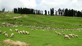 Nature, scenery of Doodhpathri | |
| Nickname(s): Valley Of Milk | |
| Jammu and Kashmir | Jammu and Kashmir |
| District | Budgam |
| Tehsil | Khansahib |
| Named for | White Appearance Of Water |
| Elevation | 2,730 m (8,960 ft) |
| Languages | |
| • Official | Kashmiri, Urdu, Hindi, Dogri, English[1][2] |
| Languages | |
| • Local | Gujari, Pahadi |
| Time zone | UTC+5:30 (IST) |
| Pin Code | 191111 |
| Vehicle registration | JK04 |
Doodhpathri (translation; Valley of Milk) is a tourist destination and a hill station in the Indian administered union territory of Jammu and Kashmir. It is located in area of Budgam district.[3] Situated at an altitude of 2,730 metres (8,960 ft) from sea level, it is located at a distance of 42 km (26 mi) from 's summer capital Srinagar and 22 km (14 mi) from district headquarters Budgam.
History and Etymology[]
The name "doodpathri" means Valley of Milk. It is said that the famous saint of Kashmir Sheikh ul Aalam Sheikh Noor din Noorani has prayed here and once when he was in search of water in the meadows, to offer prayers, he pricked the ground with his stick to search for water and milk came out. He asked the milk that you can only be used for drinking and not performing ablution. Hearing this milk at once changed its state to water and the meadow got its name Doodpathri. The water which is at present flowing through the meadows has a milky appearance from the distance and remains very cold throughout the year. The lush green grasses over the vast meadows and silver shining streams running over the large stones further increase its beauty. Doodhpathri is sloping grassy landscapes with a diversity of multicolored flowers up to Chang. The famous Tosamaidan lies in the west of Doodpathri.[4]
Geography[]
Doodhpathri lies in a bowl shaped valley in the Pir Panjal Range of the Himalayas, at an altitude of 2,730 m (8,957 ft) above sea level. It is an alpine valley covered with snow clad mountains and the meadows of Pine Fir and Deodar. The natural meadows, which are covered with snow in winter, allow the growth of wild flowers such as daisies, forget-me-nots and butter cups during spring and summer.
Demographics[]
Doodhpathri has no permanent settlement and is inaccessible during winter due to heavy snowfall. In summer shepherds from the plains of district Budgam bring cattle for grazing and remain at Doodhpathri seasonally for about six months.
Access[]
Doodhpathri is easily accessible from Srinagar or Srinagar Airport (SXR), in under 2–3 hours from car or bus. The routes of doodhpathri are from Srinagar to Budgam, Budgam to Khansahib and Khansahib to Doodhpathri via Raiyar total distance of about 42 km (26 mi).[5][6][7]
By road[]
Doodhpathri is easily accessible from Srinagar in under 1 and Half Hour from car or Taxi. The routes of Doodhpathri are from Srinagar to Budgam, Budgam to Khansahib and Khansahib to Doodhpathri via Raiyar total distance of about 45 km (28 mi). Another route is from Srinagar Gulmarg road,the route starts from Srinagar to Magam, Magam to Beerwah and Beerwah to Doodhpathri via Zaingam & Arizal total distance about 50 km (31 mi).
By air[]
The nearest airport is the Sheikh ul-Alam International Airport (Srinagar, Jammu and Kashmir). Doodhpathri is at a distance of 40 km From this Airport and it takes about 1 hour by Car.
Places around Doodhpathri[]
Main attraction of Doodhpathri is Tangnar, Mujpather, Dophkhal, Sochilpather, Palmaidan and Parihas.
- Tangnarٹنٚگٕہ نار: (Lit; Gorge Of Pears) This place comes on the way 2 km (1.2 mi) before doodpathri,it is a beautiful place of small valleys with deaodar and pine trees on small hills.
- Mujpathriمُجِہ پَتھٕر: Mujpathri (translation:Valley of Turnip) is a small hamlet 3 km (1.9 mi) from doodpathri, it is situated on the bank of river shaliganga.
- Palmaidanپَلۂ مآٔدآن : Palmaidan (translation:Big stones ground) the name of this place is after the "Big Stones" because there are huge stones all around the ground. It situated at a distance of about 5 km (3.1 mi) from Doodpathri and is the favorite spot of shepherds and cowboys where shepherds and cowboys gather in large numbers in summer and graze their cattle and livestock. It is beautiful place with a small stream running on one side of the ground. The place is rich in deodar and pine trees.
- Diskhal ڈِسکُھل: Dikshal is a beautiful meadow on the top of the mountain and overlooks the Ashtaar glacier. It is around 10 km (6.2 mi) trek from Shaliganga Nallah in Dodhpathri.
References[]
- ^ "The Jammu and Kashmir Official Languages Act, 2020" (PDF). The Gazette of India. 27 September 2020. Retrieved 27 September 2020.
- ^ "Parliament passes JK Official Languages Bill, 2020". Rising Kashmir. 23 September 2020. Retrieved 30 May 2021.
- ^ ":: District Budgam (Official website)". budgam.nic.in. Retrieved 2015-10-13.
- ^ "The unexplored wealth of Doodhpathri". www.greaterkashmir.com. Retrieved 2015-10-13.
- ^ "Doodhpathri". www.daletravels.net. Retrieved 2015-10-13.
- ^ "Unexplored Doodhpathri". kashmirscan.net. Archived from the original on 2013-12-16. Retrieved 2015-10-13.
- ^ "Doodhpathri". budgam.nic.in. Retrieved 14 January 2021.
- ^ Doodhpathri
| Subdivisions | |
|---|---|
| Municipalities | |
| Tehsils | |
| Blocks | |
| Tourist attractions | |
| Villages |
|
| Railway | |
| Airport |
|
<ref>{https://www.myfeeling.in/2021/12/httpswww.myfeeling.in202112doodhphatri-kashmir_0453203935.html}
- Budgam district
- Hill stations in Jammu and Kashmir