Kareri Lake
This article needs additional citations for verification. (February 2022) |
| Kareri Lake (Kumarwah Lake) | |
|---|---|
 Kareri Lake | |
 Kareri Lake (Kumarwah Lake) | |
| Location | Kangra district |
| Coordinates | 32°19′32″N 76°16′25″E / 32.32556°N 76.27361°ECoordinates: 32°19′32″N 76°16′25″E / 32.32556°N 76.27361°E |
| Lake type | High altitude lake |
| Primary inflows | Mankiani Peak |
| Primary outflows | Nyund Stream |
| Basin countries | India |
| Surface elevation | 2,934 m (9,626 ft) |
| References | Himachal Pradesh Tourism Dep. |

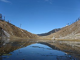
Kareri Lake is a high altitude, shallow, fresh water lake south of the Dhauladhar range approximately 9 km North West of Dharamsala in Kangra district, Himachal Pradesh.[1]
Geography[]
Kareri Lake is at elevation 2934 meters above the sea level. Snow melting from the Dhauladhar range serves as the source of the lake and a stream, is the outflow. Since the source is fresh melting snow and the lake is shallow, water visibility is very high and in most places, the lake bed can be seen. The lake remains frozen from early December to March–April.
Tourism[]
Kareri lake is best known for being a trekking destination in the Dhauladhars. There is a temple dedicated to Lord Shiva and Shakti on a hilltop overlooking the lake. A few Gaddi kothis are present on the other side of the lake, an area which is used by the gaddis as a grazing ground for their animals. Kareri Lake serves as a base for trekking further into the Dhauladhar and onward to Chamba and Bharmour via the (4250m) and (3710m).
Etymology[]
Kareri Lake is named after the nearby Gaddi village of Kareri, situated 9 km south east of the lake.
References[]
Lakes of Himachal Pradesh | |
|---|---|
| Low-altitude lakes | |
| Mid-altitude lakes | |
| High-altitude lakes | |
| Reservoirs | |
| Related topics |
|
- Lakes of Himachal Pradesh
- Geography of Kangra district