Kassala
Kassala
كسلا | |
|---|---|
Town | |
 | |
 Kassala Location in Sudan | |
| Coordinates: 15°27′N 36°24′E / 15.450°N 36.400°E | |
| Country | |
| State | Kassala State |
| Population (2008) | |
| • Total | 419,030 |

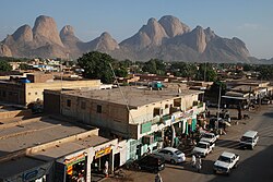
Kassala (Arabic: كسلا) is the capital of the state of Kassala in eastern Sudan. Its 2008 population was recorded to be 419,030.[1] Built on the banks of the Gash River, it is a market town and is famous for its fruit gardens.
Many of its inhabitants are from the Hadendawa origin in addition to a small group of Rashaida nomads and Beni-Amer group, with others being of , Tigre, and Bilen who migrated from Eritrea in the last three decades.
The town was formerly a railroad hub, however, as of 2006 there was no operational railway station in Kassala and much of the track leading to and from the town has been salvaged or fallen into disrepair. Kassala's location along the main Khartoum-Port Sudan highway makes it an important trade center.
History[]

In the 18th and 19th centuries, the town was a key node in the west–east trade route, linking the coastal ports of Massawa and Suakin with the Sudan and farther west.[2] The town was conquered by Ottoman soldiers of Egyptian viceroy Muhammad Ali in 1840 during his military offensive into Sudan. In 1885, Kassala was subsequently captured by the Mahdists. In 1894, after the Battle of Kassala the Italians captured the city from the Mahdists. In 1897, the Kingdom of Italy returned Kassala to the Kingdom of Egypt under British leadership,[3] in order to get international recognition of the Italian colony of Eritrea. In 1899, Kassala fell under the purview of Anglo-Egyptian Sudan until Sudanese independence in 1956.
In July 1940, during the East African Campaign, Italian forces advancing from Italian East Africa forced the local British garrison to withdraw from Kassala. The Italians then occupied the city with brigade-sized units:[4] indeed on July 4, 1940 the Italians started their offensive with 2,500 men (and one brigade of cavalry) supported by 24 tanks, while to defend Kassala for Britain there were 1,300 colonial soldiers with their British officers who -after some initial heavy fighting- were easily defeated. The Italians later appointed as mayor of Kassala the future hero of Eritrean independence, Hamid Idris Awate. In mid-January 1941, the Italians withdrew from the city and a British garrison returned.
Climate[]
Kassala has a hot desert climate (Köppen climate classification BWh).
| hideClimate data for Kassala (1961-1990, extremes 1901-present) | |||||||||||||
|---|---|---|---|---|---|---|---|---|---|---|---|---|---|
| Month | Jan | Feb | Mar | Apr | May | Jun | Jul | Aug | Sep | Oct | Nov | Dec | Year |
| Record high °C (°F) | 41.7 (107.1) |
43.5 (110.3) |
45.3 (113.5) |
46.0 (114.8) |
47.0 (116.6) |
47.6 (117.7) |
42.5 (108.5) |
41.6 (106.9) |
43.0 (109.4) |
47.0 (116.6) |
41.1 (106.0) |
40.2 (104.4) |
47.6 (117.7) |
| Average high °C (°F) | 33.7 (92.7) |
35.2 (95.4) |
38.3 (100.9) |
40.8 (105.4) |
41.6 (106.9) |
39.8 (103.6) |
36.1 (97.0) |
34.9 (94.8) |
36.8 (98.2) |
38.7 (101.7) |
37.0 (98.6) |
34.4 (93.9) |
37.3 (99.1) |
| Daily mean °C (°F) | 25.1 (77.2) |
26.2 (79.2) |
29.2 (84.6) |
31.9 (89.4) |
33.7 (92.7) |
32.7 (90.9) |
30.0 (86.0) |
29.1 (84.4) |
30.4 (86.7) |
31.5 (88.7) |
29.2 (84.6) |
26.1 (79.0) |
29.6 (85.3) |
| Average low °C (°F) | 16.5 (61.7) |
17.2 (63.0) |
20.1 (68.2) |
23.0 (73.4) |
25.8 (78.4) |
25.7 (78.3) |
23.9 (75.0) |
23.4 (74.1) |
24.0 (75.2) |
24.3 (75.7) |
21.4 (70.5) |
17.9 (64.2) |
21.9 (71.4) |
| Record low °C (°F) | 5.0 (41.0) |
7.4 (45.3) |
8.9 (48.0) |
11.1 (52.0) |
16.2 (61.2) |
18.5 (65.3) |
18.4 (65.1) |
17.2 (63.0) |
18.0 (64.4) |
15.7 (60.3) |
11.1 (52.0) |
6.4 (43.5) |
5.0 (41.0) |
| Average rainfall mm (inches) | 0.0 (0.0) |
0.0 (0.0) |
0.3 (0.01) |
2.0 (0.08) |
8.8 (0.35) |
27.9 (1.10) |
76.0 (2.99) |
85.0 (3.35) |
40.5 (1.59) |
9.9 (0.39) |
0.8 (0.03) |
0.0 (0.0) |
251.2 (9.89) |
| Average rainy days (≥ 0.1 mm) | 0.1 | 0.0 | 0.1 | 0.6 | 2.0 | 3.5 | 7.7 | 8.9 | 4.4 | 1.6 | 0.2 | 0.0 | 29.1 |
| Average relative humidity (%) | 46 | 40 | 33 | 27 | 30 | 39 | 55 | 60 | 54 | 42 | 41 | 46 | 42.8 |
| Mean monthly sunshine hours | 306.9 | 288.4 | 313.1 | 315.0 | 310.0 | 282.0 | 266.6 | 266.6 | 288.0 | 310.0 | 303.0 | 297.6 | 3,547.2 |
| Percent possible sunshine | 88 | 88 | 83 | 84 | 77 | 70 | 67 | 69 | 79 | 84 | 88 | 87 | 80 |
| Source 1: NOAA[5] | |||||||||||||
| Source 2: Meteo Climat (record highs and lows)[6] | |||||||||||||
Current status[]


The Kassala region had a child mortality rate of 62 deaths per 1,000 live births in 2014, slightly higher than the national average of 52 child deaths per 1,000.[7]
The , build in 1840 by the Ottomans and damaged during the Mahdist War, is the city's most important cultural site. It is an important site for the Sufi Khatmiyya order.

Education[]
The city is home to Kassala University, a public university established in 1990 to replace the East University, and an important institution for development in the east of Sudan.[8] Including Faculty of Medicine and Health Sciences, Faculty of Education,Faculty of Economic and Administration, Faculty of Computer science and IT and more.
Notable people[]
- Bushara Abdel-Nadief (Footballer)
- Aisha Musa Ahmad (Singer)
- Hassan Al-Turabi (Politician)
- Muhannad El Tahir (Footballer)
- Nizar Hamid (Footballer)
- Noor Uthman Muhammed
- Dua Saleh (Singer)
See also[]
References[]
- ^ "GeoHive". Archived from the original on 2006-10-21. Retrieved 2007-02-08.
- ^ Miran, Jonathan. "Red Sea Citizens." Indiana University Press, 2009. Page, 87
- ^ Winston Churchill, The River War, Longman 1899 vol.1 pp.354-6
- ^ Map showing in detail the Kassala occupation by Italians (within a green line)
- ^ "Kassala Climate Normals 1961-1990". National Oceanic and Atmospheric Administration. Retrieved January 18, 2016.
- ^ "Station Kassala" (in French). Meteo Climat. Retrieved 22 October 2016.
- ^ "MICS survey – Table CM.2".
- ^ "Kassala University". Sudan Daily Vision. Retrieved 2011-09-17.
External links[]
| Wikivoyage has a travel guide for Kassala. |
| Wikimedia Commons has media related to Kassala. |
| show Authority control |
|---|
- State capitals in Sudan
- Populated places in Kassala (state)