Kazungula

Kazungula is a small border town in Zambia, lying on the north bank of the Zambezi River about 70 kilometres (45 mi) west of Livingstone on the M10 Road.
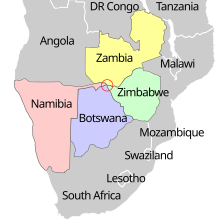
At Kazungula, the territories of four countries (Zambia, Botswana, Zimbabwe, and Namibia) come close to meeting at a quadripoint. It has now been agreed that the international boundaries contain two tripoints joined by a short line roughly 150 metres (490 ft) long forming a boundary between Zambia and Botswana, now crossed by the Kazungula Bridge. The ever-shifting river channels and the lack of any known agreements addressing the issue before 2000 led to some uncertainty in the past as to whether or not a quadripoint legally existed.[1][2] Thus, Botswana has only about 150 metres (490 ft) of river frontage on the Zambezi, being sandwiched on the south bank between the extreme tip of Namibia's Caprivi Strip and Zimbabwe.
The Chobe River, which divides Namibia and Botswana, enters the Zambezi near Kazungula. Kazungula is an important trade destination to both Zambia and Botswana.
Transport[]
Kazungula Bridge is a road and rail bridge over the Zambezi river between the countries of Zambia and Botswana at Kazungula.
The bridge was opened for traffic on 10 May 2021 replacing the exiting ferry.
The 923-metre-long (3,028 ft) by 18.5-metre-wide (61 ft) bridge has a longest span of 129 metres (423 ft) and links the town of Kazungula in Zambia with Botswana and is curved to avoid the nearby borders of Zimbabwe and Namibia. The bridge has a single-line railway track between two traffic lanes and pavements for pedestrians.
Before the bridge opened the main method to cross the river at Kazungula was the Kazungula Ferry. It crossed the 400 m (1,300 ft) wide Zambezi river to the identically-named village of Kazungula in Botswana, 8 km (5 mi) east of the town of Kasane; it was one of the largest ferries in the region with a capacity of 70 tonnes (69 long tons; 77 short tons).[3][citation needed].[4]
Kazungula lies just 2 km (1.2 mi) from the Livingstone-Sesheke road (M10 Road) which connects to the Katima Mulilo Bridge linking Zambia and Namibia.[5][citation needed]
The border post between Zimbabwe and Botswana, 4.5 km (2.8 mi) (by road) south-east of Kazungula Bridge, is also called Kazungula; it is the most direct route leading to Victoria Falls.[6][citation needed]
General administration[]
Kazungula was elevated to district status in September 1998. Government departments, parastatals, and NGOs operate there in agriculture, forestry and fisheries. The following governments and government departments operate: Council, education, health, police, National Registration, immigration, social welfare, community development and ZESCO.
Political system, governance and traditional leadership[]
The district is covered by one parliamentary constituency and fourteen political wards which include Sikaunzwe, Sekute, Nwezi, Moomba, Nyawa, Nuba, Kauwe and Chooma. Traditionally, the district is divided into five chiefdoms and these are Chief Sekute, Chief Nyawa, Chief Musokotwanwe, Chief Mukuni and Chief Moomba. The main tribes in the district are , Lozi, and Tonga.
Local economy[]
The majority (66%) of the population within Kazungula does not receive any form of income (CSO 2010). The largest industries are peasant/subsistence farming, cross-border trading and fishing. The main economic sectors in Kazungula are agriculture, manufacturing, trade, commerce and tourism.
The informal sector is characterised by fish trading, trading in second hand and new clothes and footwear, small-scale fishing, trading in vegetables and other foodstuffs, beer brewing, carpentry, production and selling of traditional handicrafts, trading in groceries, restaurants, bars and charcoal burning and selling. The major activity in the secondary sector is the generation of power at Batoka Gorge located in Mukuni ward. Other secondary sector activities though of less economic significance are the production of timber and carpentry.
Tourism[]
Tourism is one of the major sectors of Kazunglula's economy. The sector has had positive impact on the economy of the district. Tourism is labour intensive and hence provides employment to a significant number of people. There are several lodges and guest houses in Kazungula Township, along the Zambezi River. However, tourism development still remains far below potential because of challenges of poor and inadequate infrastructure, limited investment, fragmented operations, weak marketing and limited skilled manpower. Despite the fact that the district lies alongside Zambezi river, activities such as boat cruising, gymnasiums and saunas are not available.
Infrastructure development[]
The following projects are at different stages of completion:
- Construction of the Kazungula District Hospital is at 90% under phase one of the project.
- Construction of 30 housing units for government departments is at various stages.
- Construction of Kazungula Bridge has commenced. It is now almost finished.
- The construction of the truck yard superstructure is completed.
- Construction of 10 classroom blocks and 10 VIP toilets.
- Construction of CIVIC Centre is above ring beam while the District Administration is at slab level.
- The construction of the post office is at roof level.
- The local court is completed and operational.
- Construction of Sibandwa Dam.
Agriculture[]
There are currently few commercial farmers in the district. Most of the farming communities in the district are in the category of small-scale farming. There are 10,522 small-scale farmers farming a wide range of crops such as maize, sorghum, millet, groundnuts and cotton. Some farmers have increased their fields to become medium-scale farmers. The crops grown by these farmers include but not limited to maize, sorghum, millet, groundnuts, cotton, cassava and vegetables. Livestock production in Kazungula District is done on a small scale by traditional pastorals. There are a number of livestock species that are reared in Kazungula District but the notable ones include cattle, goats, sheep, donkeys, poultry and pigs.
Water and sanitation[]
In the area of sanitation, improvements under the urban and peri-urban water supply and sanitation are varied, covering the areas of solid waste management and maintenance of water supply schemes. Progress has been made in the area of construction and rehabilitation of boreholes with 30 new boreholes constructed and 32 boreholes rehabilitated in 2016. Kazungula has 380 existing water points which are functional, though water supply and sanitation service coverage are still very low. The majority of the urban population rely on on-site systems.
Energy[]
There are no filling stations in the district. Wood fuel (firewood and charcoal) remains the dominant source of energy in the district, accounting for almost 80 per cent of total energy consumption. Firewood is predominantly consumed by rural households while charcoal is a major source of energy for urban households. The annual loss of forest cover was estimated at 1.2% due to land clearing for agricultural use rather than energy purposes.
See also[]
References[]
- ^ Brownlie, Ian; Ian R. Burns (1979). "Botswana-Zambia (Quadripoint issue)". African Boundaries: A Legal and Diplomatic Encyclopaedia. London: C. Hurst & Co. pp. 1098–1108. ISBN 0-903983-87-7.; summarized at African tripoints: Botswana-Namibia-Zambia by Michael Donner / Jesper Nielsen.
- ^ Akweenda, Sackey (1997-04-23). "VI: Quadripoint Theory". International Law and the Protection of Namibia's Territorial Integrity. Netherlands: Martinus Nijhoff. pp. 201–3. ISBN 90-411-0412-7.
- ^ "Tracks4Africa". Tracks4Africa. Retrieved 2021-05-20.
- ^ "Zambia : Zambia and Botswana officially launched the construction works for Kazungula Bridge across the Zambezi River". LusakaTimes.com. 2014-09-13. Retrieved 2018-08-06.
- ^ "Kazungula Border Post". huyai.com. Retrieved 2021-05-20.
- ^ "Kazungula bridge: A new gateway into Africa". BusinessLIVE. Retrieved 2021-05-20.
| hide Authority control | |
|---|---|
| General |
|
| National libraries | |

- Botswana–Zambia border crossings
- Populated places in Southern Province, Zambia
- Border tripoints