Tripoint
This article needs additional citations for verification. (July 2008) |

A tripoint, trijunction,[1] triple point, or tri-border area is a geographical point at which the boundaries of three countries or subnational entities meet. There are approximately 176 international tripoints.[2] Nearly half are situated in rivers, lakes or seas. On dry land, the exact tripoints may be indicated by markers or pillars, and occasionally by larger monuments.
Usually, the more neighbours a country has, the more international tripoints that country has. China with 16 tripoints and Russia with 11 to 14 lead the list of states by number of tripoints. Within Europe, landlocked Austria has nine tripoints, among them two with Switzerland and Liechtenstein. Island countries such as Japan have no country tripoints (some, like Bahrain and Singapore, have tripoints in the territorial waters), and the same goes for states with only one neighbour state, like Portugal or Lesotho. Likewise, the United States with two neighbour states has no country tripoints; it has a number of tristate points as well as one point where four states meet. Canada, as well, has five tripoints on land where the boundaries of provinces and territories meet, including one quadripoint where four provinces and territories meet.
Border junctions (or "multiple points" or "multipoints" as they are also sometimes called) are most commonly threefold. There are also a number of quadripoints, and a handful of fivefold points, as well as probably unique examples of a sixfold, sevenfold, and eightfold points (see quadripoint § Multipoints of greater numerical complexity). The territorial claims of six countries converge at the south pole in a point of elevenfold complexity, though this is an example of points subject to dispute.
Examples[]
International tripoints include:
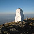
- the Treriksröset of Finland, Norway, and Sweden (the northernmost international tripoint in the world; the exact point is in a lake, but a marker is built on that point)
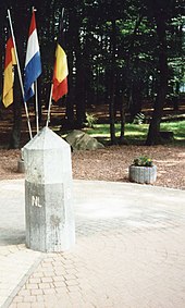
- the Vaalserberg of the Netherlands, Germany, and Belgium
- the "Dreiländereck" of Germany, France, and Switzerland (the exact point is in the river and the marker is not on the exact point)
- the Schengen tripoint of Germany, France, and Luxembourg (where the Schengen Agreement was signed on board a boat, since the tripoint is in the river)
- the summit of Sia Kangri (near Indira Col) is the tripoint where territories administered by India, Pakistan, and China meet.
- the Triple Frontier of Argentina, Brazil, and Paraguay
- the Tres Fronteras of Brazil, Peru, and Colombia
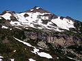
- the Mont Dolent of Italy, France, and Switzerland (the exact point is not at the peak but around 200 metres (700 ft) to the northwest)
- the of Poland, Czech Republic and Slovakia
- Mount Roraima, where Venezuela, Brazil, and Guyana all meet
- Jongsong Peak, the eastern tripoint of China, India and Nepal
- Bratislava is the only capital city in the world which is located at a tripoint: Slovakia, Hungary, and Austria. The city's administrative area extends to the tripoint, but the point lies outside of urban Bratislava itself.
Some historic tripoints:
- the historic Three Emperors' Corner of Austria-Hungary, the Russian Empire, and German Empire
- the historic Piz da las Trais Linguas (Ortler Alps) of Austria-Hungary, the Kingdom of Italy, and Switzerland
- the historic Rock of the Three Kingdoms between the former kingdoms of Galicia, León, and Portugal (now part of the border between Kingdom of Spain and the Portuguese Republic).[3]
- the Tossal dels Tres Reis ('Peak of the Three Kings'), located where the borders of the ancient Kingdoms of Aragon, Valencia and Principality of Catalonia meet.[4]
For a full list, see list of tripoints.
International agreements[]
While the exact line of an international border is normally fixed by a bilateral treaty, the position of the tripoints may need to be settled by a trilateral agreement. For example, China, Russia, and Mongolia have set the position of the two relevant tripoints (the junction points of the China–Russia border, the Mongolia–Russia border, and the China–Mongolia border) by the trilateral agreement signed in Ulaanbaatar on January 27, 1994. The agreement specified that a marker was to be erected at the eastern tripoint, called Tarbagan-Dakh, but that no marker would be erected at the western tripoint (which was defined as the peak of the mountain Tavan-Bogdo-Ula (Kuitunshan, Tavan Bogd Uul).[5]
Gallery[]
This section contains an unencyclopedic or excessive gallery of images. |

Dreiländereck Basel: Switzerland, Germany, and France

Europadenkmal: Germany, Belgium, and Luxembourg

Tripoint of Germany, Czech Republic, and Poland in Sudetes

Tripoint of the Czech Republic (foreground), Poland, and Slovakia

Treriksröset: Finland, Norway, and Sweden tripoint

Arnoldstein: Italy, Slovenia, and Austria tripoint
Border stone on the tripoint of the Czech Republic (foreground), Austria, and Germany

The tripoint of Austria, the Czech Republic, and Slovakia near Hohenau an der March
Border stone on the tripoint of Bulgaria (right of photograph), Greece (left), and North Macedonia, located on the Tumba Peak in the Belasica mountains

The tripoint of France, Italy, and Switzerland is located on Mont Dolent.
The southern tripoint of Switzerland, Liechtenstein, and Austria is located at the Naafkopf.

Border stone on the tripoint of Venezuela (foreground), Brazil, and Guyana located on Mount Roraima

Tripoint of Slovakia, Austria, and Hungary outside the Slovak capital city Bratislava

Ceremonial marker near the tri-point of France, Germany and Luxembourg


See also[]
- List of tripoints
- List of tripoints of English counties
- Tri-state area
- Quadripoint
- Maritime boundary
References[]
- ^ Charney, Jonathan I.; Colson, David A.; Smith, Robert W. (2005). International Maritime Boundaries. Martinus Nijhoff. p. 3298. ISBN 978-90-04-14461-3.
- ^ "JISCMail - INT-BOUNDARIES Archives". www.jiscmail.ac.uk. Retrieved 10 April 2018.
- ^ Treaty on boundaries between Spain and Portugal from the mouth of the Minho River to the junction of the river Cay a with the Guadiana. Signed at Lisbon on 29 September 1864 Archived 19 May 2011 at the Wayback Machine
- ^ "Mapa Topogràfic de Catalunya". Institut Cartogràfic de Catalunya. Retrieved May 22, 2010..
- ^ Соглашением между Правительством Российской Федерации, Правительством Китайской Народной Республики и Правительством Монголии об определении точек стыков государственных границ трех государств (Заключено в г. Улан-Баторе 27 января 1994 года) (The Agreement between the Government of the Russian Federation, the Government of the People's Republic of China, and the Government of Mongolia on the determination of the points of junction of the national borders of the three states)
External links[]
 Media related to Tripoint at Wikimedia Commons
- Penedo dos Três Reinos («The Rock of Three Kingdoms»)
- Tripoint border of China, Russia and North Korea
| Authority control: National libraries |
|---|
- Border tripoints