Tri-state area
This article needs additional citations for verification. (August 2014) |
Tri-state area is an informal term in the eastern contiguous United States for any of several populated areas associated with a particular town or metropolis that, with adjacent suburbs, lies across three states. Some of these involve a state boundary tripoint. Other tri-state areas have a more diffuse population that shares a connected economy and geography—especially with respect to geology, botany, or climate. The term "tri-state area" is often present in radio and television commercials.[citation needed]
Tri-state areas[]
- The Cincinnati metropolitan area, including Ohio, Kentucky, and Indiana.
- The New York metropolitan area, which covers parts of the states of New York, New Jersey, and Connecticut.
- The Philadelphia metropolitan area, which covers parts of the states of Pennsylvania, New Jersey, and Delaware while also including a portion of Maryland's eastern shore.
- The Greater Boston metropolitan area, which covers parts of the states of Massachusetts, Rhode Island, and New Hampshire.
- The Pittsburgh tri-state area, covering parts of Pennsylvania, Ohio, and West Virginia.
- The Minisink Valley tri-state region, which covers Orange County, New York; Sussex County, New Jersey; and Pike County, Pennsylvania.
- The Chicago tri-state area, or Chicagoland, includes northeast Illinois, Northwest Indiana, and southeast Wisconsin. Parts of southwest Michigan in the Michiana region are also culturally tied to Chicago. The Tri-State Tollway connects Illinois' portion of Chicagoland with Northwest Indiana and southeast Wisconsin.
- The Greater Memphis area or Mid-South, includes West Tennessee, Northwest Mississippi, and the Arkansas delta.
- The Dubuque, Iowa tri-state area spills over into Illinois and Wisconsin.
- The La Crosse, Wisconsin, tri-state area includes La Crosse and Onalaska in Wisconsin; La Crescent, Hokah, and Brownsville in Minnesota; and New Albin and Lansing in Iowa.
- The Chattanooga, Tennessee, tri-state area includes portions of Alabama and Georgia.
- The area that includes Washington, D.C. and the nearby parts of Maryland and Virginia is sometimes loosely referred to as a "tri-state area," although the District of Columbia is not a state. However, with the presence of Jefferson County, West Virginia, in the official Washington–Arlington–Alexandria metropolitan statistical area, the region, as defined by the US Government, does in fact include three states. This area is colloquially referred to as "the DMV" (DC, Maryland, Virginia).
- The "Joplin District", a lead and zinc mining region of Oklahoma, Kansas, and Missouri, produces mineral specimens known as "tri-state" minerals, typically consisting mainly of sphalerite.
- The Wiregrass Region includes Southeast Alabama, Southern Georgia, and the Florida Panhandle.
- The Sioux City metropolitan area region of Iowa, Nebraska, and South Dakota.
- Northwest Litchfield County, Connecticut, southern Berkshire County, Massachusetts, and eastern Dutchess County, New York are referred to as a tri-state area or sometimes the "tri-corners".
- The Quincy, Illinois, tri-state area includes parts of Missouri and Iowa.
- The Illinois–Indiana–Kentucky tri-state area includes Evansville, Indiana, and adjacent parts of Illinois and Kentucky.
- The Huntington–Ashland metropolitan area incorporates towns in ten counties in Kentucky, Ohio, and West Virginia. This area is sometimes referred to as “Kyova”, a portmanteau of the state abbreviations.
- The Ark-La-Tex is a socio-economic tri-state region that includes thirty-nine counties/parishes in Arkansas, Louisiana, and Texas.
- The Delmarva area, which includes Delaware and the eastern shores of Maryland and Virginia.
The Quincy, Evansville, and Huntington–Ashland areas are noteworthy for the states included all being separated by rivers.
Tripoints[]
Land[]
Of the 62 points in the United States where three and only three states meet (each of which may be associated with its own tri-state area), 35 are on dry land and 27 are in water.[1]

NY–MA–CT tripoint marker

CT–RI–MA tripoint marker
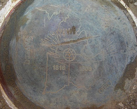
IN–MI–OH tripoint marker
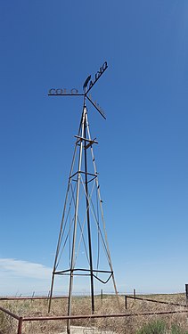
CO–KS–OK tripoint marker (8 Mile Corner)


Water[]
Regions with no tripoint[]
The following tri-state areas are also notable, but have no tripoint:
See also[]
- Four Corners
- Four State Area
- Twin cities (geographical proximity), which includes tri-city
- Quad cities
- Three-Country Cairn
References[]
- ^ "Tri State Corners in the United States" (PDF). Jack Parsell.
- ^ Wheatley, Thomas. "Camak Stone, border marker between Tennessee and Georgia, is missing". Creativeloafing.com. Retrieved May 7, 2017.
- ^ Vardeman, Johnny. "Stolen stone returns home minus fanfare". Gainesville Times. Retrieved May 7, 2017.
- ^ "Arizona–Nevada–Utah" (PDF). Bjbsoftware.com. Retrieved August 27, 2018.
- ^ "Arkansas–Missouri–Oklahoma" (PDF). Bjbsoftware.com. Retrieved August 27, 2018.
- ^ "Oregon–California–Nevada" (PDF). Bjbsoftware.com. Retrieved August 27, 2018.
- ^ "Colorado–Nebraska–Kansas" (PDF). Bjbsoftware.com. Retrieved August 27, 2018.
- ^ "Colorado–Nebraska–Wyoming" (PDF). Bjbsoftware.com. Retrieved August 27, 2018.
- ^ "Colorado–Utah–Wyoming" (PDF). Bjbsoftware.com. Retrieved August 27, 2018.
- ^ "Connecticut–Massachusetts–New York". Bjbsoftware.com. Retrieved August 27, 2018.
- ^ "Connecticut–Massachusetts–Rhode Island". Bjbsoftware.com. Retrieved August 27, 2018.
- ^ "Delaware–Maryland–Pennsylvania". Bjbsoftware.com. Archived from the original on March 19, 2002. Retrieved August 27, 2018.
- ^ "Georgia–North Carolina–Tennessee" (PDF). Bjbsoftware.com. Retrieved August 27, 2018.
- ^ "Idaho–Montana–Wyoming" (PDF). Bjbsoftware.com. Retrieved August 27, 2018.
- ^ "Idaho–Nevada–Oregon" (PDF). Bjbsoftware.com. Retrieved August 27, 2018.
- ^ "Idaho–Nevada–Utah" (PDF). Bjbsoftware.com. Retrieved August 27, 2018.
- ^ "Idaho–Utah–Wyoming" (PDF). Bjbsoftware.com. Retrieved August 27, 2018.
- ^ "Jack Parsell's description of the IN-MI-OH tripoint" (PDF). Bjbsoftware.com. Retrieved August 27, 2018.
- ^ "Geocaching – The Official Global GPS Cache Hunt Site". Geocaching.com. Retrieved August 27, 2018.
- ^ "Photo by Gregg A. Butler of the IA-MN-SD tripoint and its witness post" (JPG). Bjbsoftware.com. Retrieved August 27, 2018.
- ^ "Kansas–Missouri–Oklahoma". Bjbsoftware.com. Retrieved August 27, 2018.
- ^ "KY-TN-VA Tri-State Peak at Cumberland Gap National Historical Park". Nps.gov. Retrieved April 1, 2018.
- ^ "Kentucky–Virginia–West Virginia" (PDF). Bjbsoftware.com. Retrieved August 27, 2018.
- ^ "Maryland–Pennsylvania–West Virginia" (PDF). Bjbsoftware.com. Retrieved August 27, 2018.
- ^ Eric Jones. New Hampshire Curiosities. Globe Pequot, 2006. p. 114-5
- ^ "Massachusetts–New York–Vermont". Bjbsoftware.com. Retrieved August 27, 2018.
- ^ "Montana–North Dakota–South Dakota" (PDF). Bjbsoftware.com. Retrieved August 27, 2018.
- ^ "Montana–South Dakota–Wyoming" (PDF). Bjbsoftware.com. Retrieved August 27, 2018.
- ^ "Nebraska–South Dakota–Wyoming" (PDF). Bjbsoftware.com. Retrieved August 27, 2018.
- ^ "New York–Pennsylvania–New Jersey Tristate" (PDF). Bjbsoftware.com. Retrieved January 14, 2019.
- ^ Graff, Bill (Summer 2006). "Sentinels at the Northern Border" (PDF). Unearthing New Jersey. New Jersey Geological Survey. 2 (2): 1–3.
Tri-States Monument ... this small granite slab serves as both the northern end of our boundary with Pennsylvania and the northwestern end with New York.
- ^ "North Carolina–Tennessee–Virginia" (PDF). Bjbsoftware.com. Retrieved August 27, 2018.
- ^ "Iowa–Minnesota–Wisconsin". Bjbsoftware.com. Retrieved August 27, 2018.
External links[]
- Tripoint Guide
- Clark, Patterson; Lu, Denise (September 17, 2015). "Cornering America's tri-points". The Washington Post. Retrieved October 5, 2016.
- Geography of the United States
- Borders of U.S. states
- Border-related lists
- Border tripoints