Keblov
show This article may be expanded with text translated from the corresponding article in Czech. (July 2009) Click [show] for important translation instructions. |
Keblov | |
|---|---|
Municipality and village | |
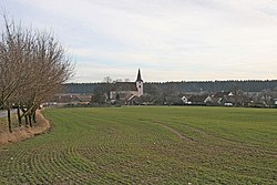 View towards the village | |
 Flag  Coat of arms | |
 Keblov Location in the Czech Republic | |
| Coordinates: 49°41′N 15°04′E / 49.683°N 15.067°ECoordinates: 49°41′N 15°04′E / 49.683°N 15.067°E | |
| Country | |
| Region | Central Bohemian Region |
| District | Benešov District |
| Area | |
| • Total | 2.75 sq mi (7.11 km2) |
| Population (2011) | |
| • Total | 171 |
| Time zone | UTC+1 (CET) |
| • Summer (DST) | UTC+2 (CEST) |

Keblov is a municipality and village in Benešov District in the Central Bohemian Region of the Czech Republic.
History[]
The first written record of the village comes from the year 1295 as property of the Prague Bishops.
Keblov fortress[]
The fortress lay here, the first mention of it is from 1437, when a certain Jan Husovec sold the fortress Zaháj with a court to the burgher Jan Matys from Hostina. The remains of the fortress have been preserved in the forest on the eastern edge of the village. Its remains are a round hill still surrounded by a muddy moat. It was a towering fortress.
Another mention was made in the second half of the 17th century, when it is stated that during the Thirty Years' War it was destroyed and therefore Jan Matys built a replacement wooden fortress in 1670, after which the fortress remained a well. Jan Matys then left the seat and built a brick fortress.
Jan Matys died in 1702 and is buried in the Keblovský church. His tombstone is on the floor of the church.
The Keblov fortress then lost its significance as a manor house and was rebuilt into a granary, and the event disappeared without a trace.
Territorial evolution[]
The history of territorial evolution covers the period from 1850 to the present. The chronological overview shows the territorial administrative affiliation of the municipality in the year in which the change took place:
- 1850 Czech lands, region Pardubice, political district Ledeč, court district Dolní Kralovice[1]
- 1855 Czech lands, region Čáslav, court district Dolní Kralovice
- 1868 Czech land, political district Ledeč, court district Dolní Kralovice
- 1939 Czech lands, Oberlandrat Německý Brod, Ledeč nad Sázavou political district, Dolní Kralovice court district[2]
- 1942 Czech lands, Oberlandrat Tábor, political district Ledeč nad Sázavou, court district Dolní Kralovice[3]
- 1945 Czech lands, administrative district of Ledeč nad Sázavou, court district of Dolní Kralovice [4]
- 1949 Jihlava Region, Ledeč nad Sázavou District[5]
- 1960 Central Bohemian Region, Benešov District
- 2003 Central Bohemian Region, Benešov District, municipality with extended powers Vlašim
1932[]
In the village of Keblov (belonging to Sedlice, 470 inhabitants, post office, Catholic church) the following trades and shops were registered in 1932:[6] production of pumps, 2 inns, blacksmith, Cooperative distillery for Keblov, mill, 2 shoemakers, sawmill, butcher, 3 general stores, Savings and backup association for Keblov, 2 newsagents, 2 carpenters.
References[]
- ^ Administrative arrangement of Předlitavska 1850-1918
- ^ Amtliches Deutsches Ortsbuch für das protektorat Böhmen und Mähren
- ^ Order of the Minister of the Interior No. 185/1942 Sb.
- ^ "Decree of the President of the Republic No. 121/1945 Coll" (PDF). Archived from the original (PDF) on 2011-09-28. Retrieved 2011-09-28.
- ^ "Government Regulation No. 3/1949 Coll" (PDF). Archived from the original (PDF) on 2011-05-22. Retrieved 2011-05-22.
- ^ Directory of the Czechoslovak Republic for Industry, Trades, Trade and Agriculture, compiled and published by Rudolf Mosse, Prague; 1932, Volume I, pp. 559. (Czech and German)
External link[]
 Media related to Keblov at Wikimedia Commons
- This article was initially translated from the Czech Wikipedia.
| Authority control: National libraries |
|---|
- Populated places in Benešov District
- Villages in Benešov District
- Benešov geography stubs