Keilir (mountain)
| Keilir | |
|---|---|
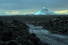 Keilir with the smaller Keilirbörn hills in winter | |
| Highest point | |
| Elevation | 397 m (1,302 ft)[1] |
| Coordinates | 63°56′33″N 22°10′15″W / 63.94250°N 22.17083°WCoordinates: 63°56′33″N 22°10′15″W / 63.94250°N 22.17083°W[2] |
| Geography | |
 Keilir Iceland | |
| Location | Reykjanes Peninsula, Iceland |
| Geology | |
| Mountain type | Subglacial mound or tuya |
| Volcanic arc/belt | Reykjanes Volcanic Belt |
| Last eruption | Pleistocene |
| Climbing | |
| Easiest route | from ENE |


Keilir (Icelandic pronunciation: [ˈcʰeiːlɪr̥]; 378 m asl) is a Pleistocene subglacial mound or perhaps a conical tuya[3] on Reykjanes Peninsula in Iceland.[4] Basal area is 0.773 km2, summit area 0.004 km2, basal width 0.99 km, summit width 0.07 km, volume 0.0362 km3.[3]
It is located within the area of Krýsuvík volcanic system[5] and . It is about 17 miles southwest of the capital city Reykjavík,
In March 2021 the mountain began to emit earthquakes followed by a fissure lava eruption further southwest at Fagradalsfjall.
2021 Keilir volcanic eruption[]
On 3 March 2021 scientists in Iceland reported several days of seismic activity from the mountain. They said this was a "strong sign" that a volcanic eruption may be imminent. This would be the first in the area since the 12th century.[6]
After weeks of tremors a small lava eruption began flowing from a fissure on 19 March 2021.[7][8]
The eruption is in a valley bottom is mostly lava and sulphur dioxide gas and it is not expected to impact on air traffic or population centres.[citation needed]
Scientists studying the area have said that past eruptions from the volcano have been prolonged with intermittent eruptions expected to follow for around 100 years.[citation needed]
The Reykjanes Peninsula is a portion of the continuously spreading Mid-Atlantic Ridge that is permanently above sea level. The location is easily reached and the eruption is expected to be intensively studied by volcanologists.[9]
Formation[]
Keilir was formed during a subglacial fissure eruption which concentrated in the end at one vent.[10] Except the cone, also some small subglacially formed hills to the north are results of this eruption.[11][10]
Eruptions under the Weichselian glaciers on Reykjanes Peninsula[]
When stratigraphy is considered in detail, it tells about the different parts of this eruption: The eruption thawed the glacier ice and formed a subglacial lake in which the volcano continued to develop. The water very soon touched the magma within the vent and caused explosive activity. Tephra set down in layers into the subglacial lake. With time, the tephra built up a hill and small elongated mountain over the vent(s). When such an eruption is continued over a longer time span, the water in the end does not reach the vent(s) any more and lava begins to flow.[10]
In the top region of Keilir, there is a small cap of lava (area of lava cap 0,020 km2[3]) which could mean that the volcanic mountain is a tuya (the lava being from subaerial eruptions at the end of the eruption series)[3] or perhaps just represents a volcanic plug (the lava cooled and plugged up the vent).[10]
Ice thickness and more exact time of eruption in the case of Keilir are not known, just that it took place during the Pleistocene (Weichselian).[10]
Comparison to an Antarctic subglacial tuff cone[]
Smellie and other scientists newly discovered a similar monogenetic subglacial tuff cone within the ice of Antarctica and could determine the thickness of ice which covered the vent during eruption. The Antarctic cone did lie under a polar ice sheet and not a temperate glacier as was the case with Keilir. Additionally, the Antarctic cone is much older (around 640 000 years), whereas Keilir is up to 100 000 years old. And the tuff cone from Victoria Land, Antarctica, is placed next to known granitic plutonic complexes and seems to be a parasitic cone of a stratovolcano, whereas Keilir is located adjacent to presently active volcanic systems and looks as if it were placed on top of the shield volcano , though the last one is younger than the subglacial formation. Interestingly,[editorializing] similar tectonics, rift zones, are behind both expressions of volcanism: the West Antarctic Rift System on the one hand,[12] and in the case of Keilir the Reykjanes Rift as part of the rift zones crossing Iceland. Also similar are their rocks – mafic lapilli tuff (in Icelandic: móberg).[12][13]
Landmark[]
As the mountain is easily recognized from afar, eg. from Reykjavík, but also from sea, it was used as a landmark by fishermen and seamen for many centuries.[4]
Hiking[]
There is a hiking trail leading up on the mountain from ENE. At the top, a guestbook can be found within a box.[11]
An excellent view over a big part of Reykjanes Peninsula and Faxaflói is to be expected from the top in good weather.[11]
See also[]
| Wikimedia Commons has media related to Keilir (mountain). |
References[]
- ^ Ari Trausti Guðmundsson, Pétur Þorsteinsson: Íslensk fjöll. Gönguleiðir á 152 tind. Reykjavík 2004, p. 156
- ^ G.B.M.Pedersen, P. Grosse: Morphometry of subaerial shield volcanoes and glaciovolcanoes from Reykjanes Peninsula, Iceland: Effects of eruption environment. Journal of Volcanology and Geothermal Research 282, (2014), 115-133. Retrieved 17 August 2020.
- ^ Jump up to: a b c d G.B.M.Pedersen, P. Grosse: Morphometry of subaerial shield volcanoes and glaciovolcanoes from Reykjanes Peninsula, Iceland: Effects of eruption environment. Journal of Volcanology and Geothermal Research 282, (2014), 115-133. See also for maps therein.
- ^ Jump up to: a b Íslandshandbókin. Náttúra, saga og sérkenni. Reykjavík 1989, p. 53
- ^ See eg. maps herein: Ermias Yohannes Berhane: Geochemical interpretation of thermal water and gas samples from Krýsuvík, Iceland and Alid, Eritrea. The United Nations University. Report No. 18, 2004.
- ^ "Scientists in Iceland say 'strong signs' volcanic eruption is imminent". the Guardian. 3 March 2021. Retrieved 3 March 2021.
- ^ Ives, Mike; Peltier, Elian (20 March 2021). "A Volcano Erupted in Iceland. Björk Was 'Sooo Excited.'". The New York Times. ISSN 0362-4331. Retrieved 21 March 2021.
- ^ video stream at ruv.is
- ^ "Eruption in Iceland may mark the start of decades of volcanic activity". Science. 22 March 2021. Retrieved 23 March 2021.
- ^ Jump up to: a b c d e Snæbjörn Guðmundsson: Vegavísir um jarðfræði Íslands. Reykjavík 2015, p. 22-23
- ^ Jump up to: a b c Ari Trausti Guðmundsson, Pétur Þorsteinsson: Íslensk fjöll. Gönguleiðir á 152 tind. Reykjavík 2004, p. 156-157
- ^ Jump up to: a b J. L. Smellie, etal.: A tuff cone erupted under frozen-bed ice (northern Victoria Land, Antarctica): linking glaciovolcanic and cosmogenic nuclide data for ice sheet reconstructions. (2017). Retrieved 25 August 2020.
- ^ Helgi Páll Jónsson: Eldfjallagarður og jarðminjar á Reykjanesskaga. MS ritgerð. Leiðbeinendur Ólafur Ingólfsson, prófessor. Jarðvísindadeild Verkfræði- og náttúruvísindasvið Háskóli Íslands. (2011) Retrieved 25 August 2020.
- Reykjanes
- Subglacial volcanoes of Iceland
- Mountains of Iceland
- Pleistocene volcanoes