Kelardasht
Kelardasht
كلاردشت | |
|---|---|
City | |
 | |
 Kelardasht | |
| Coordinates: 36°31′00″N 51°10′00″E / 36.51667°N 51.16667°ECoordinates: 36°31′00″N 51°10′00″E / 36.51667°N 51.16667°E | |
| Country | |
| Province | Mazandaran |
| County | Chalus |
| Bakhsh | Kelardasht |
| Population (2016 Census) | |
| • Total | 13,401 [1] |
| Time zone | UTC+3:30 (IRST) |
| • Summer (DST) | UTC+4:30 (IRDT) |


Kelardasht (Persian: كلاردشت, also Romanized as Kalārdasht)[2] is a city and capital of Kelardasht District, in Chalus County, Mazandaran Province, Iran. At the 2006 census, its population was 11,921, in 3,361 families.[3]
The city comprises 5 districts (Hasankif, Lahoo, Kordichal, Valbal and Rudbarak, Mazandaran). Hasankif has been the business district for many years and is currently also the political center.[4]
Originally a farming area, in recent years much of its land was sold in small lots to build numerous villas[5] which are occupied by summer visitors trying to escape the heat of Tehran and points further south.
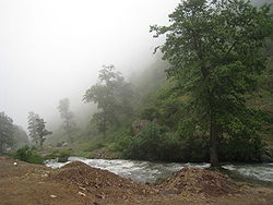
Its attractions include Alamkooh Mountain (the second tallest peak in Iran (4850 m)), Abbasabad Road, Valasht lake and cooler climate. Picnicking and mountain climbing in the area surrounding Rudbarak, Mazandaran, Mazandaran are also popular, as well as in the Abbasabad Forest nearby.[citation needed]
The majority of the inhabitants speak Mazandarani language, but a few migrants speak Kurdish.[6]
See also[]
- Kelar Mound, Neolithic dwelling site in Kelardasht
- Rudbarak, Mazandaran, Roudbarak located North of Kelardasht
- , Mazichal Village in Kelardasht . Mazichal is the forest village which is located in the North of Iran in Kelardasht Province and is known for its Cloud Ocean & breathtaking scenes and views. Mazichal in local language means the Forest Pit full of Oak Trees. this area is a popular tourist destination, as it has many areas with unique geological, historic, and cultural features. Mazichal is located 2,600m above sea level
References[]
- ^ https://www.amar.org.ir/english
- ^ Kelardasht can be found at GEOnet Names Server, at this link, by opening the Advanced Search box, entering "-3841000" in the "Unique Feature Id" form, and clicking on "Search Database".
- ^ "Census of the Islamic Republic of Iran, 1385 (2006)" (Excel). Statistical Center of Iran. Archived from the original on 2011-11-11.
- ^ Saeidian, Abdolhossein. Know the Cities of Iran [Persian title is Shenakht-e Sharha-ye Iran]. Alam va Zendagi, Tehran 2000. Second printing 2004. Pages 705-708. [Text is in Persian]
- ^ Pur, Ali Malek. Kelardasht (geography, History & Culture). Tehran: Kar Afrinan, 1999.
- ^ http://www.magiran.com/npview.asp?ID=1535663
External links[]
| Wikimedia Commons has media related to Kelardasht. |
| show |
|---|

| show |
|---|
| show Authority control |
|---|
This Chalus County location article is a stub. You can help Wikipedia by . |
- Cities in Mazandaran Province
- Populated places in Chalus County
- Tourist attractions in Mazandaran Province
- Chalus County geography stubs