Kengcheng
| Kengcheng State | |||||||||||
|---|---|---|---|---|---|---|---|---|---|---|---|
| State of the Shan States | |||||||||||
| 18th century–1896 | |||||||||||
 | |||||||||||
| History | |||||||||||
| History | |||||||||||
• Foundation of the state | 18th century | ||||||||||
• Division of the state | 1896 | ||||||||||
| |||||||||||
Kengcheng or Keng Cheng (also known as Kyaingchaing and Chiang Khaeng) was one of the Shan states. In 1896, part of Keng Cheng was incorporated into the neighbouring state of Kengtung in what is today Burma, and the other part, which is now in Laos, went to French Indochina.[1]
History[]
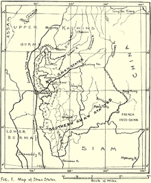
Kengcheng was a tributary state of the King of Burma until 1887, when the Shan states submitted to British rule after the fall of the Konbaung dynasty. The capital of Keng Cheng was at Muang Sing (now part of Laos).[2]
In 1896, Kengcheng was divided between British Burma and French Indochina with the Mekong as a border. The districts of the Cis-Mekong part of the state were merged with Kengtung State and the eastern districts, now the Muang Sing area, went first to Siam and then to the French. The limit between Kengtung and China was demarcated by an Anglo-Chinese commission in 1898–1899.[3]
Sir George Scott mentioned the following about the Keng Cheng Myosa:[4]
This was the unfortunate man who was told that he belonged to Siam and then that he didn't. Half his territory finally handed over to France.
Rulers[]
The rulers of Kengcheng had the title Ngwegunhmu and by c. 1880, it changed to Myoza.[5]
| Reign | Ruler | Remarks |
|---|---|---|
| ? - 1881 | Sao Kawng Tai | d. 1885 |
| 1881 - 1882 | Sao Hsiri | |
| 1882 - 1892 | Hkun Hsang | b. 1862 - d. 19.. |
References[]
- ^ Scott, James George; Hardiman, John Percy (1901). Gazetteer of Upper Burma and the Shan States. 3. AMS Press. ISBN 978-0-404-16860-5.
- ^ Simms, Sanda (2013-10-11). The Kingdoms of Laos. Routledge. ISBN 978-1-136-86330-1.
- ^ "Edward Vaughan Hyde Kenealy". Encyclopedia Britannica. Retrieved 2020-05-31.
- ^ Scott, James George, Sir. 1934. Scott Collection: Views in Keng Tung and the Wild Wa Country.
- ^ "Shan and Karenni States". World Statesmen.org. Retrieved 2020-05-31.
External links[]
- The Tai Of The Shan State
- Keng Cheng
- The Imperial Gazetteer of India
- "WHKMLA : History of the Shan States". 18 May 2010. Retrieved 21 December 2010.
Coordinates: 21°21′N 100°52′E / 21.350°N 100.867°E

This Burmese history article is a stub. You can help Wikipedia by . |
This Shan State location article is a stub. You can help Wikipedia by . |
- States and territories established in the 18th century
- States and territories disestablished in 1896
- Shan States
- Myanmar history stubs
- Shan State geography stubs