Kent Downs
| Kent Downs | |
|---|---|
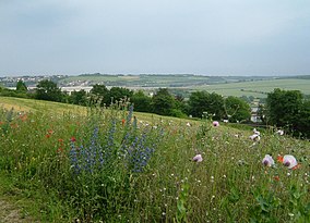 Ranscombe Farm, Medway. In June, these 'unimproved' meadows are covered with chalk grassland flowers. | |
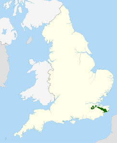 Location of the Kent Downs AONB in the UK | |
| Location | Kent, England |
The Kent Downs is an Area of Outstanding Natural Beauty (AONB) in Kent, England.[1] They are the eastern half of the North Downs and stretch from the London/Surrey borders to the White Cliffs of Dover. The AONB also includes the Greensand Ridge, a prominent sandstone escarpment which lies south of the chalk escarpment of the North Downs.
To the west, Surrey Hills AONB adjoins the Kent Downs AONB.
Areas[]
Among the named parts of the Downs are:
- Alkham Valley – a dry valley north-west of Dover;[2]
- Betsom's Hill – highest point in Kent at 251 metres (823 ft); near Westerham[3][4]
- Blue Bell Hill
- Burham Down
- Castle Hill
- Chartham Downs
- Detling Hill
- Hollingbourne Downs
- Summerhouse Hill
- Tolsford Hill
- Wye Downs
Walking[]
The North Downs Way runs through the full length of the AONB.
References[]
- ^ The Kent Downs website
- ^ *walks/rides available in this Valley Archived 2007-05-02 at archive.today
- ^ Muir, Jonny (2011). The UK's County Tops: Reaching the top of 91 historic counties. Cicerone. p. 32. ISBN 9781849655538.
- ^ Simon Edwardes (2001). "Historic County Tops". The Mountains of England and Wales. Retrieved 20 April 2014.
External links[]
| East of England |  | |
|---|---|---|
| East Midlands | ||
| North East | ||
| North West | ||
| South East | ||
| South West | ||
| West Midlands | ||
| Yorkshire and the Humber | ||
| ||
Coordinates: 51°17′N 0°35′E / 51.29°N 0.58°E

This Kent location article is a stub. You can help Wikipedia by . |
Categories:
- Areas of Outstanding Natural Beauty in England
- Hills of Kent
- Protected areas of Kent
- Chalk landforms
- Kent geography stubs