Kerur, Paschim Medinipur
Kerur | |
|---|---|
Village | |
 Kerur Location in West Bengal, India | |
| Coordinates: 22°11′10″N 87°40′08″E / 22.1862°N 87.6688°ECoordinates: 22°11′10″N 87°40′08″E / 22.1862°N 87.6688°E | |
| Country | |
| State | West Bengal |
| District | Paschim Medinipur |
| Population (2011) | |
| • Total | 1,652 |
| Languages | |
| • Official | Bengali, Santali, English |
| Time zone | UTC+5:30 (IST) |
| PIN | 721155 |
| Telephone/STD code | 03228 |
| Lok Sabha constituency | Ghatal |
| Vidhan Sabha constituency | Sabang |
| Website | paschimmedinipur |


Kerur is a village in the Sabang CD block in the Kharagpur subdivision of the Paschim Medinipur district in the state of West Bengal, India.
Geography[]
CT: census town, R: rural/ urban centre, H: historical/ religious centre
Owing to space constraints in the small map, the actual locations in a larger map may vary slightly
Location[]
Kerur is located at 22°11′10″N 87°40′08″E / 22.1862°N 87.6688°E.
Area overview[]
Kharagpur subdivision, shown partly in the map alongside, mostly has alluvial soils, except in two CD blocks in the west – Kharagpur I and Keshiary, which mostly have lateritic soils. Around 74% of the total cultivated area is cropped more than once.[1] With a density of population of 787 per km2nearly half of the district's population resides in this subdivision. 14.33% of the population lives in urban areas and 86.67% lives in the rural areas.[2]
Note: The map alongside presents some of the notable locations in the subdivision. All places marked in the map are linked in the larger full screen map.
Demographics[]
According to the 2011 Census of India, Kerur had a total population of 1,652, of which 847 (51%) were males and 805 (51%) were females. There were 200 persons in the age range of 0–6 years. The total number of literate persons in Kerur was 1,258 (86.64% of the population over 6 years).[3]
.*For language details see Sabang (community development block)#Language and religion
Education[]
Kerur High School is a Bengali-medium co-educational institution established in 1970. It has facilities for teaching from class V to class X. It has a library with 594 books, 10 computers and a playground.[4]
Kerur picture gallery[]
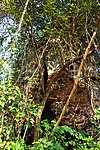
Baikunthanath deul

Baikunthanath deul


References[]
- ^ "District Human Development Report Paschim Medinipur, 2011". page 27-28. Department of Planning and Statistics, Government of West Bengal. Retrieved 10 September 2020.
- ^ "District Statistical Handbook Paschim Medinipur, 2013". Table 2.2, 2.4 (a). Department of Planning and Statistics. Retrieved 10 September 2020.
- ^ "CD block Wise Primary Census Abstract Data(PCA)". West Bengal – District-wise CD blocks. Registrar General and Census, India. Retrieved 19 August 2020.
- ^ "Kerur High School U Pry". Schools.org. Retrieved 19 August 2020.
External links[]
| Wikimedia Commons has media related to Kerur, Sabang CD block. |
Cities, towns and locations in Paschim Medinipur District, Medinipur division | ||||||||
|---|---|---|---|---|---|---|---|---|
| Cities, municipal and census towns |
|  Divisions of West Bengal | ||||||
| Locations other than cities and towns | ||||||||
| Related topics |
| |||||||
This article about a location in the Paschim Medinipur district of West Bengal is a stub. You can help Wikipedia by . |
- Villages in Paschim Medinipur district
- West Bengal geography stubs