Ketch Ranch House (Oklahoma)
| Ketch Ranch House | |
|---|---|
 | |
 Ketch Ranch House Ketch Ranch in Oklahoma | |
| Alternative names |
|
| General information | |
| Type | Bungalow |
| Architectural style |
|
| Location |
|
| Address | Running Deer Camp Road |
| Town or city | Medicine Park, Oklahoma |
| Country | United States of America |
| Coordinates | 34°42′18″N 98°34′22″W / 34.7048714°N 98.5728528°WCoordinates: 34°42′18″N 98°34′22″W / 34.7048714°N 98.5728528°W |
| Groundbreaking | May 1923 |
| Completed | 1924 |
| Cost | $4500.00 |
| Owner |
|
| Height | |
| Roof | Shingle |
| Technical details | |
| Material | Cobblestone |
| Floor count | One |
| Floor area | 2,146 square feet (199.4 m2) |
| Grounds | 5,145 acres (2,082 ha) |
| Known for | Cobblestone architecture |
| Other information | |
| Number of rooms | Six |


Ketch Ranch House or Ketch Ranch was private property located in the Wichita Mountains of Southwestern Oklahoma.[1][2] The ranch was established as a working ranch and vacation home for Ada May Ketch and Frank Levant Ketch during the early 1920s. The Wichita Mountain ranch offered a guest house, barn, smokehouse, springhouse, and root cellar while providing outdoor experiences with horseback riding, boating, and fishing at Ketch Lake which was close proximity of 1 mile (1.6 km) from the Ketch Ranch House.[3][4]
Ada May Ketch purchased the Wichita Mountain acreage on May 8, 1923, from S.P. Thornhill through the property holdings of First National Bank of Lawton. The Ketch Ranch was developed during the economic prosperity years of the Roaring Twenties which simultaneously encompassed the creation of Oklahoma Senator Elmer Thomas's River Rock Resort better known as Medicine Park, Oklahoma.[5]
By 1932, the Ketch Ranch estate began to acknowledge the financial crisis coerced by the Wall Street Crash of 1929. In 1934, the estate was sold on a joint extension agreement to the Monte Vista Ranch enterprise whereas the Ketch family retained the Wichita Mountain ranch. On January 10, 1941, the United States government acquired the Monte Vista Ranch property through the provisions of Declaration of Taking Act authorizing a land expansion of the Fort Sill Military Reservation while protecting the United States national security at the commencement of World War II.
Case Law and Jake L. Hamon, Sr. Estate[]
Frank Ketch served as the business enterprise administrator for the Jake L. Hamon Sr. estate.[6][7][8] Mr. Hamon governed holdings and ownership of capitalist properties in the crude oil fields of Healdton, Oklahoma, Hewitt, Oklahoma, and Stephens County, North Texas exemplary of the 1920s economic opportunism and interwar period.[9][10][11][12]
Court Cases of Jake L. Hamon, Sr. Estate
- Text of Hamon v. State, 67 Okla. 128, (Supreme Court of Oklahoma 1917) is available from: Justia
- Text of Hamon v. Keyes, 99 Okla. 19, (Supreme Court of Oklahoma 1924) is available from: Justia
- Text of Ketch v. Weaver Bros, 261 S.W. 380, (Texas Appeals 1924) is available from: CourtListener Casetext Casemine
- Text of Ketch v. Cox, 105 Okla. 283, (Supreme Court of Oklahoma 1925) is available from: CourtListener Justia Casemine
- Text of Apple v. Given, 117 Okla. 79, (Supreme Court of Oklahoma 1925) is available from: CourtListener Justia Casemine
- Text of Apple v. Hert, 122 Okla. 153, (Supreme Court of Oklahoma 1927) is available from: Justia
- Text of Apple v. McCain, 127 Okla. 147, (Supreme Court of Oklahoma 1927) is available from: Justia
- Text of Ketch v. Smith, 131 Okla. 263, (Supreme Court of Oklahoma 1928) is available from: Justia
Pictorial Biography[]
- Ketch Ranch House ~ Fort Sill Military Reservation

Cobblestone columns at driveway entrance
Cobblestone retaining wall at driveway entrance
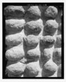
Cobblestone architecture detail of Ketch Ranch House

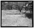
Ketch Ranch House exterior structure near Medicine Park
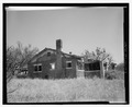
Ketch Ranch House exterior structure near Medicine Park

Ketch Ranch House exterior structure near Medicine Park
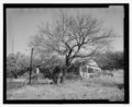
Ketch Ranch House exterior structure near Medicine Park
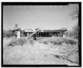
Ketch Ranch House exterior structure near Medicine Park
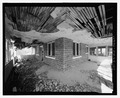
Ketch Ranch House exterior of front porch structure
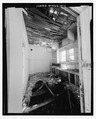
Ketch Ranch House interior of kitchen area

Ketch Ranch House interior of bedroom area


Native American Culture of Wichita Mountains[]
The Ketch Ranch estate was established approximately 4 miles (6.4 km) to 6 miles (9.7 km) northeast of Craterville Park, Oklahoma.[13][14] Craterville Park was established after the Kiowa-Comanche-Apache land openings coinciding with the turn of the 20th century being 1901 to 1907 as Oklahoma became the 46th state to enter the federal republic on November 16, 1907.[15][16][17]

In 1924, the Apache, Comanche, and Kiowa tribes pledged the Craterville Park Covenant with Comanche County rancher Frank Rush.[18][19] The Wichita Mountains mixed grass prairie served for the local tribal pow wow events during the Craterville Park Indian Fair from 1924 to 1933.[20][21]
The Craterville Park Covenant
The object of this Fair will be to create self-confidence and to encourage leadership by the Indian for his people, to better his position, and to take his place on terms of equality with other races in the competitive pursuits of every day life, and a desire to accomplish the most possible for himself and his people.[22][23]
May 25, 1924
The Quanah Parker Star House was located south of the Quanah Mountain summit and west of Craterville Park on Oklahoma State Highway 115 approximately 2 miles (3.2 km) north of Cache, Oklahoma or U.S. Route 62 in Oklahoma.[24][25][26] The Native American immeasurable presence cultivated a historical perspective for the last of the 19th century American Indian tribal chiefs adapting the ceremonial practices of the Native American Church while residing in the Great Plains of Southwestern Oklahoma and the Wichita Mountains.[27][28][29]
See also[]
- Causes of the Great Depression
- Depression of 1920-21
- Dust Bowl
- Fort Sill
- Indian Appropriations Act
- Wichita Mountains Wildlife Refuge
Historical Perspective for Exploration of Oil
Historical Video Archive
- The Century: America's Time – American Broadcasting Company playlist on YouTube
- The Prize: The Epic Quest for Oil, Money & Power – Daniel Yergin playlist on YouTube
References[]
- ^ U.S. Geological Survey Geographic Names Information System: Ketch Ranch
- ^ United States Geological Survey. Mount Scott, OK quadrangle, Ketch Ranch House (Topographic map). Reston, VA: United States Geological Survey – via TopoQuest.
- ^ U.S. Geological Survey Geographic Names Information System: Ketch Lake
- ^ United States Geological Survey. Mount Scott, OK quadrangle, Ketch Lake (Topographic map). Reston, VA: United States Geological Survey – via TopoQuest.
- ^ Lott, David C. (June 14, 2010). Medicine Park: Oklahoma's First Resort. Images of America. Arcadia Publishing. pp. 47–78. ISBN 978-0738577456. OCLC 646185401.
- ^ "Hamon's Estate Appraised at $3,143,903". National Petroleum News. Cleveland, Ohio: National Petroleum Publishing Company. XIII (1): 46. February 16, 1921.
- ^ "Hamon, Jake L., Ardmore, Okla" [International Petroleum Register; A Yearly Directory of the Active Oil Companies of the World]. HaithTrust. New York City: Oil Trade Journal. 1921. p. 313.
- ^ "Ketch Denies J.B. French Purchased the Hamon Holdings in North Texas". Oil Distribution News. Kansas City, Missouri: Oil and Gas News Publishing Company. IX (21): 3. July 7, 1921.
- ^ "Healdton Field". The Encyclopedia of Oklahoma History and Culture. Oklahoma Historical Society.
- ^ "Hewitt Field". The Encyclopedia of Oklahoma History and Culture. Oklahoma Historical Society.
- ^ "JimKurn – The Newest Town in Texas" [Breckenridge American (Breckenridge, Tex), Vol. 1, No. 82, Ed. 1]. The Portal to Texas History. University of North Texas. October 2, 1920.
- ^ "Ranger, Desdemona, and Breckenridge Oilfields". Handbook of Texas Online. Texas State Historical Association.
- ^ U.S. Geological Survey Geographic Names Information System: Craterville Park
- ^ United States Geological Survey. Mount Scott, OK quadrangle, Craterville Park, Oklahoma (Topographic map). Reston, VA: United States Geological Survey – via TopoQuest.
- ^ "Kiowa-Comanche-Apache Opening". The Encyclopedia of Oklahoma History and Culture. Oklahoma Historical Society.
- ^ "Delegation of Comanche. Kiowa, and Apache, including Quanah Parker". Tulsa, Oklahoma: Gilcrease Museum.
- ^ "Kiowa and Comanche Documents". Tulsa, Oklahoma: Gilcrease Museum.
- ^ "The Craterville Park Covenant". Tulsa, Oklahoma: Gilcrease Museum.
- ^ "Chief Brave Bear and Frank Rush of Craterville Park, Oklahoma". Tulsa, Oklahoma: Gilcrease Museum.
- ^ "Craterville Park Indian Fair". The Encyclopedia of Oklahoma History and Culture. Oklahoma Historical Society.
- ^ "Pow Wows". The Encyclopedia of Oklahoma History and Culture. Oklahoma Historical Society.
- ^ "The Craterville Park Covenant". Lawton, Oklahoma: Museum of the Great Plains. Southwest Wilds & Waters. 1924.
- ^ "Craterville Park Pictorial Biography". Frank Rush Collection ~ Western History Collections. University of Oklahoma.
- ^ "Home of Quanah Parker in the Wichita Mountain, The Comanche White House". Tulsa, Oklahoma: Gilcrease Museum.
- ^ "Home of Quanah Parker near Cache, Okla". Arthur R. Lawrence Collection. Lawton, Oklahoma: Museum of the Great Plains.
- ^ United States Geological Survey. Quanah Mountain, OK quadrangle, Quanah Mountain Summit (Topographic map). Reston, VA: United States Geological Survey – via TopoQuest.
- ^ "Native American Church". The Encyclopedia of Oklahoma History and Culture. Oklahoma Historical Society.
- ^ "Indian Religion". Tulsa, Oklahoma: Gilcrease Museum.
- ^ "Peyote Ceremony". Tulsa, Oklahoma: Gilcrease Museum.
Periodical Bibliography[]
- "Says Jake Hamon Told Woman to Flee; Clara Smith's Attorneys Assert She First Heard of Death at El Paso". The New York Times. December 25, 1920.
- "Court Recessed at Noon; Mrs. Jake Hamon to Testify". United States Library of Congress. The Daily Ardmoreite. March 13, 1921.
- "Mrs. Hamon and Ketch on Stand in Murder Case". United States Library of Congress. Grand Forks Herald. March 14, 1921.
- "Ketch Declares Hamon Wanted Clara to Leave" [Business Manager of Hamon Interests Relates Conversations]. The Portal to Texas History. Brownwood Bulletin. March 14, 1921.
- "State to Rest Its Case Today". United States Library of Congress. The Morning Tulsa Daily World. March 14, 1921.
- "Hamon's Widow Testifies at Trial". The New York Times. March 15, 1921.
Petroleum Industry Bibliography[]
- "Jake Hamon, Oil Man of Oklahoma, Is Shot". National Petroleum News. Cleveland, Ohio: National Petroleum Publishing Company. XII (47): 32. November 24, 1920.
- "Gunshot Wound Proves Fatal to Jake Hamon". National Petroleum News. Cleveland, Ohio: National Petroleum Publishing Company. XII (48): 36. December 1, 1920.
External links[]
 Media related to Ketch Ranch at Wikimedia Commons
 Medicine Park travel guide from Wikivoyage
- "Ketch Ranch House ~ Fort Sill Military Reservation, Building 7775" [Historic American Buildings Survey ~ HABS No. OK-66] (PDF). Medicine Park, Comanche County, Oklahoma: United States Library of Congress.
- "Ketch Ranch (Fort Sill Military Reservation, Building 7775)" (PDF). HABS No. OK-66. United States Library of Congress.
- "Ketch Ranch House". Photo, Print, Drawing. United States Library of Congress.
- "Ketch Lake Dam at Fort Sill, Oklahoma Project Profile" (PDF). BASF Master Builders Solutions. 2010.
- Anderson, H. Allen. "Wichita Falls, Ranger, and Fort Worth Railroad". Handbook of Texas Online. Texas State Historical Association.
- Anderson, H. Allen. "Wichita Falls and Southern Railroad". Handbook of Texas Online. Texas State Historical Association.
- "Clara Smith Hamon in Fort Worth, Texas; Ms. Hamon Surrendered to Answer Murder Charges". United States Library of Congress. 1920. LCCN 2001695112.
- Buildings and structures in Comanche County, Oklahoma
- Houses in Comanche County, Oklahoma
- Eminent domain