Keung Shan
| Keung Shan | |
|---|---|
| 羗山 | |
 Summit of Keung Shan | |
| Highest point | |
| Elevation | 459 m (1,506 ft) |
| Coordinates | 22°13′55″N 113°52′53″E / 22.2319801°N 113.8812912°ECoordinates: 22°13′55″N 113°52′53″E / 22.2319801°N 113.8812912°E |
| Geography | |
 Keung Shan Location of Keung Shan in Hong Kong | |
| Location | Lantau Island, |

Keung Shan (Chinese: 羗山, literally "Ginger Mountain") is a peak in Hong Kong, on southwestern Lantau Island, with a height of 459 metres (1,506 ft) above sea level.[1]
Geology[]
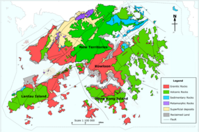
Geological map of Hong Kong showing the distribution of faults and different rock types in Hong Kong. Keung Shan is in the Green area (Volcanic Rock) on Lantau Island
Keung Shan is formed by Volcanic rocks, including porphyritic rhyolites,[2] similar to nearby Lantau Peak and Sunset Peak.
Access[]
The Lantau Trail traverses the summit of this hill.[3]
References[]
- ^ "Node: Keung Shan (1107726531)". OpenStreetMap. Retrieved 2020-06-24.
- ^ "Lantau Volcanic Group (undifferentiated) - Jlu". www.cedd.gov.hk. Retrieved 2020-04-26.
- ^ "Lantau South". www.afcd.gov.hk. Retrieved 2020-06-24.
See also[]
This Hong Kong location article is a stub. You can help Wikipedia by . |
Categories:
- Mountains, peaks and hills of Hong Kong
- Hong Kong geography stubs