Khan Bebin
Khan Bebin
| |
|---|---|
City | |
 | |
 Khan Bebin | |
| Coordinates: 37°02′14″N 55°03′01″E / 37.03722°N 55.05028°ECoordinates: 37°02′14″N 55°03′01″E / 37.03722°N 55.05028°E | |
| Country | |
| Province | Golestan Province |
| County | Ramian |
| Bakhsh | Fenderesk |
| Elevation | 67 m (220 ft) |
| Population (2016 Census) | |
| • Total | 10,878 [1] |
| Time zone | UTC+3:30 (IRST) |
| • Summer (DST) | UTC+4:30 (IRDT) |
| Khan Bebin at GEOnet Names Server | |

Khan Bebin (Persian: خان ببين, also Romanized as Khān Bebīn and Khān Beben, Khān Behbīn, Khanbeh Bon', also known as Khān Bīn)[2] is a city in Fenderesk District, in Ramian County in Golestan Province, in northern Iran. At the 2006 census, its population was 10,435, in 2,561 families.[3]
Centrally located within the Fenderesk District of Golestan Province,[4] Khanbehbin is close to the Shir-Abad Waterfall.
References[]
- ^ https://www.amar.org.ir/english
- ^ Khan Bebin can be found at GEOnet Names Server, at this link, by opening the Advanced Search box, entering "-3070536" in the "Unique Feature Id" form, and clicking on "Search Database".
- ^ "Census of the Islamic Republic of Iran, 1385 (2006)" (Excel). Statistical Center of Iran. Archived from the original on 2011-11-11.
- ^ Rabino, Hyacinth Lois (1928). Mazandaran and Astarabad. London. pp. 82, 128. ISBN 9780700715046.
External links[]
- Khanbehbin entry in the Dehkhoda Dictionary (Persian)
- Khanbehbin map
- Khanbehbin geographical map
| Capital | 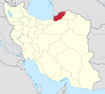 | |
|---|---|---|
| Counties and cities | ||
| Sights |
| |
| populated places | ||
| Capital | |||||||||||||
|---|---|---|---|---|---|---|---|---|---|---|---|---|---|
| Districts |
| ||||||||||||
This Ramian County location article is a stub. You can help Wikipedia by . |
Categories:
- Populated places in Ramian County
- Cities in Golestan Province
- Ramian County geography stubs