Khao Phra Wihan National Park
This article includes a list of general references, but it lacks sufficient corresponding inline citations. (February 2021) |
| Khao Phra Wihan National Park | |
|---|---|
| อุทยานแห่งชาติเขาพระวิหาร | |
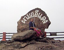
 Mo view from Pha Mo I Daeng Stairway | |
 | |
| Location | Kantharalak District, Thailand |
| Nearest city | Sisaket (town) |
| Coordinates | 14°26′42.25″N 104°43′58.52″E / 14.4450694°N 104.7329222°ECoordinates: 14°26′42.25″N 104°43′58.52″E / 14.4450694°N 104.7329222°E |
| Area | 130 km2 (50 sq mi) |
| Established | 20 March 1998 |
| Visitors | 202,616 (in 2019) |
| Governing body | Department of National Park, Wildlife and Plant Conservation (DNP) |

Khao Phra Wihan National Park (Thai: อุทยานแห่งชาติเขาพระวิหาร) is a protected natural area in Sisaket Province, Thailand, that contains numerous ruins of the 11th century Khmer Empire. The park lies 98 km (61 mi) south of the town of Sisaket, at the end of Thai highway 221. Sited on a red stone cliff that is part of the Dangrek mountain range on the southern edge of the Khorat Plateau, it abuts the international border between Thailand's Sisaket Province and Cambodia's Preah Vihear Province. The name of the cliff in the Royal Thai General System of Transcription is Pha Mo I Daeng (ผามออีแดง). The park was established on 20 March 1998.[1]
Gateway to Prasat Khao Phra Wihan[]

The park atop Pha Mo I Daeng is the Thai gateway to ruins associated with the temple of Prasat Preah Vihear, and is generally open to everyone upon payment of entrance fees. When relations between the two countries are normal, the temple ruins are also accessible from the Thai side. Both sides charge additional entrance fees for such access, but Cambodia does not require visas. Access from the Cambodian side is to the temple ruins only. The International Court of Justice awarded the temple ruins to Cambodia in 1962,[2] but these are located in an area of 4.6 km² that Thailand still claims.[3] Nevertheless, in 2008 the World Heritage Committee's 32nd Session listed the Temple of Preah Vihear as a UNESCO World Heritage Site,[4] which prompted an armed dispute.

For visitors' safety, areas with landmines are clearly marked.
Dispute[]
In 2007, Cambodia proposed to the World Heritage Committee's Thirty-First Session that Preah Vihear Sanctuary be listed as a UNESCO World Heritage Site. As Cambodia and Thailand had not resolved border issues concerning the site, the Committee postponed consideration to its 32nd session, and asked Cambodia to provide a complete management plan for the area. Early in January 2008, Cambodia invited Thai experts to participate in a site survey of the Buffer Zone, and then to Siem Reap and Phnom Penh to collaborate with a team of international experts in the making of a plan for the area in Cambodian territory. Thai experts found "unacceptable scientific inaccuracies" in documents presented, dissociated themselves from the group, and then published in rebuttal their own Management Plan for Preah Vihear Mountain and Its Setting. A PDF English language version of the Plan has been released.[5]
Following a February 2011 request from Cambodia for Thai military forces to be ordered out of the area, judges of the International Court by a vote of 11–5 ordered that both countries immediately withdraw their military forces, and further imposed restrictions on their police forces. The court said its ruling would not prejudice any final ruling on where the border in the area between Thailand and Cambodia should fall. It could take the court many months or even years to reach that decision.[6] Abhisit Vejjajiva (caretaker Prime Minister since the just-concluded 2011 Thai general election) said that Thai soldiers will not pull out from the disputed area until the military of both countries agree on the mutual withdrawal. "[I]t depends on the two sides to come together and talk," he said, suggesting that an existing joint border committee would be the appropriate place to plan a coordinated pullback.[7]
Nomenclature[]
The park takes its name from of Pali-Sanskrit origin.
- Prasat (ปราสาท) is from Sanskrit prāsāda "castle". Thai languages use Prasat to designate ruins resembling forts.
- Phra (พระ) is from Sanskrit varaḥ "excellent."
- Wihan (วิหาร) is from Sanskrit/Pali Vihara "temple" or its central structure.
- Khao (เขา) is Thai for a mount, mountain, or hill ("phnom" in Khmer; Cambodians may say "Phnom Preah Vihear".[8]) เขาวิหาร may be translated into the English language as Temple Hill.[9]
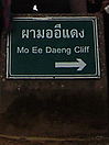
Pha Mo I Daeng[]
- Pha (ผา) is a cliff, crag, rock or tor.[10]
- Mo (มอ) pronounced like English "maw" with an even tone means gray or gloomy.[11] (Royal Institute Dictionary 1982 edition "mo" definition 4: [qualifier] blurred, such as mountains obscured darkly (มอ ๔/มอ/[วิเศษณ์] สีมัว ๆ อย่างสีดำเจือขาว.)
- I (อี) pronounced like English "ee" is a designation for one without customary restraint.[12]
- Daeng (แดง) is red.
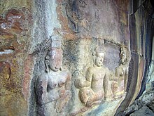
Mo Ee Daeng Cliff rears over 500 metres above the Cambodian plain. In 1987, a Border Protection Ranger Unit discovered two groups of bas-relief images and engravings. The Management Plan says on p. 14, "Based on iconography, the figures are dated circa 10th century, or older than Preah Vihear Temple." The figures are now a highlight of the park. Some parts have flaked off, so the area is barred behind a gate. A staircase leads down to the gate, where the images are clearly visible.
Other sights[]
The park is covered by dry evergreen forest, mixed dipterocarp forest, and deciduous dipterocarp forest with tree species like Pterocarpus macrocarpus, Shorea siamensis and Xylia xylocarpa var. kerrii. It is home to numerous wildlife which roams between two countries such as wild hog, deer, barking deer, rabbit, squirrel, gibbon and civet.

'Twin Stupas. The Twin Stupas are two red sandstone structures, 1.93 m. square and 4.20 m. high, with lotus-bud-shaped apices.
Don Tuan Khmer Ruins. Built during the 10th -11th Century, the Khmer Ruins near Ban Phume Sarol (บ้านภูมิซรอล) are located at 14°24′26″N 104°44′45″E / 14.40722°N 104.74583°E, 350 meters onto the Cambodia side of the distinct watershed border ridge, at an elevation of 250 meters above sea level, 30 meters below and 350 meters southwest of the border ridge. The only road access, however, is from Thailand. Legend tells that in the past a lady known as Nang Nom Yai or Nieng Non dor (in Khmer), stopped to rest here on her way to visit a king.
Namtok and Tham Khun Sri. The three-tiered waterfall, above the cave, is situated west of Sra trao close to trail to Phreah Vihear. Khun Sri Cave is of gigantic proportions and was believed to have been the accommodation of Khun Sri, a noble man who controlled rock cutting at Sra Trao at the time of the construction of Preah Vihear Sanctuary.
Namtok Phu La-Ō (น้ำตกภูละออ). Situated in Phanom Dongrak Wildlife Sanctuary, Tambon Sao Thongchai, the small waterfall turns vibrant during September to February.
See also[]
- Cambodian–Thai border dispute
- Irridentism
- Preah Vihear Temple
Notes[]
- ^ http://www.ratchakitcha.soc.go.th/DATA/PDF/2541/A/014/5.PDF[bare URL PDF]
- ^
"Temple of Preah Vihear (Cambodia v. Thailand)". Summary of the Summary of the Judgment of 15 June 1962. International Court of Justice. Archived from the original (text/html 19.79 KB) on 18 September 2008. Retrieved 25 November 2010.
Judgment of 15 June 1962 :Proceedings in the case concerning the Temple of Preah Vihear, between Cambodia and Thailand, were instituted on 6 October 1959 by an Application of the Government of Cambodia; the Government of Thailand having raised two preliminary objections, the Court, by its Judgment of 26 May 1961, found that it had jurisdiction. :In its Judgment on the merits the Court, by nine votes to three, found that the Temple of Preah Vihear was situated in territory under the sovereignty of Cambodia and, in consequence, that Thailand was under an obligation to withdraw any military or police forces, or other guards or keepers, stationed by her at the Temple, or in its vicinity on Cambodian territory. By seven votes to five, the Court found that Thailand was under an obligation to restore to Cambodia any sculptures, stelae, fragments of monuments, sandstone model and ancient pottery which might, since the date of the occupation of the Temple by Thailand in 1954, have been removed from the Temple or the Temple area by the Thai authorities. :Judge Tanaka and Judge appended to the Judgment a Joint Declaration. Vice-President Alfaro and Judge Sir Gerald Fitzmaurice appended Separate Opinions; Judges , Wellington Koo and Sir Percy Spender appended Dissenting Opinions.
- ^ Bora Touch, Esq. (29 June 2008). "Preah Vihear Temple and the Thai's Misunderstanding of the World Court Judgment of 15 June 1962" (JPEG Image). preah-vihear.com/preahv2.jpg. www.preah-vihear.com. Retrieved 22 November 2010.
(Preah Vihear A Disputed Area))
- ^ "Temple of Preah Vihear". World Heritage Convention. Retrieved 23 November 2010.
Cambodia / N14 23 18 E104 41 2 / Date of Inscription: 2008 / Criteria: (i) / Property : 155 ha / Buffer zone: 2,643 ha / Ref: 1224rev
- ^ "Management Plan for Preah Vihear Mountain and Its Setting" (PDF Version 1.6 (Acrobat 7.x)1.02 MB). File 03MgnPlan Created 7/1/2008 ; modified 7/2/2008. Office of Archaeology (สำนักโบราณคดี), Fine Arts Department (อำมาตยากรมศิลปากร), Ministry of Culture, and ICOMOS Thailand (อืโคโมสไทย) 81/1 Si Ayutthaya Rd., Dusit District, Bangkok 10300, THAILAND. 2008. p. 1. Retrieved 21 November 2010.
From the meeting [11th – 14th, January, 2008 in Siem Reap and Phnom Penh,] it has been discovered that there are unacceptable scientific inaccuracies in the content of the documents, from the Nomination File composed by the Cambodian party to the Conclusion Report composed by international experts. The Thai experts, therefore, declared dissociation from the international experts group and rebutted the scientific information as mentioned.
- ^ "UN orders troops away from temple". The Independent. 18 July 2011. Asia. Retrieved 18 July 2011.
- ^ Arthur Max (18 July 2011). "UN court draws DMZ for Thai, Cambodia troops". The San Francisco Examiner. AP. Retrieved 18 July 2011.[permanent dead link]
- ^ "Prasat Preah Vihear Temple". www.preah-vihear.com. Retrieved 22 November 2010.
- ^ So Sethaputra, สอ เสถบุตร (1999). New Model Thai-English Dictionary. Bangkok: ไทยวัฒนาพานิช : Thai Watthanā Phānit. p. 49. ISBN 974-08-3253-9.
- ^ So, p. 194
- ^ So, p. 222
- ^ So, p. 339
External links[]
 Preah Vihear travel guide from Wikivoyage
![]() Media related to Khao Phra Wihan National Park at Wikimedia Commons
Media related to Khao Phra Wihan National Park at Wikimedia Commons
- IUCN Category II
- National parks of Thailand
- Dângrêk Mountains
- Tourist attractions in Sisaket province
- Protected areas established in 1998
- 1998 establishments in Thailand