Killin
This article needs additional citations for verification. (February 2012) |
Killin
| |
|---|---|
 Main Street, Killin, with Meall nan Tarmachan in the background to the north | |
 Killin Location within the Stirling council area | |
| Population | 666 (2001 Census) |
| OS grid reference | NN572328 |
| Civil parish |
|
| Council area | |
| Lieutenancy area | |
| Country | Scotland |
| Sovereign state | United Kingdom |
| Post town | Killin |
| Postcode district | FK21 |
| Dialling code | 01567 |
| Police | Scotland |
| Fire | Scottish |
| Ambulance | Scottish |
| UK Parliament | |
| Scottish Parliament | |
| Website | /www.killin.info |

Killin (/ˌkɪlˈɪn/; (Scottish Gaelic: Cill Fhinn) is a village situated at the western head of Loch Tay in the central highlands of Scotland. The village is administered by the Stirling council area but is more closely tied to the historic county of Perthshire, Scotland. Killin is a historic conservation village and sits within the Loch Lomond and The Trossachs National Park.It is the central settlement of the historic region of Breadalbane.
Killin is notable as a historically important part of the Gaidhealtachd of Perthshire and a centre of wildlife and adventure tourism.
A recent analysis (July 2021) by a leading mental health life insurance provider identified Killin as the second-best holiday destination for wellness in the United Kingdom [1]
Location and Etymology[]
The west end of the village is magnificently sited around the scenic Falls of Dochart (Scottish Gaelic: Eas Dochard), the main street leading down towards the Loch at the confluence of the rivers Dochart (Scottish Gaelic: Abhainn Dochard) and (Scottish Gaelic: Abhainn Lòchaidh). The falls are crossed by a narrow, multi-arched stone bridge carrying the main A827 road into Killin. The A827 provides road access from the South and West, with travel times from the main Scottish cities of Edinburgh and Glasgow of approximately 90 minutes. The A827 road also provides access from the north and East, albeit via a higher level rural route along the edge of Loch Tay (Scottish Gaelic: Loch Tatha).
Killin is the central settlement of the historic region of Breadalbane. In Gaelic breadalbane is Bràghad Albainn, "the high part, or the upper part of Scotland". This is an apt toponym as the village is surrounded by prominent and striking mountain ranges including Meall nan Tarmachan and the Ben Lawers range, that provide an alpine backdrop to the village.
The name Killin (Cill Fhinn), is Gaelic and reflects the predominant language of the area for most of recorded history. Killin is sometimes translated into English as the "fair or white church" but is sometimes also translated as "Finn's church, or cell". The latter interpretation links to local legend that Fingal, the mythical hero of the Ossian saga, is buried in the hills overlooking the village.
History[]
The history of Killin is ancient and there is plentiful evidence of prehistoric habitation of the area including several iron-age artificial islands or Crannog's along the shores of Loch Tay - a reconstructed example can be seen at the Scottish Crannog Centre. Other evidence of prehistoric habitation include a preserved standing stone circle, the Kinnell Stone Circle, close to the village along with the less well preserved remains of ancient hill forts around the area.
For a period in history Killin was one of the front lines in the wars between the original Picts people of Highland Scotland and the invading Gaels from Ireland, prior to them becoming united under Kenneth MacAlpin.
The MacNab Clan were once dominant here, and have long been associated with Killin. Their ancient burial ground is still on Inchbuie in the River Dochart, just below the falls, and is accessible from the bridge.
Kinnell House was the seat of the MacNabs. A well-preserved prehistoric stone circle (possibly 'restored' to improve its appearance) known as Killin Stone Circle can be seen in the grounds of the house. To the north of the village lie the ruins of the Campbells of Breadalbane stronghold of Finlarig Castle, with its associated chapel. The growing power of the Campbells eventually ousted the MacNabs, who lost Kinnell House to their rivals. In 1694 Sir John Campbell of Glenorchy, 1st Earl of Breadalbane established Killin as a Burgh of barony. In 1949 Kinnell House and its estate returned to the ownership of the Chief of Clan Macnab, but in 1978 death duties forced the then Chief, James Charles Macnab of Macnab, to sell most of the estate.[2]
The Killin incident of 1749 took place in August 1749 in the tumultuous aftermath of the Jacobite rising of 1745.[3][4] Two men who had been plundering at will in full Highland dress after the Dress Act 1746 had made it illegal wear it, had been captured by soldiers of the British Army, but a large mob secured their release.[3][4]
In 1767 the minister of Killin, James Stuart, published the first New Testament in Scottish Gaelic.
By the end of the 18th century there was a local linen industry. Flax was grown locally, spun in small mills and woven into linen by home based weavers. Today, Killin services the local rural community and the growing tourism and leisure industries. In addition to walking on Ben Lawers National Nature Reserve, fishing for trout and salmon there are various watersports available on Loch Tay. Many local vernacular buildings have been preserved or converted, allowing the village to retain much of its historic character.
The 19th century Moirlanich Longhouse in nearby Glen Lochay is a rare surviving example of the cruck frame Scottish longhouse, and is now in the care of the National Trust for Scotland. The former Breadalbane Folklore Centre in the Victorian mill by the falls displays the 'healing stones' of Saint Fillan.
Tomnadashan Mine, an abandoned copper mine overlooking the village is sometimes identified as the haunt of the Rabbit of Caerbannog of Monty Python and the Holy Grail fame. Nearby Glen Lochay is the location to which Richard Hannay, played by Robert Donat, heads in the 1935 Alfred Hitchcock's film The 39 Steps.
Killin railway station was on the Killin Railway. The railway station was officially closed on 1 November 1965.
Gaelic in Killin[]
Killin has been a strongly Gaelic-speaking village for most of recorded history. It has an important role in the Gaidhealtachd of Perthshire, having always held the largest proportion of Gaelic-speakers in West Perthshire. As a result, it has a rich tradition of Gaelic song and folklore connected to it.
The Gaelic Local Studies summary for Perthshire and Stirling provides an insight into the place of Gaelic in Killin over more than a century:[5]
In 1881 Killin village and rural Killin recorded speakers numbers of 340 (71.9%) and 422 (80.1%) respectively, when Gaelic language ability was included in Scotland's census for the first time. The broader parish of Killin recorded over 1,100 Gaelic speakers living locally at this time, representing 78.5% of the total area population, 5.05% of which (56) where monolingual Gaels. By 1901 this had decreased to 62.5% for rural Killin, 49.3% for the Killin village, and 48% for the broader parish.
Consistent with other parts of Gaelic-speaking Scotland there has been a pattern of gradual language shift away from Gaelic towards English. Despite this it was still common to hear native Perthshire Gaelic in the community in and around Killin in the 1960s and 70s. Indeed, the 1961 census recorded 138 speakers in Killin along with the last recorded monolingual speaker. In the 1971 census there were 120 Gaelic speakers but none of these were monolingual. By the time of the 2001 census the electoral division of Killin recorded only 63 Gaelic speakers (4.7% of the local population) with 39 (5.9%) in Killin village. Despite this decline Killin still recorded the highest numbers of Gaelic speakers in all of West-Perthshire.
Although the Perthshire dialect of Gaelic is considered to be effectively extinct, surviving elderly speakers have recently been identified. However, with a lack of community transmission any surviving speakers in the Killin area are likely to be the final generation of native Perthshire Gaelic speakers.
The decline of Gaelic in the area is in keeping with the trend across Scotland and can be attributed to a combination of events including the Highland clearances (Gaelic: Fuadaichean nan Gàidheal) which resulted in great swathes of locals being forcibly removed from the land. The Education (Scotland) Act 1872 also made it illegal for Gaels to be educated or use their language in formal education settings. These changes along with others have led to a process of language shift across the Highlands and Islands of Scotland.
More recently, Killin has suffered particularly from a lack of Gaelic Medium Education provision from Stirling council. This is in contrast to the provision in neighbouring Perth and Kinross Council, such as the weekly Gaelic lessons at Glen Lyon primary school, close to Killin, and full GME at Breadalbane Academy in nearby Aberfledy. The closest GME provision offered by Stirling council is at Riverside Primary School in Stirling.
Despite its many challenges Gaelic survives in the area amongst a small number of local speakers as well as in the language, history, folklore and many places names of the area.
Amenities[]
Killin is a popular tourist destination and a thriving community with a host of local groups including a drama group, badminton club and youth group. The village is also host to number of practical amenities for locals and visitors.
The Killin News is a free community newspaper issued every 2 months and available by subscription or to be found in local shops and businesses. Further information can be found on their website: wwww.killinnews.co.uk
There are several hotels and more traditional Inns with restaurants catering to locals and hotel residents. The village is also well equipped with several cafes, a post office and chemist, and several small shops including two gift shops, and an outdoor centre (where outdoor equipment can be hired), as well as a small but well stocked Co-op food store.
There is a Petrol station available at Lix Toll, at the junction between the main A85 road and the A827 which leads into Killin.
There is a well-equipped Children's play park in Breadalbane Park in the centre of the village.
Killin has a small primary school with 56 pupils. For secondary education pupils travel to Callander 21 miles (34 km) to the south. Killin has for generations been an important part of the Gàidhealtachd. However, while Gaelic is taught in the primary school, the nearest Gaelic medium primaries are in Stirling, 37 miles (60 km) to the south and Aberfeldy 23 miles (37 km) to the East.
Sights and Activities[]
Killin serves as an excellent base for exploration of both the highlands and central Scotland. Common day trips to the likes of Oban and Glencoe in the Highlands, the market towns of Aberfeldy and Crieff, as well as the lowland urban centres of Glasgow, Stirling, Perth, Dundee and Edinburgh are all easily offered.
In the immediate area there is a great deal to explore, particularly for outdoor enthusiasts.
- Killin is a common base for hillwalkers given its central location and close proximity to several Munroes including the ranges of Meall nan Tarmachan and Ben Lawers.
- Ski touring is a popular activity in the mountains of the area and Killin is only approximately 40 minutes drive to Glencoe Ski area containing good skiing for beginners alongside Scotland's longest and steepest runs.
- The driving route, a long-distance driving route through Perthshire similar to the North Coast 500 passes through the village.
- Ben Lawers National Nature Reserve hosts internationally important examples of alpine plant life.
- The Scottish Crannog Centre museum hosts a reconstructed crannog on Lochtayside, giving insight into the lives of prehistoric peoples of the area.
- Kinnell Stone Circle stand in the grounds of Linnell House in Killin.
- The Falls of Dochart, a beautiful set of rapids on the River Dochart, are the centre point of the village.
- The Clan Macnab Burial ground on Innis Buidhe
- The Moirlanich Longhouse Museum in Killin offers visitors an insight into highland life of the past in a preserved Longhouse.
- Glen Lyon sits immediately above the village in the Loch Rannoch and Glen Lyon National Scenic Area.
- Wildlife tourism is popular in the area, with local species including red squirrels, pine Martin, otters, beavers, osprey and even populations of Scottish Wildcat. Wildlife tours are offered in nearby Dull by Highland Safaris.
- Killin Golf Club offer a picturesque 9-hole Course.
- The Rob Roy Way, a 127 km long-distance walking path runs through Killin.
- National Cycle Route 7 runs through the village.
Events[]
The village has a thriving local community and hosts a number of annual events. These include:
- in August of each year. A traditional highland event incorporating traditional competitions for music, dance, strength and athleticism. More information can be found on the Killin Highland Games website.
- The Killin Music Festival in June of each year. A successful annual music festival with a folk and Gaelic musical focus. The festival was relaunched in 2016 by a local voluntary team.[6]
- Killin 10K and 5K in September of each year.
- Killin Agricultural Show in August each year. Traditionally locals celebrate this event with each house competing to create the best scarecrow in their garden.
- Swim Loch Tay. A competivitive swimming events held in Loch Tay in September of each year.
- Hogmanay Fireworks display. A fireworks (historically this would have been a fire ceremony) display is held to mark the arrival of the new year.
Notable people[]
- Rev Prof Patrick Campbell MacDougall FRSE (1806-1867), Professor of Moral Philosophy at the University of Edinburgh, born in the manse in Killin the son of Rev Hugh MacDougall[7]
- James Stuart (1701-1709) was Minister of Killin and published the first edition of the New Testament in Scottish Gaelic. A prominent monument, written in Gaelic, stands in his memory outside the local Parish Church in front of the Killin Hotel.[8]
Gallery[]

Loch Tay, Killin with Ben Lawers on the left taken from a short distance up Sron a Chlachain.
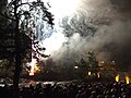
Hogmanay fireworks celebrations on the Bridge of Dochart, Killin.

Breadalbane Visitor Centre, now Killin Water Mill, looking south east across the Falls of Dochart.
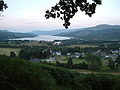
Killin and Loch Tay from the sides of Sron a Chlachain.
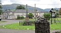
The Stewart Memorial[9] with the McLaren Hall in the background.
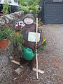
One of many scarecrows in the main street in Killin which are part of the annual Agricultural Festival.
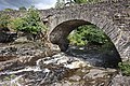
Falls of Dochart with the bridge.

Finlarig Castle in Killin.


References[]
- ^ https://www.scotsman.com/lifestyle/homes-and-gardens/area-focus-killin-3316423. Missing or empty
|title=(help) - ^ Know Your Chief Archived 2012-02-25 at the Wayback Machine at macnabclanuk.org, accessed 25 February 2012
- ^ Jump up to: a b Harris, Robert (2002). Politics and the Nation: Britain in the Mid-Eighteenth Century. Oxford University Press. p. 177. ISBN 9780191554384.
- ^ Jump up to: a b Cunningham, A. D (1994). "A History of Rannoch, After the '45". Electric Scotland. Electric Scotland. Retrieved 8 September 2018.
- ^ (PDF) http://www.linguae-celticae.org/dateien/Gaidhlig_Local_Studies_Vol_27_Peairt_Sruighlea_Ed_II.pdf. Missing or empty
|title=(help) - ^ "New Killin music festival for 2016?". Retrieved 29 September 2015.
- ^ "Prof. Patrick Campbell MacDougall d. Yes, date unknown: MacFarlane Clan & Families Genealogy". www.clanmacfarlanegenealogy.info. Retrieved 5 January 2018.
- ^ http://www.ceuig.co.uk/history/church-and-school/the-gaelic-scriptures/. Missing or empty
|title=(help) - ^ MacKenzie, Gregor. "Stewart Memorial". Killin.info. Retrieved 23 June 2020.
External links[]
| Wikimedia Commons has media related to Killin. |
- Killin.info community website, guides, photos, media, news.
- Killin - A Village History
- Killin on the Gazetteer for Scotland
| show Authority control |
|---|
- Villages in Stirling (council area)