Kirchhaslach
Kirchhaslach | |
|---|---|
 Coat of arms | |
show Location of Kirchhaslach within Unterallgäu district | |
 Kirchhaslach | |
| Coordinates: 48°9′N 10°18′E / 48.150°N 10.300°ECoordinates: 48°9′N 10°18′E / 48.150°N 10.300°E | |
| Country | Germany |
| State | Bavaria |
| Admin. region | Schwaben |
| District | Unterallgäu |
| Municipal assoc. | Babenhausen |
| Government | |
| • Mayor (2020–26) | Franz Grauer jun.[1] |
| Area | |
| • Total | 32.04 km2 (12.37 sq mi) |
| Elevation | 550 m (1,800 ft) |
| Population (2020-12-31)[2] | |
| • Total | 1,315 |
| • Density | 41/km2 (110/sq mi) |
| Time zone | UTC+01:00 (CET) |
| • Summer (DST) | UTC+02:00 (CEST) |
| Postal codes | 87755 |
| Dialling codes | 08333 |
| Vehicle registration | MN |
| Website | www.babenhausen-schwaben.de |


Kirchhaslach is a municipality in the district of Unterallgäu in Bavaria, Germany. The town has a municipal association with Babenhausen, Bavaria.
Buildings[]
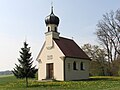
Fugger-Chapel, view from Northeast
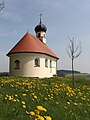
Fugger-Chapel, view from Southwest

Fugger-Chapel inside

Parish church Kirchhaslach, high altar
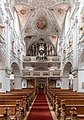
Parish church Kirchhaslach, nave and view of the organ pipe
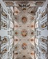
Parish church Kirchhaslach, ceiling


References[]
- ^ Liste der ersten Bürgermeister/Oberbürgermeister in kreisangehörigen Gemeinden, Bayerisches Landesamt für Statistik, 15 July 2021.
- ^ "Tabellenblatt "Daten 2", Statistischer Bericht A1200C 202041 Einwohnerzahlen der Gemeinden, Kreise und Regierungsbezirke". Bayerisches Landesamt für Statistik (in German). June 2021.
| show Towns and municipalities in Unterallgäu |
|---|
| Authority control |
|---|
This Unterallgäu location article is a stub. You can help Wikipedia by . |
Categories:
- Municipalities in Bavaria
- Unterallgäu
- Swabia (Bavaria) geography stubs