Ottobeuren
Ottobeuren | |
|---|---|
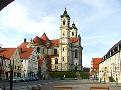 Basilica and market square in Ottobeuren | |
 Coat of arms | |
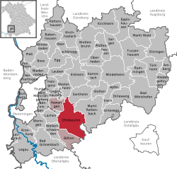
show Location of Ottobeuren within Unterallgäu district | |
 Ottobeuren | |
| Coordinates: 47°56′29″N 10°17′58″E / 47.94139°N 10.29944°ECoordinates: 47°56′29″N 10°17′58″E / 47.94139°N 10.29944°E | |
| Country | Germany |
| State | Bavaria |
| Admin. region | Schwaben |
| District | Unterallgäu |
| Municipal assoc. | Ottobeuren |
| Government | |
| • Mayor (2020–26) | German Fries[1] (FW) |
| Area | |
| • Total | 55.85 km2 (21.56 sq mi) |
| Elevation | 669 m (2,195 ft) |
| Population (2020-12-31)[2] | |
| • Total | 8,498 |
| • Density | 150/km2 (390/sq mi) |
| Time zone | UTC+01:00 (CET) |
| • Summer (DST) | UTC+02:00 (CEST) |
| Postal codes | 87724 |
| Dialling codes | 08332 |
| Vehicle registration | MN |
| Website | www.ottobeuren.de |


Ottobeuren (Swabian: Ottobeire, Medieval Latin: Ottobura)[3] is a market town and municipality in Bavaria, Germany, located 11 km southeast of Memmingen near the A7. It is famous for Ottobeuren Abbey, situated next to the Basilica. The town is seat of a municipal association with Hawangen and Böhen.
The musicologist Manfred Hermann Schmid was born in Ottobeuren.
Twin towns — sister cities[]
Ottobeuren is twinned with:
 Norcia, Italy
 Saint-Donat-sur-l'Herbasse, France
 Tenterfield, New South Wales, Australia
References[]
- ^ Liste der ersten Bürgermeister/Oberbürgermeister in kreisangehörigen Gemeinden, Bayerisches Landesamt für Statistik, 15 July 2021.
- ^ "Tabellenblatt "Daten 2", Statistischer Bericht A1200C 202041 Einwohnerzahlen der Gemeinden, Kreise und Regierungsbezirke". Bayerisches Landesamt für Statistik (in German). June 2021.
- ^ Ott, Michael (1913). . In Herbermann, Charles (ed.). Catholic Encyclopedia. New York: Robert Appleton Company.
| show Towns and municipalities in Unterallgäu |
|---|
| show Authority control |
|---|
This Unterallgäu location article is a stub. You can help Wikipedia by . |
Categories:
- Municipalities in Bavaria
- Unterallgäu
- Swabia (Bavaria) geography stubs