Kirkland, Lancashire
This article needs additional citations for verification. (April 2008) |
| Kirkland | |
|---|---|
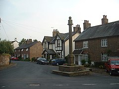 The 18th-century dial post, Churchtown | |
 Kirkland Shown within Wyre Borough | |
| Population | 314 (2011 Census) |
| OS grid reference | SD479438 |
| Civil parish |
|
| District | |
| Shire county | |
| Region | |
| Country | England |
| Sovereign state | United Kingdom |
| Post town | PRESTON |
| Postcode district | PR3 |
| Dialling code | 01995 |
| Police | Lancashire |
| Fire | Lancashire |
| Ambulance | North West |
| UK Parliament | |


Kirkland is a civil parish, located on the banks of the River Wyre, midway between Preston and Lancaster, in the English county of Lancashire. It is also the historic name of what is now the village of Churchtown, within the parish. It is part of the Wyre district. In 2001 the parish had a population of 343,[1] decreasing to 314 at the 2011 census.[2]
Kirkland has a long history centred on its Grade I listed building, St Helen's, the parish church of Garstang St Helen (or Churchtown) and once known as the Cathedral of the Fylde. The church features:
- a "lepers' window" or "squint" to enable those unfortunates an opportunity to attend its services;
- a grave marker for the village's only victim of the Black Plague;
- a large rafter, once known as the "new beam", supposedly presented to the parish by King Henry VIII at the time of the Reformation.
There are significant pointers such as a circular churchyard with several yew trees to its original use as a Druid temple. It was believed by some that the area may have been the site where Christian missionaries from Ireland first set foot in Lancashire at the end of the navigational portion of the River Wyre which flows to the Irish Sea some 14 miles away. St Helen's is one of only two Grade I listed buildings in the Borough of Wyre.[3]
Although known as "The Cross", the village has an 18th-century Grade II listed dialpost with a sundial at its head, at the top of Church Street. There are two pubs: the Punchbowl and the Horns Inn.
Kirkland was once a township in the ancient parish of Garstang. This became a civil parish in 1866, forming part of the Garstang Rural District from 1894 till 1974.[4] It has since become part of the Borough of Wyre.
Along with Great Eccleston, Out Rawcliffe, Inskip-with-Sowerby and Upper Rawcliffe-with-Tarnacre, Kirkland forms part of the Great Eccleston ward of Wyre Borough Council.[5][6]
See also[]
References[]
- ^ "Parish headcount" (PDF). Archived from the original (PDF) on 10 December 2006. Retrieved 13 April 2008.
- ^ UK Census (2011). "Local Area Report – Kirkland Parish (E04005331)". Nomis. Office for National Statistics. Retrieved 27 March 2021.
- ^ "Listed Buildings". Wyre Borough Council. Archived from the original on 27 September 2011. Retrieved 5 June 2015.
- ^ "Kirkland Tn/CP through time". visionofbritain.org.uk. GB Historical GIS / University of Portsmouth. Retrieved 5 January 2022.
- ^ "Great Eccleston". MARIO. Lancashire County Council. Retrieved 5 January 2022.
- ^ "Great Eccleston". Ordnance Survey Linked Data Platform. Ordnance Survey. Retrieved 5 January 2022.
External links[]
| Wikimedia Commons has media related to Kirkland, Lancashire. |
- Map sources for Kirkland, Lancashire - using the name Churchtown
- Lancashire Churches
- Lancashire parish portal
- A History of the County of Lancaster: Volume 7 Pages: 313-15
- A History of the County of Lancaster: St Helen's Church, Kirkland
- Civil parishes in Lancashire
- Geography of the Borough of Wyre
- The Fylde