Kiso Mountains
| Kiso Mountains | |
|---|---|
| Central Alps | |
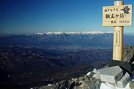 Kiso Mountains from Mount Senjō in the Akaishi Mountains | |
| Highest point | |
| Peak | Mount Kisokoma, Kiso District, Nagano Prefecture |
| Elevation | 2,956 m (9,698 ft) |
| Coordinates | 35°47′22″N 137°48′16″E / 35.78944°N 137.80444°ECoordinates: 35°47′22″N 137°48′16″E / 35.78944°N 137.80444°E |
| Dimensions | |
| Length | 65 km (40 mi) |
| Width | 15 km (9.3 mi) |
| Naming | |
| Native name | 木曽山脈, 中央アルプス (Japanese) |
| Geography | |
| Country | Japan |
| Prefectures | Gifu and Nagano |

Kiso Mountains (木曽山脈, Kiso Sanmyaku) are a mountain range in Nagano and Gifu prefectures in Japan. They are also called the Central Alps (中央アルプス, Chūō Arupusu) and they combine with the Hida Mountains ("Northern Alps") and the Akaishi Mountains ("Southern Alps") to form a group collectively known as the Japanese Alps.
Outline[]
The mountain range consists of granite. The Komagatake Ropeway is on the east side of Mount Kisokoma.[1] A lot of tourists visit the station on the top. The upper part of the mountain range is the tree line, and a lot of alpine plants grow naturally. Leontopodium shinanense of Leontopodium is endemic around Mount Kisokoma.
Geography[]
Major peaks[]
| No. |
Image |
Mountain |
Height |
Note |
Japanese |
|---|---|---|---|---|---|
| 1 | 2,296.25 m (7,534 ft) | 200 famous | 経ヶ岳 | ||
| 2 | 2,730 m (8,957 ft) | 将棊頭山 | |||
| 3 | Mount Kisokoma | 2,955.95 m (9,698 ft) | highest in Kiso Mountains 100 famous |
木曽駒ヶ岳 | |
| 4 | Mount Hōken | 2,931 m (9,616 ft) | Senjōjiki Cirque | 宝剣岳 | |
| 5 | Mount Sannosawa | 2,848.48 m (9,345 ft) | 三ノ沢岳 | ||
| 6 | 2,827.74 m (9,277 ft) | 檜尾岳 | |||
| 7 | 2,778 m (9,114 ft) | 熊沢岳 | |||
| 8 | Mount Utsugi | 2,863.71 m (9,395 ft) | 100 famous | 空木岳 | |
| 9 | Mount Minamikoma | 2,841 m (9,321 ft) | 200 famous | 南駒ヶ岳 | |
| 10 | 2,613.24 m (8,574 ft) | 300 famous | 越百山 | ||
| 11 | 2,303 m (7,556 ft) | 奥念丈岳 | |||
| 12 | 2,363.14 m (7,753 ft) | 200 famous | 安平路山 | ||
| 13 | 2,168.52 m (7,115 ft) | 摺古木山 | |||
| 14 | Mount Ena | 2,191 m (7,188 ft) | 100 famous[2] | 恵那山 | |
| 15 | 1,907.74 m (6,259 ft) | 大川入山 |
- Foothills
- (念丈岳), 2,291 m (7,516 ft)
- (南木曽岳), 1,677 m (5,502 ft)
- Mount Kazakoshi (Kiso) (風越山), 1,699 m (5,574 ft)
- Mount Kazakoshi (Ena) (風越山), 1,535 m (5,036 ft)
Rivers[]
Rivers with headwaters in the Kiso Mountains drain to Ise Bay of the Pacific Ocean. They include:
- Scenery of Kiso Mountains
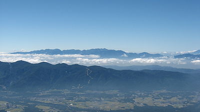
Kiso Mountains seen from east (Mount Amida)

Kiso Mountains seen from west (Mount Kohide)
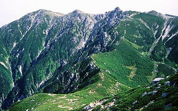
Mt. Kisokoma and Mt. Hōken seen from Mount Sannosawa

Mt. Kisokoma and Mt. Hōken seen from Mount Kazakoshi


See also[]
- Japanese Alps
- Hida Mountains (Northern Alps)
- Akaishi Mountains (Southern Alps)
- List of mountains in Japan
References[]
- ^ "Central Alps Komagatake Ropeway & Bus Services". Chuo Alps Kanko. Archived from the original on 2010-10-16. Retrieved 2011-04-23.
- ^ Mount Ena Outdoor Information. (in Japanese) Take-net. Accessed June 27, 2008.
External links[]
| Wikivoyage has a travel guide for Chuo Alps. |
![]() Media related to Kiso Mountains at Wikimedia Commons
Media related to Kiso Mountains at Wikimedia Commons
This Nagano Prefecture location article is a stub. You can help Wikipedia by . |
This Gifu Prefecture location article is a stub. You can help Wikipedia by . |
- Kiso Mountains
- Japan Alps
- Mountain ranges of Gifu Prefecture
- Mountain ranges of Nagano Prefecture
- Nagano geography stubs
- Gifu geography stubs