Kożuchów
Kożuchów | |
|---|---|
 Medieval fortifications | |
 Flag  Coat of arms | |
 Kożuchów | |
| Coordinates: 51°45′N 15°36′E / 51.750°N 15.600°ECoordinates: 51°45′N 15°36′E / 51.750°N 15.600°E | |
| Country | |
| Voivodeship | Lubusz |
| County | Nowa Sól |
| Gmina | Kożuchów |
| Area | |
| • Total | 5.95 km2 (2.30 sq mi) |
| Population (2019-06-30[1]) | |
| • Total | 9,432 |
| • Density | 1,600/km2 (4,100/sq mi) |
| Time zone | UTC+1 (CET) |
| • Summer (DST) | UTC+2 (CEST) |
| Postal code | 67-120 |
| Area code(s) | +48 68 |
| Car plates | FNW |
| Website | http://www.kozuchow.pl |

Kożuchów ([kɔˈʐuxuf]; German: Freystadt in Schlesien) is a town in Lubusz Voivodeship, Poland.
History[]
The town was founded in the 12th century, when it was part of the Kingdom of Poland. It was granted town rights in 1273 in the process of Ostsiedlung. It became part of the Duchy of Głogów under the Holy Roman Empire, ruled by the Piasts and Jagiellons until its dissolution in 1506.
In the 18th century the town was annexed by the Kingdom of Prussia and until 1945 was part of Germany. After the defeat of Nazi Germany in World War II it became part of Poland. The town's German population was expelled to make room for the Polish population expelled by Soviets from Kresy.
Gallery[]

Kożuchów Castle

Church of the Purification of Saint Mary

Town hall
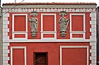
Sculptures of Saints Peter and Paul on the facade of an 18th-century townhouse


Notable people[]
- Margarete Kupfer (1881–1953), German actress
- Artur Pawlowski (born 1973), Polish-Canadian political activist
- Karl-Ernst Schroeter (1912–1943), U-boat commander
- Paul Tschackert (1848–1911), German Protestant theologian and historian
- Julius von Verdy du Vernois (1832–1910), German general
Twin towns – sister cities[]
See twin towns of Gmina Kożuchów.
References[]
- ^ "Population. Size and structure and vital statistics in Poland by territorial division in 2019. As of 30th June". stat.gov.pl. Statistics Poland. 2019-10-15. Retrieved 2020-03-26.
External links[]
| Wikimedia Commons has media related to Kożuchów. |
- Official website (in Polish)
| hide | ||
|---|---|---|
| Town and seat |  | |
| Villages | ||
| show Authority control |
|---|
This Nowa Sól County location article is a stub. You can help Wikipedia by . |
- Cities and towns in Lubusz Voivodeship
- Nowa Sól County
- Nowa Sól County geography stubs