Kobylniki, Szamotuły County
Kobylniki | |
|---|---|
Village | |
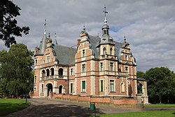 Twardowski Palace in Kobylniki | |
 Kobylniki | |
| Coordinates: 52°40′N 16°33′E / 52.667°N 16.550°E | |
| Country | |
| Voivodeship | Greater Poland |
| County | Szamotuły |
| Gmina | Gmina Obrzycko |
| Time zone | UTC+1 (CET) |
| • Summer (DST) | UTC+2 (CEST) |
| Vehicle registration | PSZ |


Kobylniki [kɔbɨlˈniki] is a village in the administrative district of Gmina Obrzycko, within Szamotuły County, Greater Poland Voivodeship, in west-central Poland.[1] It lies approximately 5 kilometres (3 mi) south of Obrzycko, 8 km (5 mi) north of Szamotuły, and 39 km (24 mi) north-west of the regional capital Poznań.
The landmark of Kobylniki is the Neo-Renaissance Kobylniki Palace, designed by Zygmunt Gorgolewski and built for the Twardowski family.
History[]

Kobylniki was mentioned in 1218 as a possession of the Cistercian monastery Łekno,[2] and later it was a private village of Polish nobility, administratively located in the Poznań County in the Poznań Voivodeship in the Greater Poland Province of the Polish Crown.[3]
During the German occupation of Poland (World War II), the forest of Kobylniki was the site of large massacres of Poles from nearby towns and villages, carried out by the Germans.[4] There is a memorial at the site. During the Intelligenzaktion, Poles from Kobylniki were also murdered in Kościan and the Mauthausen concentration camp.[5]
References[]
- ^ "Central Statistical Office (GUS) - TERYT (National Register of Territorial Land Apportionment Journal)" (in Polish). 2008-06-01.
- ^ Słownik geograficzny Królestwa Polskiego i innych krajów słowiańskich, Tom XV, Część II, Warszawa, 1902, p. 97 (in Polish)
- ^ Atlas historyczny Polski. Wielkopolska w drugiej połowie XVI wieku. Część I. Mapy, plany, Instytut Historii Polskiej Akademii Nauk, Warszawa, 2017, p. 1a (in Polish)
- ^ Maria Wardzyńska, Był rok 1939. Operacja niemieckiej policji bezpieczeństwa w Polsce. Intelligenzaktion, IPN, Warszawa, 2009, p. 199 (in Polish)
- ^ Wardzyńska, p. 198, 231-232
| Seat (not part of the gmina) | ||
|---|---|---|
| Villages | ||
Coordinates: 52°40′N 16°33′E / 52.667°N 16.550°E
This Szamotuły County location article is a stub. You can help Wikipedia by . |
- Villages in Szamotuły County
- Szamotuły County geography stubs