Kogel, Mecklenburg-Vorpommern
Kogel, Mecklenburg-Vorpommern | |
|---|---|
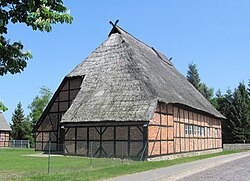 Traditional house in Kogel | |
show Location of Kogel, Mecklenburg-Vorpommern within Ludwigslust-Parchim district | |
 Kogel, Mecklenburg-Vorpommern | |
| Coordinates: 53°30′N 10°55′E / 53.500°N 10.917°ECoordinates: 53°30′N 10°55′E / 53.500°N 10.917°E | |
| Country | Germany |
| State | Mecklenburg-Vorpommern |
| District | Ludwigslust-Parchim |
| Municipal assoc. | Zarrentin |
| Subdivisions | 8 |
| Government | |
| • Mayor | Herbert Wilke |
| Area | |
| • Total | 29.88 km2 (11.54 sq mi) |
| Elevation | 30 m (100 ft) |
| Population (2020-12-31)[1] | |
| • Total | 659 |
| • Density | 22/km2 (57/sq mi) |
| Time zone | UTC+01:00 (CET) |
| • Summer (DST) | UTC+02:00 (CEST) |
| Postal codes | 19246 |
| Dialling codes | 038843, 038851 |
| Vehicle registration | LWL |
| Website | www.zarrentin.de |


Kogel is a municipality in the Ludwigslust-Parchim district, in Mecklenburg-Vorpommern, Germany.
References[]
- ^ "Statistisches Amt M-V – Bevölkerungsstand der Kreise, Ämter und Gemeinden 2020". Statistisches Amt Mecklenburg-Vorpommern (in German). July 2021.
| show Towns and municipalities in Ludwigslust-Parchim |
|---|
| Authority control |
|---|
This Ludwigslust-Parchim location article is a stub. You can help Wikipedia by . |
Categories:
- Municipalities in Mecklenburg-Vorpommern
- Ludwigslust-Parchim
- Bezirk Schwerin
- Ludwigslust-Parchim geography stubs